

 Rain will be falling in South Florida during the first weekend of fall. Summerlike weather is in the forecast for Saturday, with highs in the low 90s and afternoon storms around, especially in the western suburbs of Miami-Dade and Broward and in the interior. Heavy downpours are possible in spots.
 We’ll see more afternoon storms around the region on Sunday, and highs will be in the humid low 90s again.
The summerlike pattern of afternoon storms will continue into the first half of the workweek, and activity will fire up in the western parts of metro Miami-Dade and Broward, the interior, and along the Gulf coast on Monday and Tuesday. Highs both days will be mostly in the upper 80s.
Rain chances go down slightly on Wednesday, with most of the afternoon storms firing in the interior. Wednesday’s highs will be in the upper 80s.

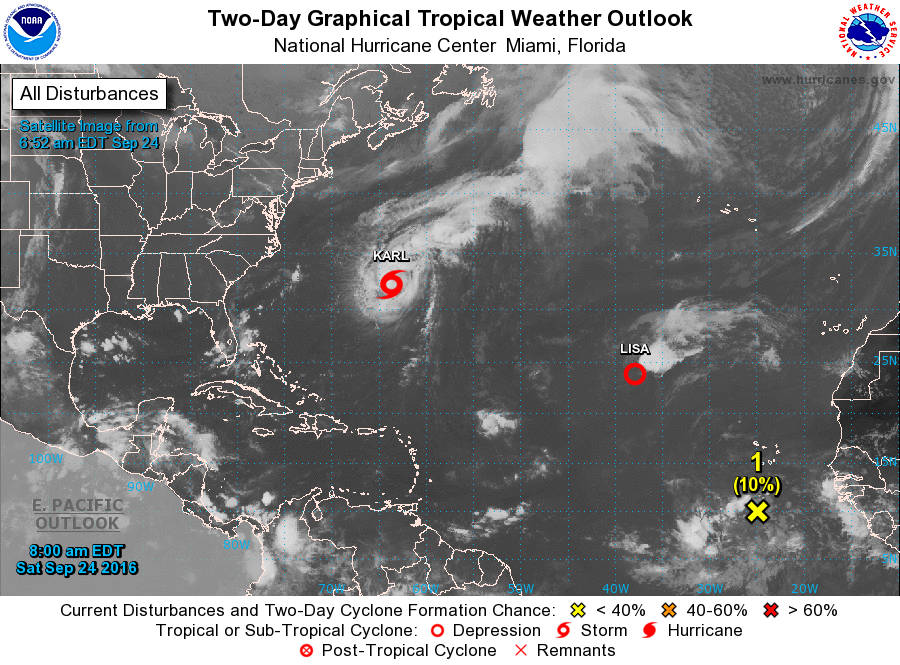 In the tropics, Tropical Storm Karl has begun racing away from Bermuda. At 5 am Saturday, Karl was located near 31.7 North, 64.3 West, and was moving northeast at 17 miles per hour. Maximum sustained winds were 65 miles per hour. Elsewhere, Tropical Depression Lisa was located near 23.8 North, 37.9 West at 5 am Saturday. Lisa was moving northwest at 9 miles per hour and had top winds of 35 miles per hour. It is expected to become post-tropical later on Saturday and quickly weaken. Finally, the wave just west of the African coast has a low chance of developing over the next 5 days as it moves rapidly westward.
Disclaimer
Artificial Intelligence Disclosure & Legal Disclaimer
AI Content Policy.
To provide our readers with timely and comprehensive coverage, South Florida Reporter uses artificial intelligence (AI) to assist in producing certain articles and visual content.
Articles: AI may be used to assist in research, structural drafting, or data analysis. All AI-assisted text is reviewed and edited by our team to ensure accuracy and adherence to our editorial standards.
Images: Any imagery generated or significantly altered by AI is clearly marked with a disclaimer or watermark to distinguish it from traditional photography or editorial illustrations.
General Disclaimer
The information contained in South Florida Reporter is for general information purposes only.
South Florida Reporter assumes no responsibility for errors or omissions in the contents of the Service. In no event shall South Florida Reporter be liable for any special, direct, indirect, consequential, or incidental damages or any damages whatsoever, whether in an action of contract, negligence or other tort, arising out of or in connection with the use of the Service or the contents of the Service.
The Company reserves the right to make additions, deletions, or modifications to the contents of the Service at any time without prior notice. The Company does not warrant that the Service is free of viruses or other harmful components.


")
")


