

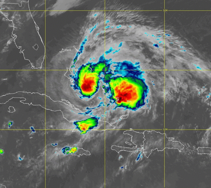
 Hurricane Isaias made landfall on Andros Island in the Bahamas late Saturday morning.At 11 am, Isaias was located near 24.7 North, 77.9 West. This puts it 40 miles from Nassau and 135 miles from Freeport, Grand Bahama Island. Maximum sustained winds were 80 miles per hour. Isaias was moving northwest at 12 miles per hour.
A tropical storm warning is in effect from Ocean Reef to just south of Boca Raton. A hurricane watch is also in effect from Hallandale Beach to just south of Boca Raton. A hurricane warning is in effect from Boca Raton to the Brevard/Volusia county line, and there’s a tropical storm warning from that point northward to Ponte Vedra Beach.
The east coast metro area will see deteriorating conditions on Saturday afternoon into Sunday morning. Coastal areas from extreme northern Miami-Dade to northern Broward will see periods of tropical storm-force winds with stronger gusts. Portions of the metro area further inland will see tropical storm-force gusts. From Boca Raton northward, hurricane conditions are likely.
Storm surge of 1 to 3 feet is possible from North Miami Beach to Jupiter Inlet. All of South Florida is likely to see between 2 and 4 inches of rainfall from Isaias.

People along the east coast of South Florida should stay off the roads and in their homes until the weather improves on Sunday.
Disclaimer
Artificial Intelligence Disclosure & Legal Disclaimer
AI Content Policy.
To provide our readers with timely and comprehensive coverage, South Florida Reporter uses artificial intelligence (AI) to assist in producing certain articles and visual content.
Articles: AI may be used to assist in research, structural drafting, or data analysis. All AI-assisted text is reviewed and edited by our team to ensure accuracy and adherence to our editorial standards.
Images: Any imagery generated or significantly altered by AI is clearly marked with a disclaimer or watermark to distinguish it from traditional photography or editorial illustrations.
General Disclaimer
The information contained in South Florida Reporter is for general information purposes only.
South Florida Reporter assumes no responsibility for errors or omissions in the contents of the Service. In no event shall South Florida Reporter be liable for any special, direct, indirect, consequential, or incidental damages or any damages whatsoever, whether in an action of contract, negligence or other tort, arising out of or in connection with the use of the Service or the contents of the Service.
The Company reserves the right to make additions, deletions, or modifications to the contents of the Service at any time without prior notice. The Company does not warrant that the Service is free of viruses or other harmful components.


