

 Wednesday features morning sun and clouds along the Gulf coast, while the east coast metro area starts the day with lots of clouds. Then widespread showers and storms will develop by late morning and linger into the afternoon. Highs on Wednesday will be in the sticky low 90s.
LIVE RADAR 24/7 (Click Here Then Press Play)
Thursday will be another day of clouds, widespread showers, and storms at times. Thursday’s highs will be in the low 90s.
Friday will feature sun and clouds to start with showers and a few storms moving in by midday. Friday’s highs will be in the low 90s in most locations and the upper 80s right along the Atlantic coast.

Look for lots of clouds and periods of showers and storms on Saturday. Saturday’s highs will be in the low 90s.
Sunday’s forecast calls for a summertime mix of sun, clouds, showers, and a few storms. Highs on Sunday will be in the low 90s.
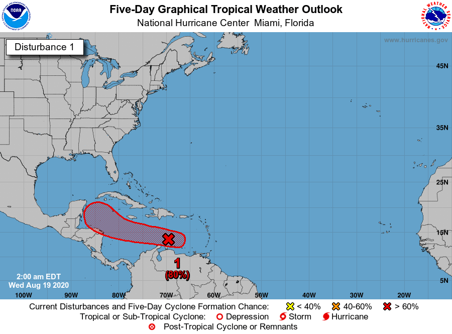 We’re watching the tropics because it is “that time” of year. The first wave we’re tracking is in the eastern Caribbean, where it has a medium chance of developing. But conditions will be more favorable when it reaches the western Caribbean, and this wave has a high chance of becoming a depression in the next 5 days. After that, computer models forecast it entering the Gulf of Mexico, so we’ll watch it closely.
 The second wave we’re watching is about 1000 miles east of the Windward Islands, and this one has a high chance of reaching depression status in the next day or so. This system could affect the Leeward Islands, the Virgin Islands, and Puerto Rico. Computer models indicate a future track close to South Florida, but this is highly uncertain until the system develops a defined center of circulation. We’ll keep a very close eye on this one.
 As if that’s not enough, another wave is expected to emerge off the African coast in a couple of days. Atmospheric conditions are favorable for tropical development in the Atlantic for the next couple of weeks, so stay tuned.
Disclaimer
Artificial Intelligence Disclosure & Legal Disclaimer
AI Content Policy.
To provide our readers with timely and comprehensive coverage, South Florida Reporter uses artificial intelligence (AI) to assist in producing certain articles and visual content.
Articles: AI may be used to assist in research, structural drafting, or data analysis. All AI-assisted text is reviewed and edited by our team to ensure accuracy and adherence to our editorial standards.
Images: Any imagery generated or significantly altered by AI is clearly marked with a disclaimer or watermark to distinguish it from traditional photography or editorial illustrations.
General Disclaimer
The information contained in South Florida Reporter is for general information purposes only.
South Florida Reporter assumes no responsibility for errors or omissions in the contents of the Service. In no event shall South Florida Reporter be liable for any special, direct, indirect, consequential, or incidental damages or any damages whatsoever, whether in an action of contract, negligence or other tort, arising out of or in connection with the use of the Service or the contents of the Service.
The Company reserves the right to make additions, deletions, or modifications to the contents of the Service at any time without prior notice. The Company does not warrant that the Service is free of viruses or other harmful components.


