

 Tuesday features plenty of sun and a few clouds, with maybe a stray shower popping up in the afternoon, especially along the Gulf coast, Highs on Tuesday will be in the low 90s.
LIVE RADAR 24/7 (Click Here Then Press Play)
Wednesday will bring good sun in the morning and some showers and maybe a storm in the afternoon, especially in western parts of South Florida. Wednesday’s highs will be near 90 degrees in the east coast metro area and the low to mid-90s along the Gulf Coast and in the interior.
Thursday will feature mostly sunny skies in the morning and passing showers and storms in the afternoon. Thursday’s highs will be in the low 90s.

Look for lots of sun on Friday with quick showers and maybe a storm in spots during the afternoon. Friday’s highs will be in the low 90s.
Saturday’s forecast will depend on what happens in the tropics this week. But for now, we’ll call for a mix of sun and clouds alternating with passing showers and a few storms. Highs on Saturday will be in the low 90s.
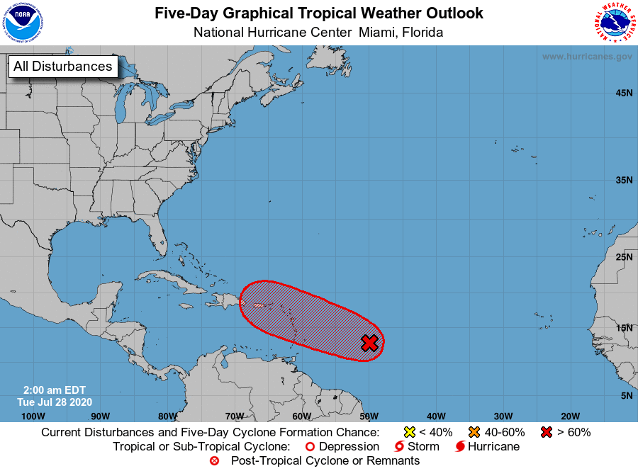 Speaking of the tropics, we’re watching the wave in the Atlantic that’s about 750 miles east of the Lesser Antilles. This wave has a high chance of becoming a depression in the next day or so, probably before reaching the Lesser Antilles on Wednesday. Puerto Rico and the Virgin Islands can expect gusty winds and heavy rains late on Wednesday into Thursday. Beyond that point, the forecast is uncertain. A thick layer of Saharan dust is likely to slow development of this system, and computer models are not in agreement as to the system’s future track. South Florida will need to pay close attention this week.
Disclaimer
Artificial Intelligence Disclosure & Legal Disclaimer
AI Content Policy.
To provide our readers with timely and comprehensive coverage, South Florida Reporter uses artificial intelligence (AI) to assist in producing certain articles and visual content.
Articles: AI may be used to assist in research, structural drafting, or data analysis. All AI-assisted text is reviewed and edited by our team to ensure accuracy and adherence to our editorial standards.
Images: Any imagery generated or significantly altered by AI is clearly marked with a disclaimer or watermark to distinguish it from traditional photography or editorial illustrations.
General Disclaimer
The information contained in South Florida Reporter is for general information purposes only.
South Florida Reporter assumes no responsibility for errors or omissions in the contents of the Service. In no event shall South Florida Reporter be liable for any special, direct, indirect, consequential, or incidental damages or any damages whatsoever, whether in an action of contract, negligence or other tort, arising out of or in connection with the use of the Service or the contents of the Service.
The Company reserves the right to make additions, deletions, or modifications to the contents of the Service at any time without prior notice. The Company does not warrant that the Service is free of viruses or other harmful components.


