

 Friday features lots of hot sun until showers and storms develop during the late afternoon and early evening hours, especially well inland. Highs on Friday will be in the low 90s — but it will feel like the triple digits.
LIVE RADAR 24/7 (Click Here Then Press Play)
Saturday will start with mostly sunny skies, and more widespread showers and storms will develop during the afternoon. Saturday’s highs will be mostly in the low 90s.
Sunday will feature good sun alternating with periods of showers and a few storms. Sunday’s highs will be in the low 90s.

Look for mostly sunny skies Monday morning, followed by showers and storms by midafternoon, especially along the Gulf coast and in the interior. Monday’s highs will be in the low 90s.
Tuesday’s forecast calls for good sun alternating with showers and storms. Highs on Tuesday will be in the low 90s again.
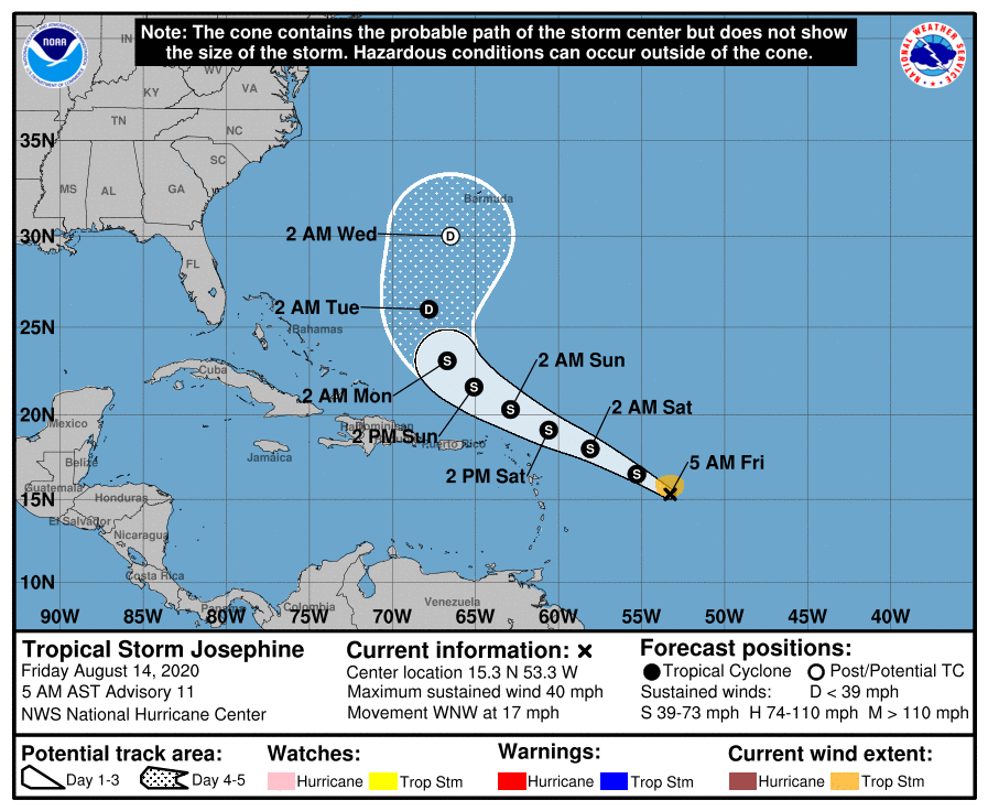 In the tropics, what was Tropical Depression # 11 became Tropical Storm Josephine.on Thursday. At 5 am Friday,, Josephine was located near 15.3 North, 53.3 West, about 680 miles east-southeast of the northern Leeward Islands. Maximum sustained winds were 40 miles per hour. Josephine was moving west-northwest at 17 miles per hour. It is expected to move to the north of the islands this weekend and then turn to the northwest and west well east of South Florida and the Bahamas. Josephine will be battered by wind shear and is expected to weaken into a remnant low by the middle of next week as it nears Bermuda.
 Elsewhere, a low over North Carolina has a medium chance of becoming a tropical or subtropical depression after it moves over water and interacts with the Gulf Stream during the next several days. This feature is forecast to remain well off the U.S. east coast should it develop.
Disclaimer
Artificial Intelligence Disclosure & Legal Disclaimer
AI Content Policy.
To provide our readers with timely and comprehensive coverage, South Florida Reporter uses artificial intelligence (AI) to assist in producing certain articles and visual content.
Articles: AI may be used to assist in research, structural drafting, or data analysis. All AI-assisted text is reviewed and edited by our team to ensure accuracy and adherence to our editorial standards.
Images: Any imagery generated or significantly altered by AI is clearly marked with a disclaimer or watermark to distinguish it from traditional photography or editorial illustrations.
General Disclaimer
The information contained in South Florida Reporter is for general information purposes only.
South Florida Reporter assumes no responsibility for errors or omissions in the contents of the Service. In no event shall South Florida Reporter be liable for any special, direct, indirect, consequential, or incidental damages or any damages whatsoever, whether in an action of contract, negligence or other tort, arising out of or in connection with the use of the Service or the contents of the Service.
The Company reserves the right to make additions, deletions, or modifications to the contents of the Service at any time without prior notice. The Company does not warrant that the Service is free of viruses or other harmful components.


