

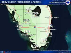
 Thursday features plenty of sun near the Gulf coast and a nice mix of sun and clouds in the east coast metro area. A few showers or a storm are possible, mostly near the Gulf coast and in the interior. Highs on Thursday will be near 90 degrees right at the Atlantic coast and in the low 90s elsewhere.
LIVE RADAR 24/7 (Click Here Then Press Play)
Friday will bring sunny skies in the morning with showers and storms moving in on the sea breezes during the mid to late afternoon. Friday’s highs will be near 90 degrees at the Atlantic coast and in the low 90s everywhere else in South Florida.
Saturday will feature lots of sun to start and some afternoon showers and storms in the east coast metro area. The Gulf coast will see mostly sunny skies followed by afternoon showers and storms. Saturday’s highs will be mostly in the low 90s in the east coast metro area and near 90 degrees along the Gulf coast.

Sunday will see good sun, a few clouds, and the chance of a shower in the morning, but more widespread showers and storms will develop in the afternoon. Sunday’s highs will be near 90 degrees.
Monday’s forecast calls for a mix of sun and clouds in the morning with periods of showers and storms in the afternoon. Highs on Monday will be mostly in the upper 80s.
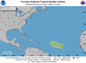 In the tropics, we continue to track the wave in the tropical Atlantic as it approaches a region of hostile upper level winds. The National Hurricane Center now gives this feature a very low chance of developing into a depression during the next five days.
Disclaimer
Artificial Intelligence Disclosure & Legal Disclaimer
AI Content Policy.
To provide our readers with timely and comprehensive coverage, South Florida Reporter uses artificial intelligence (AI) to assist in producing certain articles and visual content.
Articles: AI may be used to assist in research, structural drafting, or data analysis. All AI-assisted text is reviewed and edited by our team to ensure accuracy and adherence to our editorial standards.
Images: Any imagery generated or significantly altered by AI is clearly marked with a disclaimer or watermark to distinguish it from traditional photography or editorial illustrations.
General Disclaimer
The information contained in South Florida Reporter is for general information purposes only.
South Florida Reporter assumes no responsibility for errors or omissions in the contents of the Service. In no event shall South Florida Reporter be liable for any special, direct, indirect, consequential, or incidental damages or any damages whatsoever, whether in an action of contract, negligence or other tort, arising out of or in connection with the use of the Service or the contents of the Service.
The Company reserves the right to make additions, deletions, or modifications to the contents of the Service at any time without prior notice. The Company does not warrant that the Service is free of viruses or other harmful components.


