

Hurricane Dorian, one of the most powerful Atlantic storms ever recorded, is stuck pounding the Bahamas, increasing fears of what will happen when it nears the Florida coast.
Hurricane Dorian was expected to make its closest approach to South Florida on Tuesday morning. We can expect this dangerous hurricane to accelerate, and we’re watching closely for impacts along the central and northern Atlantic coast of our state.
The 11pm ET advisory from the National Hurricane Center had the experts scratching their heads. All day Monday, Dorian remained stationary as a Cat 4 hurricane battering the Bahamas, leaving a trail of death and destruction. Tonight the winds slowed to 130 MPH.

 Florida remains under state of emergency, along with 4 other states. Hurricane warnings have been extended along Florida’s coast.
This was the scene Monday in Palm Bay, Fl. Bands of wind and rain came through as owners and workers secured their stores. Over at the local Lowe’s and WalMart there were plenty of generators, but not any water or other food supplies. In fact the heavy rains caused leaks inside one of the stores.
Here in South Florida, we’ll see gusty winds and fast-moving showers and storms on Tuesday, with conditions gradually improving (especially in Miami-Dade and along the Gulf coast) during the afternoon hours. Highs on Tuesday will be in the mid to up 80s.
Wednesday will feature cloudy skies in the east coast metro area, plenty of sun along the Gulf coast, breezy conditions, and periods of showers and storms throughout the area. Wednesday’s highs will be near 90 degrees.
Thursday will bring a mix of sun and clouds with some mostly afternoon showers and storms. Thursday’s highs will be in the low 90s.
Look for good sun, clouds at times, and a few showers and storms in spots on Friday. Friday’s highs will be in the low 90s.
Saturday’s forecast includes mostly sunny skies and a few afternoon showers and storms. Highs on Saturday will be in the low 90s.
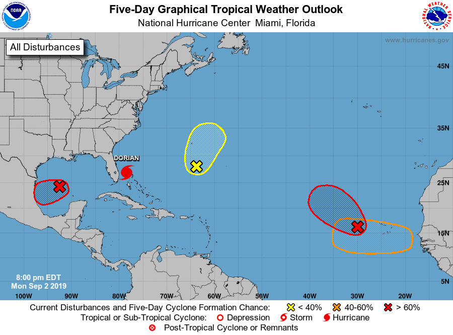 Elsewhere in the tropics, the low in the central Gulf of Mexico has a high chance of developing into a depression before reaching the Mexican coast. The wave in the eastern Atlantic is likely to become a depression in the next couple of days. And the low in the central Atlantic has a medium chance of developing as it moves near Bermuda.
Disclaimer
Artificial Intelligence Disclosure & Legal Disclaimer
AI Content Policy.
To provide our readers with timely and comprehensive coverage, South Florida Reporter uses artificial intelligence (AI) to assist in producing certain articles and visual content.
Articles: AI may be used to assist in research, structural drafting, or data analysis. All AI-assisted text is reviewed and edited by our team to ensure accuracy and adherence to our editorial standards.
Images: Any imagery generated or significantly altered by AI is clearly marked with a disclaimer or watermark to distinguish it from traditional photography or editorial illustrations.
General Disclaimer
The information contained in South Florida Reporter is for general information purposes only.
South Florida Reporter assumes no responsibility for errors or omissions in the contents of the Service. In no event shall South Florida Reporter be liable for any special, direct, indirect, consequential, or incidental damages or any damages whatsoever, whether in an action of contract, negligence or other tort, arising out of or in connection with the use of the Service or the contents of the Service.
The Company reserves the right to make additions, deletions, or modifications to the contents of the Service at any time without prior notice. The Company does not warrant that the Service is free of viruses or other harmful components.


