Home Accuweather.com Category 3 Hurricane Isaias Set to Strike Florida Panhandle Tonight (Live Videos)

Category 3 Hurricane Isaias Set to Strike Florida Panhandle Tonight (Live Videos)

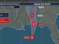
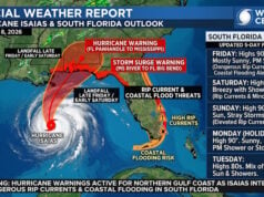
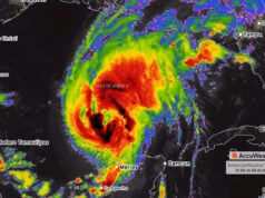
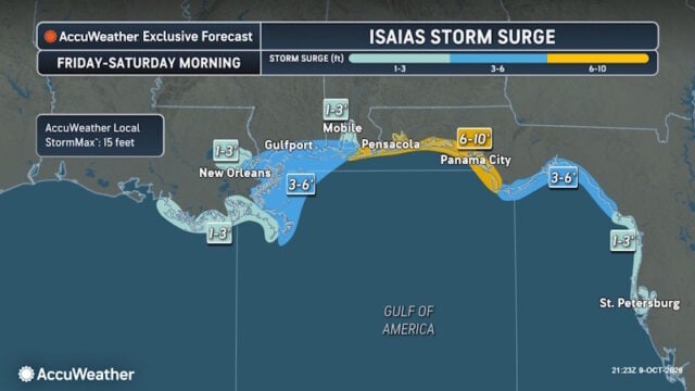
Hurricane Isaias is forecast to make landfall around 10 PM ET Friday as a Category 3 Hurricane with winds up to 115 mph.

This forecasted landfall comes exactly two years to the day since Hurricane Milton made landfall as the last hurricane to strike the United States on October 9, 2024. Milton made landfall near Siesta Key, Florida, at 8:30 PM ET, just 90 minutes earlier on the clock than Isaias’ forecast landfall at 10 PM ET.

Due to flooding rainfall, storm surge, damaging winds and tornadoes, Isaias is now a 3 on the AccuWeather RealImpact™ Scale for Hurricanes in the United States.

“The Saffir-Simpson scale tells you how strong a storm’s winds are. The AccuWeather RealImpact Scale for Hurricanes tells you what a storm will actually do by accounting for flooding rain, storm surge, and total damage and economic loss, not just wind speed,” said AccuWeather expert meteorologist Carl Erickson. “It gives people a far more complete picture of the threat they face.”

Faith Based Events
Isaias_Eye_Path_Zoom

Friday Evening Timeline (ET)

  • 10 PM: Isaias makes landfall between Pensacola Beach and Fort Walton Beach, Florida, as a Category 3 hurricane, with potentially destructive wind gusts of 100–120 mph near the landfall zone. Pensacola, Fort Walton Beach and Destin face the risk of dangerous winds and flooding.
  • Overnight into Saturday: Damaging winds spread inland across Alabama, increasing the risk of downed trees and power outages. Heavy rain raises the threat of flash flooding, with an AccuWeather Local StormMax™ of 25 inches for the overall event. There will be an elevated tornado risk across the Florida panhandle, and southern parts of Georgia and Alabama

Saturday: Flash Flooding, Damaging Winds, and Tornadoes Spread Farther Inland

As Isaias tracks inland Saturday, heavy rain and damaging wind gusts are expected to affect a broad area including Atlanta, Nashville and Charlotte.

  • Storm track: By Saturday evening, the center of Isaias is forecast to be over northern Alabama and Mississippi, tracking north into Tennessee west of Nashville.
  • Flash flooding: Rainfall totals of 4-8 inches could lead to dangerous flash flooding in southern Alabama, western Georgia, and the Florida Panhandle.
  • Mountain flooding: Flash flooding and mudslides are a concern in the southern Appalachians, particularly northern Georgia, western North Carolina, and eastern Tennessee where mountainous terrain can increase runoff.
  • Damaging inland winds: Gusts of 40-60 mph are possible across the broad corridor from southeastern Louisiana through western Georgia, and northward toward the Laurel Highlands in western Pennsylvania, creating the potential for downed trees and localized power outages.
  • Tornado risk: The greatest risk continues across southern Alabama, the Florida Panhandle, southwestern Georgia and southern South Carolina.
  • Atlantic coast impacts: High surf, beach erosion, and coastal flooding may affect areas from northeastern Florida northward along the Southeast and East Coast from Virgina to Florida.

AccuWeather RealImpact™ Scale for Hurricanes

In contrast to the Saffir-Simpson Hurricane Wind Scale, which classifies storms by wind speed only, the AccuWeather RealImpact™ Scale is based on a broad range of important factors. In order to better communicate a more comprehensive representation of the potential impact of a storm to lives and livelihoods, the scale covers not only wind speed but also flooding rain, storm surge and economic damage and loss.


Disclaimer

Artificial Intelligence Disclosure & Legal Disclaimer

AI Content Policy.

To provide our readers with timely and comprehensive coverage, South Florida Reporter uses artificial intelligence (AI) to assist in producing certain articles and visual content.

Articles: AI may be used to assist in research, structural drafting, or data analysis. All AI-assisted text is reviewed and edited by our team to ensure accuracy and adherence to our editorial standards.

Images: Any imagery generated or significantly altered by AI is clearly marked with a disclaimer or watermark to distinguish it from traditional photography or editorial illustrations.

General Disclaimer

The information contained in South Florida Reporter is for general information purposes only.

South Florida Reporter assumes no responsibility for errors or omissions in the contents of the Service. In no event shall South Florida Reporter be liable for any special, direct, indirect, consequential, or incidental damages or any damages whatsoever, whether in an action of contract, negligence or other tort, arising out of or in connection with the use of the Service or the contents of the Service.

The Company reserves the right to make additions, deletions, or modifications to the contents of the Service at any time without prior notice. The Company does not warrant that the Service is free of viruses or other harmful components.