

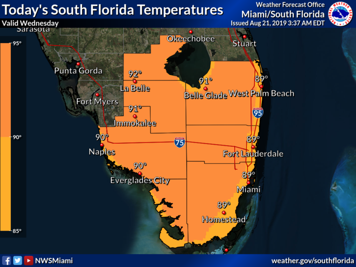
 South Florida will see another August day of heat, showers, and storms on Wednesday. The day features a mix of sun, clouds, and periods of showers and storms, with greater coverage along the Gulf coast and in the interior. An elevated risk of dangerous rip currents is in place at the Atlantic beaches on Wednesday and for the next day or so. Highs on Wednesday will be in the low 90s, but it will feel about 10 degrees hotter.
Thursday will see a bit more sun and fewer showers and storms. Thursday’s highs will be in the low 90s.
Look for rain chances to go up again on Friday, but we’ll also see periods of sun and clouds. Friday’s highs will be near 90 degrees.
Saturday will feature a mix of sun, clouds, showers, and some storms. Saturday’s highs will be near 90 degrees.

Sunday will bring mostly cloudy skies and periods of showers and storms. Highs on Sunday will be near the 90 degree mark.
 In the tropics, the area of low pressure we’ve been watching became Tropical Storm Chantal late on Tuesday, but it’s in the open Atlantic and expected to stay there. At 5 am Wednesday, Chantal was located near 40.3 North, 53.7 West, and was zipping east at 22 miles per hour. Maximum sustained winds were 40 miles per hour. Chantal is expected to weaken into a depression within a couple of days as it meanders in the middle of the ocean.
Disclaimer
Artificial Intelligence Disclosure & Legal Disclaimer
AI Content Policy.
To provide our readers with timely and comprehensive coverage, South Florida Reporter uses artificial intelligence (AI) to assist in producing certain articles and visual content.
Articles: AI may be used to assist in research, structural drafting, or data analysis. All AI-assisted text is reviewed and edited by our team to ensure accuracy and adherence to our editorial standards.
Images: Any imagery generated or significantly altered by AI is clearly marked with a disclaimer or watermark to distinguish it from traditional photography or editorial illustrations.
General Disclaimer
The information contained in South Florida Reporter is for general information purposes only.
South Florida Reporter assumes no responsibility for errors or omissions in the contents of the Service. In no event shall South Florida Reporter be liable for any special, direct, indirect, consequential, or incidental damages or any damages whatsoever, whether in an action of contract, negligence or other tort, arising out of or in connection with the use of the Service or the contents of the Service.
The Company reserves the right to make additions, deletions, or modifications to the contents of the Service at any time without prior notice. The Company does not warrant that the Service is free of viruses or other harmful components.


