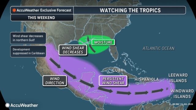
Gulf Rain Storms (Tropical Development?)
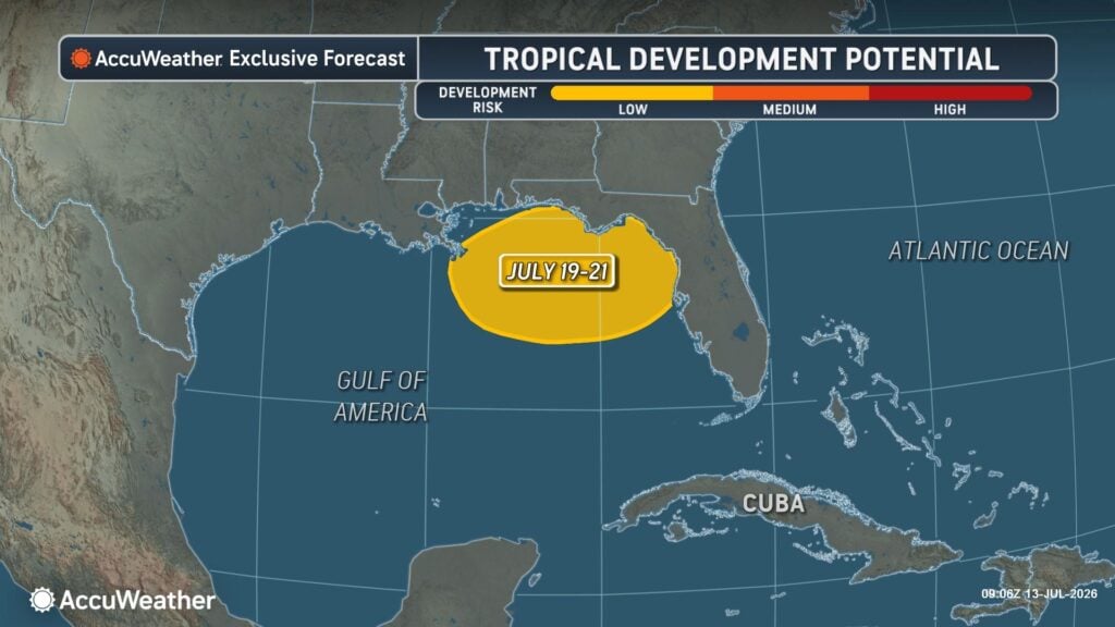
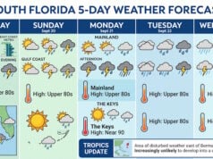
Heavy rain, and flooding could impact the Florida panhandle and northern Gulf region this weekend into early next week as a tropical system tries to organize.
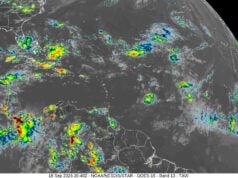
AccuWeather expert meteorologists are tracking a low-risk area in the Gulf which could develop between July 19-21.
“Indications are that the wind shear will drop in the northeastern Gulf this weekend into the start of next week. This combined with exceptionally warm sea-surface temperatures, about 2 to 4 degrees Fahrenheit above historical average for this time of year creates favorable conditions for tropical development,” said AccuWeather Hurricane Expert Alex DaSilva. “Heavy rain would likely be the main impact from this storm. Depending on the organization and intensity of the storm, heavy rain could also move northward into other Southeastern states.”

The development of a tropical storm in this region can be especially dangerous given its close proximity to land, which could give people little time to prepare.
“Have a hurricane plan ready, now. Waiting until a storm is a few days out is too late to figure out your evacuation zone, your route, or where you’ll go. Do that homework now,” DaSilva added. “And don’t just rely on what you’ve done in the past. Evacuation zones can shift over time as storm surge models improve and as past storms reshape the landscape and change flood risks.”
Tropical development is unlikely across the rest of the basin over at least the next seven days due to hostile winds and dry dusty air.
Eastern US Heat Wave
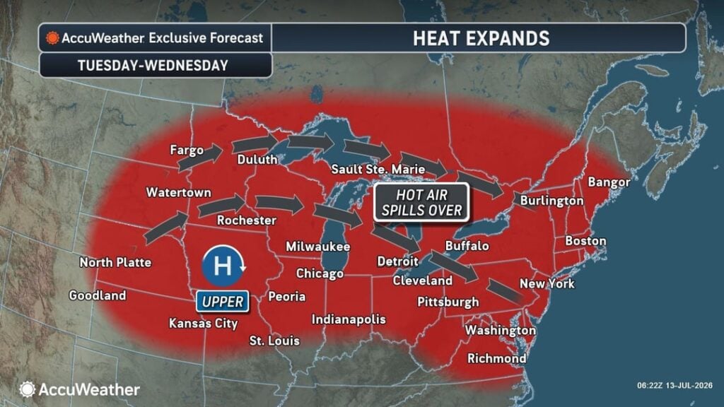
Dangerous heat and humidity will spread across the eastern United States beginning Tuesday, just a week after the record-breaking July Fourth heat wave.
AccuWeather expert meteorologists warn that dangerous humidity, warm nights and prolonged exposure could create hazardous conditions and increase the risk of heat-related illnesses. However, this event is not expected to be as extreme as the previous heat wave.
What to Expect Across the East (Beginning Tuesday)
- High temperatures are expected to climb into the 90s to near 100 degrees across portions of the Ohio Valley, Mid-Atlantic and Northeast
- AccuWeather RealFeel® Temperatures exceeding 100 degrees in many areas, including Philadelphia, New York City and Washington D.C., due to high humidity
- Warm overnight temperatures will provide little opportunity for recovery from daytime heat
- Increased energy demand as air conditioning use surges, utility bills could be very high compared to normal due to this second heat dome in three weeks
“This isn’t just another hot summer week,” said AccuWeather expert meteorologist Elizabeth Danco. “When heat and humidity combine for several days in a row, they can create dangerous conditions that affect everything from public health to the power grid. People should plan ahead, stay hydrated and take frequent breaks if they have to be outdoors, because the heat can become dangerous much faster than many realize.”
Heat Dome Builds Across the Midwest First
Before the hot conditions reach the East, the expanding heat dome will bring dangerous heat to the Plains and Upper Midwest through Wednesday.
- High temperatures of 95-100 degrees are forecast from the northern Rockies through the Dakotas into Minnesota and northern Wisconsin
- AccuWeather RealFeel® Temperatures of 105-115 degrees are expected across portions of the Plains and Midwest
- Several cities including Minneapolis, Chicago, Omaha and Des Moines, could experience their hottest weather of the year so far
AccuWeather RealFeel®
AccuWeather RealFeel® Temperature, which was patented, combines 14 factors to provide the most accurate measure of how representative the current or forecast weather conditions really “feel” to an appropriately dressed person. Find your current and forecasted AccuWeather RealFeel® for the sun and the shade on the AccuWeather app.
Southeast Thunderstorms
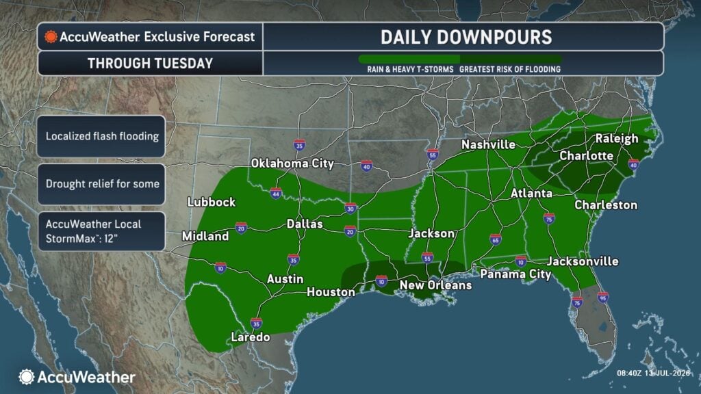
A persistent pattern of slow-moving thunderstorms will bring rounds of heavy rain across the Southeast through at least Tuesday, increasing the risk of flash flooding, travel disruptions and dangerous conditions in areas that experience repeated downpours.
Communities from Louisiana and Mississippi eastward through Alabama, Georgia, the Florida Panhandle and the Carolinas could see multiple rounds of thunderstorms capable of producing torrential rainfall in a short amount of time.
“Even though not every community will experience flooding, storms will repeatedly develop over some of the same locations, allowing rainfall totals to add up quickly,” said AccuWeather senior meteorologist Alan Reppert. “Flash flooding can develop rapidly in urban areas, low-lying locations and places with poor drainage, especially where storms stall or train over the same area.”
Heavy rain and flooding concerns
Widespread rainfall totals of 1-3 inches are expected across much of the Southeast through Tuesday, but locations that receive repeated rounds of thunderstorms could collect twice that amount or more. The AccuWeather Local StormMax™ rainfall amount is 12 inches.
Potential impacts include:
- Rapid rise on small streams and creeks
- Water entering homes, businesses and other low-lying structures
- Flooded roads that may become impassable
- Dangerous travel conditions during the morning and evening commutes
- Delays to flights and outdoor events across the region
Daily Storms to Continue
Rather than one organized storm system, the Southeast will experience a pattern of near-daily afternoon and evening thunderstorms, fueled by abundant Gulf moisture and summertime heat. Though some locations may only receive brief showers, others could be hit by repeated downpours over consecutive days, significantly increasing localized flood risk.
Disclaimer
Artificial Intelligence Disclosure & Legal Disclaimer
AI Content Policy.
To provide our readers with timely and comprehensive coverage, South Florida Reporter uses artificial intelligence (AI) to assist in producing certain articles and visual content.
Articles: AI may be used to assist in research, structural drafting, or data analysis. All AI-assisted text is reviewed and edited by our team to ensure accuracy and adherence to our editorial standards.
Images: Any imagery generated or significantly altered by AI is clearly marked with a disclaimer or watermark to distinguish it from traditional photography or editorial illustrations.
General Disclaimer
The information contained in South Florida Reporter is for general information purposes only.
South Florida Reporter assumes no responsibility for errors or omissions in the contents of the Service. In no event shall South Florida Reporter be liable for any special, direct, indirect, consequential, or incidental damages or any damages whatsoever, whether in an action of contract, negligence or other tort, arising out of or in connection with the use of the Service or the contents of the Service.
The Company reserves the right to make additions, deletions, or modifications to the contents of the Service at any time without prior notice. The Company does not warrant that the Service is free of viruses or other harmful components.