

A burgeoning tropical system in the western Gulf of Mexico has officially intensified, prompting urgent warnings for coastal residents. Potential Tropical Cyclone #1 has been upgraded to Tropical Storm Arthur. While the upgrade signifies a strengthening wind field, meteorologists stress that the wind is not the primary danger. Instead, the main threat from this system remains heavy rain and dangerous flash flooding that could inundate communities from Texas to the Carolinas over the coming days.
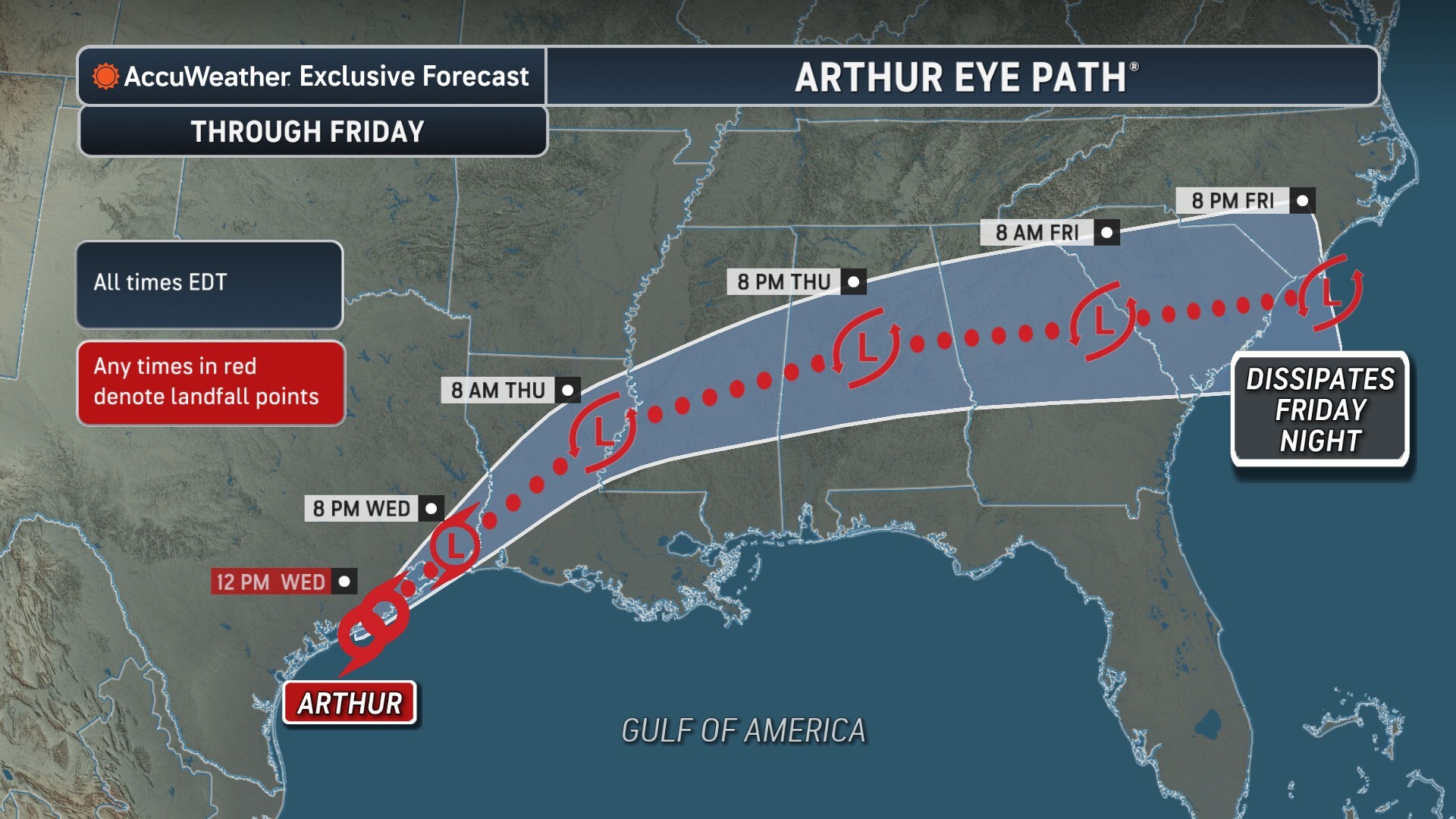
According to data tracked by forecasters, the storm is hugging the Gulf Coast and moving at a pace that allows it to dump immense amounts of water over the same regions. At 11 a.m., Tropical Storm Arthur was located about 40 miles east-northeast of Port O’Connor, Texas, and 190 miles west-southwest of Lake Charles, Louisiana. Maximum sustained winds were clocked at 40 miles per hour, meeting the threshold for a named tropical storm. Arthur was moving northeast at a relatively slow speed of 9 miles per hour, a velocity that increases the risk of prolonged, intense rainfall.
Warnings and Watches Issued Along the Coast
As Arthur crawls closer to the coastline, local authorities have issued a series of coastal watches and warnings to prepare residents for incoming tropical conditions. Currently, a tropical storm warning is in effect from High Island, Texas, to Morgan City, Louisiana. This warning indicates that tropical storm conditions are expected within the specified area.
Additionally, a tropical storm watch has been established from High Island to Sargent, Texas, signaling that tropical storm conditions are possible within the watch area. Residents in these zones are urged to secure loose outdoor items and prepare for rapidly deteriorating road conditions.

A Catastrophic Rainfall Event
While Arthur is forecast to be a short-lived tropical storm, its legacy will be defined by its moisture rather than its winds. Arthur is expected to dump up to a foot of rain in parts of Louisiana, Mississippi, and Alabama. The sheer volume of water entering these river basins and urban drainage systems is expected to cause widespread disruption.
Experts warn that atmospheric conditions are primed for extreme precipitation. “Very heavy rainfall is expected to fall across southeast Louisiana into southern Mississippi, where there can be significant and even life-threatening flooding, before spreading northeastward through the Carolinas and Georgia,” said AccuWeather Hurricane Expert Alex DaSilva.
The primary concern for meteorologists and emergency managers is the rate at which the rain will fall. When rain falls faster than the ground can absorb it, or when drainage systems can divert it, flash flooding occurs almost instantly. “Rainfall rates can reach 2-4 inches per hour, which can cause flooding to occur quickly and result in road closures, especially in urban areas,” DaSilva added.
Widespread Regional Impacts
The geographic footprint of Arthur’s moisture is sprawling. The system is expected to bring at least 5 to 10 inches of rain to portions of Texas, Louisiana, Mississippi, and Alabama, as well as western Georgia and the Florida panhandle. Even areas far from the center of circulation will feel the effects of the tropical moisture surge.
Because the system is moving slowly, significant rain is expected to last through Friday across the Southeast. The zone of greatest risk will dynamically shift eastward as the week progresses:
- Wednesday: The heaviest rain will target far eastern Texas and Louisiana.
- Thursday: The core of the moisture moves into Mississippi and Alabama.
- Friday: The focus of the severe weather and heaviest downpours will shift into Georgia and the Carolinas.
AccuWeather is forecasting 8-12 inches of total rain through Friday across southern parts of Louisiana, Mississippi, and Alabama. Closer to the western edge of the storm, widespread rainfall totals of 2-4 inches will extend from coastal Texas all the way into northern Georgia. Furthermore, locally higher amounts of 4-8 inches are entirely possible for portions of southeastern Texas through southern Alabama.
Severe Weather Notice: The AccuWeather Local StormMax™ for rainfall is a staggering 20 inches across the Gulf Coast states. Any community that experiences these localized peak amounts will likely face catastrophic flooding conditions.
Safety and Preparation
With life-threatening flooding on the horizon, residents in the path of Tropical Storm Arthur should take immediate precautions. Flash flooding is historically the most lethal hazard associated with tropical systems in the United States.
- Turn Around, Don’t Drown: Never attempt to drive through flooded roadways. It takes less than two feet of rushing water to carry away most vehicles, including SUVs and pickups.
- Monitor Local Gauges: Those living in low-lying areas or near rivers and bayous should closely monitor local water levels and be prepared to move to higher ground if ordered to evacuate.
- Prepare for Power Outages: While winds are marginal, waterlogged soil makes it easier for trees to fall, which can knock down power lines and cause localized outages.
As Tropical Storm Arthur continues its northeastward track, staying informed through reliable weather updates will be critical to navigating this high-impact weather event safely.
Sources Used:
- AccuWeather Hurricane Content & Expert Commentary
- Donna Thomas
Disclaimer
Artificial Intelligence Disclosure & Legal Disclaimer
AI Content Policy.
To provide our readers with timely and comprehensive coverage, South Florida Reporter uses artificial intelligence (AI) to assist in producing certain articles and visual content.
Articles: AI may be used to assist in research, structural drafting, or data analysis. All AI-assisted text is reviewed and edited by our team to ensure accuracy and adherence to our editorial standards.
Images: Any imagery generated or significantly altered by AI is clearly marked with a disclaimer or watermark to distinguish it from traditional photography or editorial illustrations.
General Disclaimer
The information contained in South Florida Reporter is for general information purposes only.
South Florida Reporter assumes no responsibility for errors or omissions in the contents of the Service. In no event shall South Florida Reporter be liable for any special, direct, indirect, consequential, or incidental damages or any damages whatsoever, whether in an action of contract, negligence or other tort, arising out of or in connection with the use of the Service or the contents of the Service.
The Company reserves the right to make additions, deletions, or modifications to the contents of the Service at any time without prior notice. The Company does not warrant that the Service is free of viruses or other harmful components.
")
")
")


")
")
")