

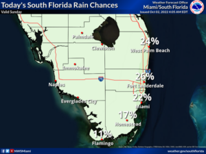
 Sunday features a nice mix of sun and clouds in the east coast metro area and lots of sun along the Gulf coast. A few showers are possible in spots. A moderate risk of dangerous rip currents is in place along the Palm Beach County coast. Highs on Sunday will be in the mid-80s.
LIVE RADAR 24/7 (Click Here Then Press Play)
Monday will bring sunny skies and just the chance of a stray shower around South Florida. Monday’s highs will be mostly in the upper 80s in the east coast metro area and in the mid-80s along the Gulf coast.
Tuesday will feature plenty of sun and a few clouds at times. Tuesday’s highs will be in the mid-80s.

Wednesday will start with lots of sun in the morning in the east coast metro area, but a few clouds and showers will pop up in spots during the afternoon. The Gulf coast will be sunny throughout the day. Wednesday’s highs will be in the mid-80s.
Thursday’s forecast calls for good sun, clouds at times, and a few showers and storms. Highs on Thursday will be in the mid-80s.
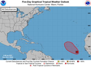 Ian has finally dissipated over Virginia, but its remnants continue to drop rain in the Mid-Atlantic region. Elsewhere, the wave in the eastern Atlantic has a high chance of becoming a depression during the next five days — but it’s expected to stay far away from land.
Disclaimer
Artificial Intelligence Disclosure & Legal Disclaimer
AI Content Policy.
To provide our readers with timely and comprehensive coverage, South Florida Reporter uses artificial intelligence (AI) to assist in producing certain articles and visual content.
Articles: AI may be used to assist in research, structural drafting, or data analysis. All AI-assisted text is reviewed and edited by our team to ensure accuracy and adherence to our editorial standards.
Images: Any imagery generated or significantly altered by AI is clearly marked with a disclaimer or watermark to distinguish it from traditional photography or editorial illustrations.
General Disclaimer
The information contained in South Florida Reporter is for general information purposes only.
South Florida Reporter assumes no responsibility for errors or omissions in the contents of the Service. In no event shall South Florida Reporter be liable for any special, direct, indirect, consequential, or incidental damages or any damages whatsoever, whether in an action of contract, negligence or other tort, arising out of or in connection with the use of the Service or the contents of the Service.
The Company reserves the right to make additions, deletions, or modifications to the contents of the Service at any time without prior notice. The Company does not warrant that the Service is free of viruses or other harmful components.


