

 The disturbance we’ve been watching is now Tropical Depression # 9. Data from a NOAA plane shows that a closed circulation has formed, so as of 5 pm Sunday the disturbance was upgraded as it slowly made its way in the Florida Straits. The first advisory package located TD # 9 near 23.7 North, 81.7 West. The depression was moving west at 9 miles per hour and had maximum sustained winds of 35 miles per hour. TD # 9 is still being affected by wind shear and is not forecast to strengthen much for at least another day. No watches or warnings have been issued, but portions of the Lower Keys could see wind gusts of 39 miles per hour or more Sunday night. TD # 9’s main threat to South Florida will be heavy rain, with accumulations of up to 6 inches in spots over the next several days. The computer models are still split on TD # 9’s future track and strength, but the “cone” indicates a landfall by a tropical storm along Florida’s Gulf coast by late week.
 Here in South Florida, showers and storms will increase on Sunday evening, with activity working its way from the Keys northward. The risk of dangerous rip currents continues at South Florida beaches and will remain at least into Tuesday. Monday will be stormy, with periods of heavy rain throughout South Florida. Monday’s highs will be in the upper 80s. Showers and storms will continue on Tuesday, and localized flooding is possible. Tropical moisture will linger on Wednesday, as what is now TD # 9 slowly moves northward. Look for stormy periods and highs in the upper 80s. Thursday could be on the stormy and cloudy side, with highs again in the upper 80s, all depending on the track and strength of the depression. Friday should finally bring periods of sun, afternoon storms, and highs in the low 90s.
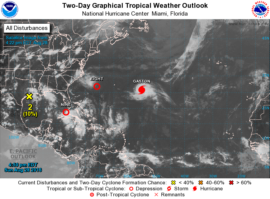 Elsewhere in the tropics, Hurricane Gaston has become the Atlantic season’s first major hurricane, with winds of 115 miles per hour at 5 pm Sunday. Gaston was moving northwest at 5 miles per hour and is not a threat to land.
And the area of low pressure southwest of Bermuda strengthened quickly into Tropical Depression # 8 Sunday morning. It is moving west at 9 miles per hour and is expected to bring heavy rain and gusty winds as it passes near the North Carolina coast in a couple of days.

Disclaimer
Artificial Intelligence Disclosure & Legal Disclaimer
AI Content Policy.
To provide our readers with timely and comprehensive coverage, South Florida Reporter uses artificial intelligence (AI) to assist in producing certain articles and visual content.
Articles: AI may be used to assist in research, structural drafting, or data analysis. All AI-assisted text is reviewed and edited by our team to ensure accuracy and adherence to our editorial standards.
Images: Any imagery generated or significantly altered by AI is clearly marked with a disclaimer or watermark to distinguish it from traditional photography or editorial illustrations.
General Disclaimer
The information contained in South Florida Reporter is for general information purposes only.
South Florida Reporter assumes no responsibility for errors or omissions in the contents of the Service. In no event shall South Florida Reporter be liable for any special, direct, indirect, consequential, or incidental damages or any damages whatsoever, whether in an action of contract, negligence or other tort, arising out of or in connection with the use of the Service or the contents of the Service.
The Company reserves the right to make additions, deletions, or modifications to the contents of the Service at any time without prior notice. The Company does not warrant that the Service is free of viruses or other harmful components.

")


")