Home Weather Warming Up Today And Tomorrow Before Sunday Cold Front Arrives

Warming Up Today And Tomorrow Before Sunday Cold Front Arrives

warming

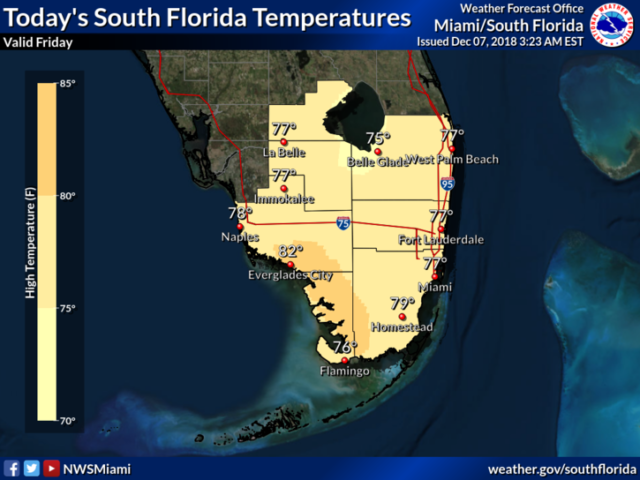
South Florida will be warming up on Friday, but another front will arrive late in the weekend.  In the meantime, Friday features sun, clouds, and maybe a stray shower on a brisk ocean breeze.  A high risk of dangerous rip currents is in place at the Atlantic beaches.  Highs on Friday will be in the upper 70s at most locations.

Saturday will bring a few east coast showers and a mix of sun and clouds.  An elevated risk of rip currents will remain at the Atlantic beaches on Saturday into Sunday.  Saturday’s highs will be near 80 degrees.

The front approaches on Sunday, so we’ll see increasing clouds and showers, especially late in the afternoon and in the evening.  Sunday’s highs will be in the low to mid 80s.

Showers and clouds will linger early on Monday until the front clears the area.  Monday’s highs will be in the upper 70s.

Colder air settles in on Tuesday, with morning lows mostly in the low 50s.  The day will be sunny with a chilly breeze.  Highs on Tuesday will be in the upper 60s to near 70 degrees right at the Atlantic coast.

Donna Thomas has studied hurricanes for two decades. She holds a PhD in history when her experience with Hurricane Andrew ultimately led her to earn a degree in broadcast meteorology from Mississippi State University. Donna spent 15 years at WFOR-TV (CBS4 in Miami-Fort Lauderdale), where she worked as a weather producer with hurricane experts Bryan Norcross and David Bernard. She also produced hurricane specials and weather-related features and news coverage, as well as serving as pool TV producer at the National Hurricane Center during the 2004 and 2005 seasons. Donna also served as a researcher on NOAA's Atlantic Hurricane Database Reanalysis Project. Donna specializes in Florida's hurricane history.