

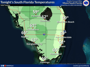
 Tuesday features lots of sun and a gusty ocean breeze. A high risk of dangerous rip currents is in place at the Atlantic beaches through Friday. Highs on Tuesday will be mostly in the mid-80s in the east coast metro area and near 90 degrees along the Gulf coast.
LIVE RADAR 24/7 (Click Here Then Press Play)
 Hazardous marine and beach conditions are expected this week as a low pressure system moves southward over the western Atlantic waters. This system may also bring increased rain chances later this week, especially across the eastern half of South Florida
Wednesday will bring a mix of sun and clouds with a few afternoon showers and storms to the east coast metro area, while it will be sunny again along the Gulf coast. Wednesday’s highs will be mostly in the mid-80s in the east coast metro area and in the upper 80s along the Gulf coast.

Thursday will feature a mix of sun and clouds in the morning in the east coast metro area, and the Gulf coast will start the day with sunny skies. But some showers and storms will develop around South Florida during the mid to late afternoon. Thursday’s highs will be in the mid-80s.
Friday will be sunny once again near the Gulf coast, while the east coast metro area will see mostly sunny skies and a few afternoon showers and storms in spots. Friday’s highs will be in the mid-80s.
Saturday’s forecast calls for plenty of sun, clouds at times, and mostly afternoon showers and storms in spots. Highs on Saturday will be in the upper 80s.
Disclaimer
Artificial Intelligence Disclosure & Legal Disclaimer
AI Content Policy.
To provide our readers with timely and comprehensive coverage, South Florida Reporter uses artificial intelligence (AI) to assist in producing certain articles and visual content.
Articles: AI may be used to assist in research, structural drafting, or data analysis. All AI-assisted text is reviewed and edited by our team to ensure accuracy and adherence to our editorial standards.
Images: Any imagery generated or significantly altered by AI is clearly marked with a disclaimer or watermark to distinguish it from traditional photography or editorial illustrations.
General Disclaimer
The information contained in South Florida Reporter is for general information purposes only.
South Florida Reporter assumes no responsibility for errors or omissions in the contents of the Service. In no event shall South Florida Reporter be liable for any special, direct, indirect, consequential, or incidental damages or any damages whatsoever, whether in an action of contract, negligence or other tort, arising out of or in connection with the use of the Service or the contents of the Service.
The Company reserves the right to make additions, deletions, or modifications to the contents of the Service at any time without prior notice. The Company does not warrant that the Service is free of viruses or other harmful components.


