

The global climate architecture is undergoing a profound reorganization. Ocean waters across the equatorial Pacific are warming at a breakneck pace, signaling the arrival of an El Niño event that is breaking traditional meteorological rules. While standard historical cycles typically manifest in the autumn months, the 2026 signal has ignited significantly earlier than expected. This unusual timeline is raising alarms among atmospheric scientists who track continental weather patterns.
An El Niño is not a single, localized weather event, nor is it a sudden storm that sweeps across a single state overnight. Instead, it is a massive, structural shift in the coupled ocean-atmosphere system of the tropical Pacific. The implications of this shift act as a planetary steering wheel, altering the trajectory of the jet stream, dictating the intensity of hurricane seasons thousands of miles away, and swinging the pendulum between extreme moisture and severe, multi-year droughts across North America.
According to AccuWeather Expert Meteorologist Paul Pastelok, understanding this distinction is vital for long-range planning.
“El Niño is not a storm. It doesn’t affect you directly overnight. But the stronger the signal, the more it can dominate other weather patterns and amplify extremes. This El Niño is developing unusually fast. Most El Niños begin in the fall. This one should start in June and strengthen quickly.”
The sheer speed of this onset means that instead of a gradual transition, the atmosphere is being forced to adapt dynamically right at the start of the high-stakes summer weather season. The traditional buffering periods that allow weather systems to balance out are absent, setting the stage for a highly volatile climatic year.

A Tale of Two Basins: The 2026 Hurricane Divergence
The most immediate and dramatic manifestation of this early-season El Niño is playing out across the world’s tropical oceans. Hurricanes and tropical storms require a precise combination of low atmospheric friction and hot surface waters to organize. By fundamentally altering global wind patterns and ocean temperatures, El Niño is creating two completely opposite realities for the Pacific and Atlantic basins.
The Explosive Pacific Track
In the Eastern Pacific Ocean, tropical activity is running nearly a month ahead of schedule. The basin has already given birth to its third named tropical system of the year, Tropical Storm Cristina. Under normal historical baselines, a third named storm in this region does not materialize until around July 6. The arrival of Cristina weeks ahead of schedule is a direct symptom of what meteorologists describe as a profound marine heatwave.
The underlying driver behind this hyper-accelerated timeline is an abundance of thermal energy stored in the upper layers of the ocean. AccuWeather Hurricane Expert Alex DaSilva points out that thermal energy is the primary fuel source for these massive atmospheric engines.
“Warm water is one of the key ingredients in creating tropical storms,” DaSilva explained. “The rapid pace of early tropical storm development in the Eastern Pacific can be attributed to the near-record water temperatures observed in the Eastern Pacific. This is a very typical pattern in an El Niño setup.”
The scale of this ocean warming is staggering. DaSilva notes that a full-scale marine heatwave is currently in progress, with sea surface temperatures stretching from the Baja South region all the way down the Central American coastline measuring three to five degrees Fahrenheit above historic averages. In several critical corridors, these readings are pushing past previously recorded ceilings.
Because of this unprecedented thermal reservoir, AccuWeather’s Eastern Pacific Hurricane Forecast projects a highly active season, yielding between 17 and 22 named storms. While temporary atmospheric stabilization may offer brief lulls in storm formation, the overarching trend line points toward a front-loaded season characterized by intense, rapid cyclical development.
The Guarded Atlantic Basin
Conversely, the Atlantic basin presents an entirely different structural dynamic. In a standard year, warm Atlantic waters would spell high-end tropical risk. However, an El Niño event acts as a natural damping mechanism for the Atlantic by introducing vertical wind shear. Wind shear refers to the abrupt change in wind speed and direction at different altitudes in the atmosphere. When high-altitude winds blow forcefully across a developing tropical depression, they effectively tilt the storm’s core, disrupting its symmetry and preventing it from stacking vertically and intensifying.
AccuWeather’s 2026 Atlantic hurricane season forecast projects a total of 11 to 16 named storms across the basin. Due to the early-June onset of El Niño conditions, forecasters are leaning toward the lower end of that spectrum, favoring a final tally closer to 11 named storms.
However, meteorologists emphasize that a lower total storm count must not be confused with a lack of danger. The presence of wind shear does not completely eliminate the threat of “homegrown” hurricanes—systems that form rapidly close to the United States mainland, particularly in the warm waters of the Gulf of Mexico or just off the Southeastern coast. Because these storms develop right on the doorstep of populated coastal zones, they offer exceptionally short lead times for emergency preparation and evacuations. It requires only a single major landfalling system to completely upend millions of lives and cause billions of dollars in structural devastation.
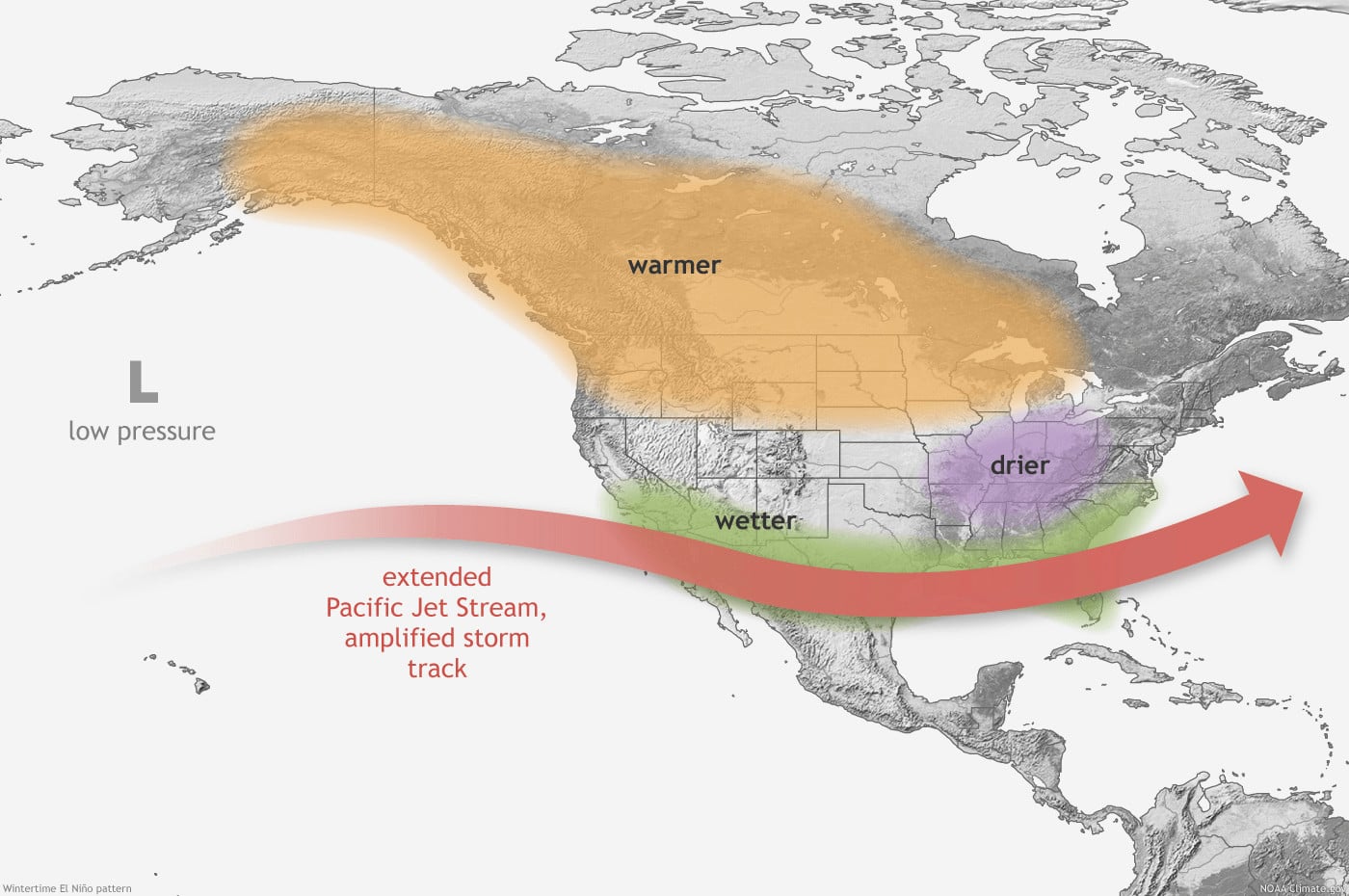
Regional Breakdown: What the Shift Means for You
As the equatorial heat disrupts the global jet stream, the continental United States will find itself partitioned into distinct zones of weather extremes. The altered path of upper-level steering winds means that traditional seasonal expectations will need to be discarded.
| U.S. Region | Key Summer/Fall Expected Impacts | Winter/Spring Extended Outlook | Primary Risks |
| Southwest & California | Heavy tropical moisture incursions, anomalous rain | Intense mountain snow, repeated atmospheric rivers | Flash flooding, debris-rivers, major runoff |
| Northwest & Northern Plains | Anomalous warmth, persistent dry spells | Reduced snowpack, higher baseline temperatures | Prolonged agricultural drought, wildfire ignition |
| Upper Midwest | Warm, sub-average precipitation trends | Milder winter conditions, low seasonal snowfall | Soil moisture depletion, crop yield stress |
| Gulf Coast & Southeast | Pockets of heavy rain mixed with dry spells | Highly active storm track, unseasonably wet | Severe convective storms, winter flash floods |
The Southwest and California: The Threat of Water
In the western United States, particularly across California and the broader Southwest, the primary concern shifts from historical water scarcity to the dangers of sudden, excessive volume. The hyperactive Eastern Pacific storm track has a high probability of drawing deep tropical moisture plumes directly northward into the desert southwest and coastal California.
When these moisture-laden tropical remnants interact with the complex topography of the Western mountains, they can unleash catastrophic downpours. The immediate result is an elevated risk for flash flooding, massive hill-slope runoff, and dangerous “debris-rivers”—fast-moving slurries of mud, rock, and organic matter that can obliterate infrastructure in canyon communities and low-lying valleys.
The Pacific Northwest and Northern Plains: The Tinderbox
While the Southwest braces for moisture, the Pacific Northwest, Northern Plains, and Upper Midwest are projected to face an entirely different set of environmental pressures. The classic El Niño atmospheric configuration tends to push the primary storm track further south, effectively cutting off northern territories from consistent, widespread precipitation.
Throughout the summer and into the early autumn, these northern regions are highly susceptible to experiencing a hotter, significantly drier climate regime. This pattern will actively prolong existing, multi-year agricultural droughts, dry out deep forest fuels, and dramatically escalate the baseline risk for high-intensity wildfires. Farmers and forest management agencies across states like Idaho, Montana, and the Dakotas will face compounding challenges as soil moisture profiles continue to degrade.
The Deep South and Florida: Off-Season Volatility
Moving across the southern tier of the country, El Niño often reserves its most disruptive behavior for the period spanning late fall through early spring. The presence of an energized, southern-branch jet stream creates a highly active storm corridor across the Gulf Coast and the Southeast.
For regions struggling with localized dry spells, this southern storm track can provide vital relief by bringing consistent, heavy rainfall events that recharge depleted aquifers. However, this configuration introduces a distinct danger to the Florida peninsula.
Historically, winter in Florida is characterized as the state’s dry, stable season. Under a mature El Niño framework, however, the enhanced southern storm track can dramatically increase the frequency of severe weather events during mid-to-late winter. Florida residents could face unseasonal outbreaks of severe thunderstorms, damaging straight-line winds, and isolated tornadoes during a time of year when stable, clear weather is typically the norm.
The Extended Multi-Year Drought Horizon (2027 and Beyond)
One of the most insidious aspects of a powerful El Niño event is its long-tail footprint. Environmental systems operate on deep structural delays; the impacts of a massive atmospheric shift do not simply vanish the moment ocean temperatures in the Pacific return to baseline levels.
Meteorological modeling indicates that the persistent patterns established during the peak of this event can lock regional climates into cycles that endure for months, or even years, after the oceanic signal subsides. This is particularly dangerous for the high plains stretching from West Texas all the way northward to the Canadian border.
Paul Pastelok warns that the economic and agricultural toll of this event could reverberate deep into the decade.
“Following the end of El Niño, the next two to three years could end up being significantly drier, leading to drought conditions, especially in parts of the plains from west Texas to the Dakotas,” Pastelok observed. “El Niño patterns tend to be persistent, meaning places that end up drier than average can stay that way for an extended period of time, possibly for months or even years.”
This structural persistence means that even if southern California or the Gulf Coast receive a temporary abundance of rainfall, pockets of severe to extreme drought are highly likely to linger and intensify within the nation’s agricultural heartland, extending well into 2027 and potentially beyond. It underscores the reality that El Niño must be viewed as a multi-year climate catalyst rather than a temporary seasonal variance.
Assessing the Threat of a “Super El Niño”
As meteorologists monitor the exceptional pace of current ocean warming, a critical question dominates the long-range outlook: Are we witnessing the birth of a rare, high-impact “Super El Niño”?
A Super El Niño is a specific, statistically rare intensity level. It is officially designated when sea surface temperature anomalies in the core index region of the equatorial Pacific Ocean reach or exceed 2.0 degrees Celsius (3.6 degrees Fahrenheit) above the historical baseline. Current atmospheric data suggest a realistic, highly concerning 40% chance that the 2026 event will successfully cross this extreme threshold as the year progresses, carrying its intense momentum straight into 2027.
Super El Niño Threshold: ≥ 2.0°C (3.6°F) Above Historic Average
Current Transition Probability: 40% Chance of Development in 2026
Pastelok emphasizes that achieving this tier of intensity requires an alignment of several massive oceanic variables. “That bar is difficult to reach, so current factors contributing to the development need to continue in the second half of 2026 to allow it to build,” he noted.
To provide historical perspective, a Super El Niño event is exceptionally uncommon. According to the newly implemented Relative Oceanic Niño Index (RONI) developed by the Climate Prediction Center, a true Super El Niño has only occurred seven times since comprehensive record-keeping began in the mid-20th century:
- 1957–1958
- 1965–1966
- 1972–1973
- 1982–1983 (The strongest on record by absolute value)
- 1991–1992
- 1997–1998
- 2015–2016
The adoption of the Relative Oceanic Niño Index (RONI) by NOAA represents a significant shift in how these events are classified. As global ocean temperatures rise due to broader climate trends, the old baseline metrics risked misclassifying moderate events as extreme simply because the entire ocean is warmer. The new RONI scale sets a higher, more rigorous mathematical threshold by measuring how warm the equatorial Pacific is relative to the rest of the global tropics. If the 2026 event triggers a Super El Niño designation under the strict RONI criteria, it confirms that the current pool of equatorial water is experiencing truly historic, anomalous warming.
Frequently Asked Questions
What exactly is El Niño?
El Niño is a naturally occurring climate phenomenon characterized by the anomalous warming of sea surface temperatures in the central and eastern equatorial Pacific Ocean. An event is officially noted when temperatures rise at least 0.5 degrees Celsius above the long-term historical baseline. This localized ocean warming alters the global atmospheric overturning circulation, shifting storm tracks across continents and bringing severe drought to some global regions while steering dangerous, historic flooding into others.
What is the final 2026 Atlantic Hurricane Forecast?
AccuWeather’s official team projects a total of 11 to 16 named storms, including 4 to 7 hurricanes. Out of those systems, two to four are forecast to achieve major hurricane status, reaching Category 3 or higher on the Saffir-Simpson scale. Due to the early onset of wind-shear-inducing El Niño patterns, current expectations are leaning heavily toward the lower end of the spectrum (near 11 named storms). Despite the lower count, forecasters still expect three to five direct storm impacts on the United States mainland, meaning coastal residents must remain fully prepared.
What is the final 2026 Eastern Pacific Hurricane Forecast?
Driven by record-breaking sea surface temperatures and a powerful marine heatwave, AccuWeather forecasts a hyperactive season in the Eastern Pacific, with 17 to 22 named storms. This intense level of tropical activity significantly increases the likelihood of direct, hazardous weather impacts on Hawaii, southern California, and coastal portions of Mexico.
What is the AccuWeather RealImpact Scale for Hurricanes™?
Traditional storm tracking relies almost entirely on the Saffir-Simpson Hurricane Wind Scale, which categorizes hurricanes solely by their maximum sustained wind speeds. The AccuWeather RealImpact Scale™ was designed to solve a critical safety flaw in this old model: it accounts for a comprehensive suite of hazards.
Because inland flooding, prolonged storm surge, rainfall volume, and regional economic damage frequently result in greater loss of life and livelihood than wind alone, the RealImpact scale integrates all of these parameters. This provides the public with a clearer, more mathematically complete picture of a storm’s true destructive potential before it makes landfall.
Sources and Links:
- AccuWeather Climatological Press Analysis: AccuWeather Official Press Archive
- NOAA Climate Prediction Center Technical Reference: NOAA CPC Relative Oceanic Niño Index Guidelines
- National Centers for Environmental Information Monitoring: NOAA NCEI ENSO Ocean Temperature Data
Disclaimer
Artificial Intelligence Disclosure & Legal Disclaimer
AI Content Policy.
To provide our readers with timely and comprehensive coverage, South Florida Reporter uses artificial intelligence (AI) to assist in producing certain articles and visual content.
Articles: AI may be used to assist in research, structural drafting, or data analysis. All AI-assisted text is reviewed and edited by our team to ensure accuracy and adherence to our editorial standards.
Images: Any imagery generated or significantly altered by AI is clearly marked with a disclaimer or watermark to distinguish it from traditional photography or editorial illustrations.
General Disclaimer
The information contained in South Florida Reporter is for general information purposes only.
South Florida Reporter assumes no responsibility for errors or omissions in the contents of the Service. In no event shall South Florida Reporter be liable for any special, direct, indirect, consequential, or incidental damages or any damages whatsoever, whether in an action of contract, negligence or other tort, arising out of or in connection with the use of the Service or the contents of the Service.
The Company reserves the right to make additions, deletions, or modifications to the contents of the Service at any time without prior notice. The Company does not warrant that the Service is free of viruses or other harmful components.

")


")