Home Weather Sun And Clouds For Florida Tuesday

Sun And Clouds For Florida Tuesday

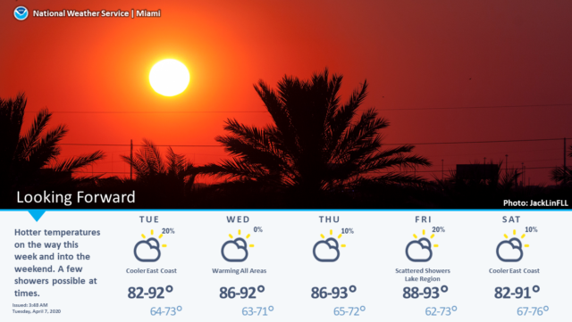
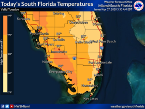
Tuesday features good sun, some clouds at times, and a quick shower in spots along the east coast.  A high risk of dangerous rip currents remains along the Palm Beach County coast, and there’s a moderate rip current risk along the Broward and Miami-Dade coasts.  The beaches are closed; stay at home.  Highs on Tuesday will be in the mid-80s.

LIVE RADAR 24/7 (Click Here Then Press Play)

Wednesday will bring sunny skies to South Florida.  Wednesday’s highs will be in the mid-80s along the Gulf coast and the upper 80s elsewhere.

Thursday will be sunny with a building breeze in the afternoon.  Thursday’s highs will be mostly in the upper 80s, but some inland locations could reach the low 90s.

Friday will be sunny and unseasonably hot again.  Friday’s highs will be near 90 degrees.

Some clouds will be back on Saturday, but we’ll see plenty of sun as well.  Highs on Saturday will be in the upper 80s.

Donna Thomas has studied hurricanes for two decades. She holds a PhD in history when her experience with Hurricane Andrew ultimately led her to earn a degree in broadcast meteorology from Mississippi State University. Donna spent 15 years at WFOR-TV (CBS4 in Miami-Fort Lauderdale), where she worked as a weather producer with hurricane experts Bryan Norcross and David Bernard. She also produced hurricane specials and weather-related features and news coverage, as well as serving as pool TV producer at the National Hurricane Center during the 2004 and 2005 seasons. Donna also served as a researcher on NOAA's Atlantic Hurricane Database Reanalysis Project. Donna specializes in Florida's hurricane history.