Home Accuweather.com South Florida Braces for Heavy Rain and Floods While the Northeast Warms...

South Florida Braces for Heavy Rain and Floods While the Northeast Warms and Sierra Nevada Sees Snow

After a week of severe storms, snow and bitterly cold winds, the Northeast is in for a major weather turnaround. An extended stretch of dry, sunny weather will bring temperatures well above normal later this week, but the return of dry conditions could also raise wildfire concerns across parts of the East.

“Many areas across the eastern U.S. have seen less than half their historical average rainfall during the last month, and this new dry spell will further increase those deficits. Despite the recent rain and snow, the wildfire risk will once again increase as leaf litter dries out as the week progresses,” said AccuWeather senior meteorologist Adam Douty.

page-Nov-16-2026-04-53-37-7435-PM

What AccuWeather Expert Meteorologists Are Tracking

  • Temperatures climb toward 60 degrees: After weekend highs 5-15 degrees below historical averages, temperatures will steadily rebound, reaching 5-15 degrees above typical values in many areas by next weekend. New York City could see highs near 60 degrees by midweek, while other parts of the Northeast could reach the 60s.
  • Extended stretch of sunshine: A large area of high pressure will keep much of the Northeast, Midwest and Southeast dry for several days, offering an opportunity for outdoor activities, holiday decorating and winter preparations
  • Wildfire concerns return: Despite recent rain and snow, many areas across the East remain unusually dry. Another week without significant rainfall could worsen moisture deficits and increase the risk of brush fires as fallen leaves and vegetation dry out.
  • Frosty mornings remain: Clear skies and light winds could bring frost to inland communities and patchy fog in river valleys, even as afternoon temperatures climb

Looking ahead to Thanksgiving: The dry stretch is unlikely to last through the holiday. AccuWeather meteorologists are tracking a developing storm that could bring rain, snow and thunderstorms to the central U.S. late next week followed by showers reaching parts of the East early during Thanksgiving week.

Faith Based Events

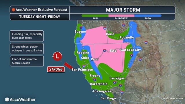
A strong Pacific storm could dump 2-3 feet of snow at California’s Donner Pass starting Wednesday and lasting through Thursday night, potentially halting travel along Interstate 80 as repeated rounds of rain and mountain snow sweep across the west.

“The midweek storm could make travel extremely dangerous to impossible through parts of Sierra Nevada. People planning to cross Donner Pass should consider adjusting their travel plans, as heavy snowfall and strong winds will lead to lengthy delays at the onset and eventually road closures,” said AccuWeather expert meteorologist Alyssa Glenny.

page-14-Nov-16-2026-09-40-08-6540-AM-1

Sierra Snow Could Close Mountain Roads

The storm will arrive behind another system moving inland across California Monday and into Idaho, Utah, Nevada, and Arizona Tuesday. That first storm will bring heavy mountain snow to parts of the Rockies through midweek, with cold rain at lower elevations.

A brief break is expected before the stronger storm reaches Northern California and Oregon Tuesday night. Rain and mountain snow will spread across California, the Southwest, and the Rockies through the middle and latter part of the week.

Several feet of snow could accumulate across the higher elevations of the Sierra Nevada region, paired with gusty winds. At Donner Pass, the heaviest snowfall is expected Wednesday through Thursday night, with road closures likely between Wednesday and Friday. Blizzard conditions are expected across the higher terrain from Wednesday to Friday morning. Drivers should check road conditions before departing and be prepared to change routes or postpone travel.

At lower elevations, heavy rain and rapid runoff could cause flooding and slow travel. Repeated storms will give some communities limited time between rounds of precipitation, while transportation disruptions could affect business operations along mountain corridors.

The storm will eventually move toward the Plains and Midwest, expanding its reach beyond the West later in the week.

Despite immediate hazards, mountain snowfall could help ski resorts build their early-season snowpack. Repeated precipitation can also provide drought relief and improve water supplies.


Disclaimer

Artificial Intelligence Disclosure & Legal Disclaimer

AI Content Policy.

To provide our readers with timely and comprehensive coverage, South Florida Reporter uses artificial intelligence (AI) to assist in producing certain articles and visual content.

Articles: AI may be used to assist in research, structural drafting, or data analysis. All AI-assisted text is reviewed and edited by our team to ensure accuracy and adherence to our editorial standards.

Images: Any imagery generated or significantly altered by AI is clearly marked with a disclaimer or watermark to distinguish it from traditional photography or editorial illustrations.

General Disclaimer

The information contained in South Florida Reporter is for general information purposes only.

South Florida Reporter assumes no responsibility for errors or omissions in the contents of the Service. In no event shall South Florida Reporter be liable for any special, direct, indirect, consequential, or incidental damages or any damages whatsoever, whether in an action of contract, negligence or other tort, arising out of or in connection with the use of the Service or the contents of the Service.

The Company reserves the right to make additions, deletions, or modifications to the contents of the Service at any time without prior notice. The Company does not warrant that the Service is free of viruses or other harmful components.