

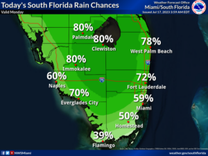
 Monday features hot sun and some clouds in the morning, followed by plenty of storms in the mid afternoon and lingering through the evening. The heat advisory has been extended for all of South Florida until at least Tuesday evening. Highs on Monday will be mostly in the mid 90s — but it will feel at least 10 degrees hotter, so stay hydrated and out of the sun.
LIVE RADAR 24/7 (Click Here Then Press Play)
Tuesday will bring some sun, more clouds, and mainly afternoon and evening showers and storms. Tuesday’s highs will be mostly in the low 90s in the east coast metro area and in the mid-90s along the Gulf coast and in the Keys.
Wednesday will feature a mix of sun, clouds, showers, and storms. Heavy rain is possible at times, especially near the Gulf coast. Wednesday’s highs will be mostly in the mid-90s.

Thursday will see lots of showers and storms alternating with sun and clouds. Thursday’s highs will be mostly in the mid-90s.
Friday’s forecast calls for another day of showers and storms with some early sun. Highs on Friday will be in the mid-90s.
In the tropics, Don is now a subtropical depression in the middle of the Atlantic. At 5 am, Don was about 955 miles west of the Azores and had maximum sustained winds of 35 miles per hour. It was moving east at 9 miles per hour. Don continues to loop around and is now forecast to strengthen a bit and transition into a fully tropical system — but it will remain far from land. Elsewhere in the tropical Atlantic, it’s quiet right now.
Disclaimer
Artificial Intelligence Disclosure & Legal Disclaimer
AI Content Policy.
To provide our readers with timely and comprehensive coverage, South Florida Reporter uses artificial intelligence (AI) to assist in producing certain articles and visual content.
Articles: AI may be used to assist in research, structural drafting, or data analysis. All AI-assisted text is reviewed and edited by our team to ensure accuracy and adherence to our editorial standards.
Images: Any imagery generated or significantly altered by AI is clearly marked with a disclaimer or watermark to distinguish it from traditional photography or editorial illustrations.
General Disclaimer
The information contained in South Florida Reporter is for general information purposes only.
South Florida Reporter assumes no responsibility for errors or omissions in the contents of the Service. In no event shall South Florida Reporter be liable for any special, direct, indirect, consequential, or incidental damages or any damages whatsoever, whether in an action of contract, negligence or other tort, arising out of or in connection with the use of the Service or the contents of the Service.
The Company reserves the right to make additions, deletions, or modifications to the contents of the Service at any time without prior notice. The Company does not warrant that the Service is free of viruses or other harmful components.


