

 South Florida will see plenty of showers, storms, and clouds on Tuesday, but a taste of fall is on the way. After some overnight showers, Tuesday features clouds and periods of showers and storms as our first real front in some time approaches. We’ll also see a gradually decreasing risk of dangerous rip currents at the Atlantic beaches. Highs on Tuesday will be in the mid 80s.
 Showers and a few storms continue overnight and will linger into early Wednesday. Then the day will bring a mix of sun and clouds as drier and cooler air works its way in, giving us a taste of fall. Highs on Wednesday will be in the upper 70s.
Thursday morning will be noticeably cooler, with lows in the upper 50s to low 60s at the coast. The day features good sun and a few clouds. Highs on Thursday will be in the upper 70s.
Friday morning will feel like fall, with lows near 60 degrees. We’ll see sun, a few clouds, and maybe a stray shower on the breeze. Friday’s highs will be in the low 80s.

Tropical moisture will stream in on Saturday, and we’ll see clouds, and showers and storms. Highs on Saturday will be in the mid 80s.
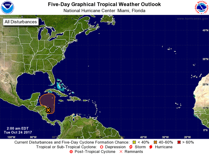 In the tropics, the area of showers and storms off the coast of Central America has a medium chance of becoming a depression during the next several days as it moves northward. Regardless of development, it is expected to bring us some tropical moisture this weekend.
Disclaimer
Artificial Intelligence Disclosure & Legal Disclaimer
AI Content Policy.
To provide our readers with timely and comprehensive coverage, South Florida Reporter uses artificial intelligence (AI) to assist in producing certain articles and visual content.
Articles: AI may be used to assist in research, structural drafting, or data analysis. All AI-assisted text is reviewed and edited by our team to ensure accuracy and adherence to our editorial standards.
Images: Any imagery generated or significantly altered by AI is clearly marked with a disclaimer or watermark to distinguish it from traditional photography or editorial illustrations.
General Disclaimer
The information contained in South Florida Reporter is for general information purposes only.
South Florida Reporter assumes no responsibility for errors or omissions in the contents of the Service. In no event shall South Florida Reporter be liable for any special, direct, indirect, consequential, or incidental damages or any damages whatsoever, whether in an action of contract, negligence or other tort, arising out of or in connection with the use of the Service or the contents of the Service.
The Company reserves the right to make additions, deletions, or modifications to the contents of the Service at any time without prior notice. The Company does not warrant that the Service is free of viruses or other harmful components.


")


