

 South Florida will see the return of some showers on Sunday, setting the stage for a rather wet week. Sunday features a mix of sun and clouds with passing showers on a gentler breeze than we’ve seen in recent days. But the risk of dangerous rip currents remains elevated at the Atlantic beaches and will reach high levels again during the workweek. Highs on Sunday will be mostly in the mid 80s.
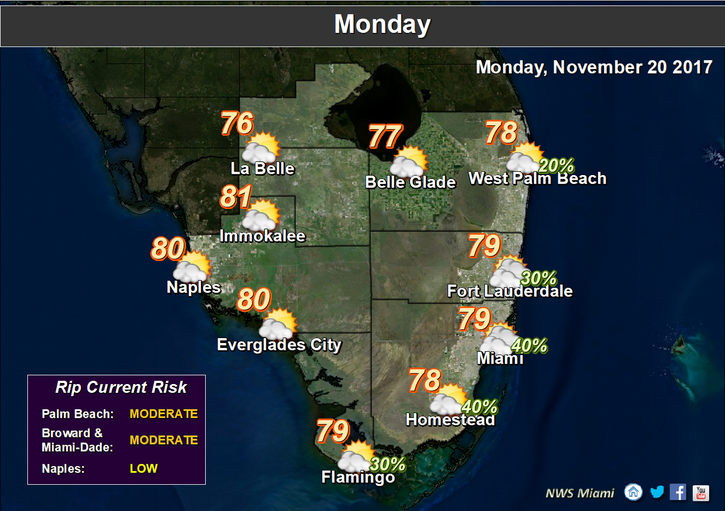 Monday will see a front move in, bringing showers at times, plenty of clouds, and breezy conditions. Monday’s highs will be in the upper 70s.
Clouds and showers will linger on Tuesday as the front sticks around. Tuesday’s highs will be near 80 degrees.
Look for another day of showers and clouds on Wednesday ahead of a front pushing into central Florida. Wednesday’s highs will be near 80 degrees.

We’ll have showers along with the turkey on Thanksgiving Day as the front moves in. Highs on Thursday will be near 80 degrees.
The tropics are quiet right now.
Disclaimer
Artificial Intelligence Disclosure & Legal Disclaimer
AI Content Policy.
To provide our readers with timely and comprehensive coverage, South Florida Reporter uses artificial intelligence (AI) to assist in producing certain articles and visual content.
Articles: AI may be used to assist in research, structural drafting, or data analysis. All AI-assisted text is reviewed and edited by our team to ensure accuracy and adherence to our editorial standards.
Images: Any imagery generated or significantly altered by AI is clearly marked with a disclaimer or watermark to distinguish it from traditional photography or editorial illustrations.
General Disclaimer
The information contained in South Florida Reporter is for general information purposes only.
South Florida Reporter assumes no responsibility for errors or omissions in the contents of the Service. In no event shall South Florida Reporter be liable for any special, direct, indirect, consequential, or incidental damages or any damages whatsoever, whether in an action of contract, negligence or other tort, arising out of or in connection with the use of the Service or the contents of the Service.
The Company reserves the right to make additions, deletions, or modifications to the contents of the Service at any time without prior notice. The Company does not warrant that the Service is free of viruses or other harmful components.


")
")
")


 Cold Sweat Ice Cream Features Peppers So Hot You Must Sign A Waiver Before Eating It.")
