

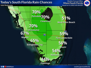
 Wednesday features an increasing chance of showers and storms, especially in the mid to late afternoon. Otherwise, we’ll see a mix of sun and clouds. Highs on Wednesday will be in the low 90s.
LIVE RADAR 24/7 (Click Here Then Press Play)
Thursday will bring periods of showers and storms alternating with good sun and some clouds. The greatest rain chances will be in areas near the Gulf coast. Thursday’s highs will be in the low 90s.
Friday will feature sun, clouds, and a few storms in the morning and plenty of storms in the afternoon hours. Look for breezy conditions in the east coast metro area and an increasing risk of dangerous rip currents at the Atlantic beaches. Friday’s highs will be in the low 90s.

Saturday will see more clouds than sun, with passing showers in the morning and periods of storms in the afternoon. Saturday’s highs will be near 90 degrees.
Sunday’s forecast calls for lots of clouds, sun at times, and periods of showers and storms. The east coast metro area will be breezy. Highs on Sunday will be mostly in the low 90s.
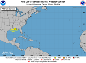 In the tropics, the area of low pressure in the extreme northern Gulf of Mexico is unlikely to develop into a depression because it’s so close to land. But expect it to bring heavy rain to the Florida panhandle westward into Louisiana.
Disclaimer
The information contained in South Florida Reporter is for general information purposes only.
The South Florida Reporter assumes no responsibility for errors or omissions in the contents of the Service.
In no event shall the South Florida Reporter be liable for any special, direct, indirect, consequential, or incidental damages or any damages whatsoever, whether in an action of contract, negligence or other tort, arising out of or in connection with the use of the Service or the contents of the Service. The Company reserves the right to make additions, deletions, or modifications to the contents of the Service at any time without prior notice.
The Company does not warrant that the Service is free of viruses or other harmful components


