Home Weather Sat Update #4: Dorian Prompts Tropical Storm Watches Along East Coast

Sat Update #4: Dorian Prompts Tropical Storm Watches Along East Coast

Html code here! Replace this with any non empty text and that's it.

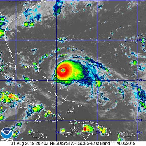
  The big news from the 5 pm Saturday advisory from the National Hurricane Center is that a tropical storm watch is now in effect from Deerfield Beach to Sebastian Inlet (just north of Vero Beach).  While Dorian’s core is forecast to stay offshore, uncertainty regarding the exact track and the ultimate size of Dorian’s wind field are the reasons for the tropical storm watch.  The rest of South Florida remains out of the cone, but tropical storm force winds and periods of heavy rain are possible from Sunday night until early on Tuesday.  Dangerous swells, rip currents, and coastal flooding are all expected along the Atlantic coast.

[vc_btn title=”Stay Up-to-Date With The Weather With Our Interactive Page” color=”primary” link=”url:https%3A%2F%2Fsouthfloridareporter.com%2Fdorian%2F|title:Interactive%20Page|target:%20_blank|”]

At 5 pm Saturday, Dorian was located near 26.2 North, 74.4 West, about 170 miles east of Great Abaco Island in the Bahamas and 355 miles east of West Palm Beach.  Maximum sustained winds were 150 miles per hour.  Dorian was moving west at 8 miles per hour.

Dorian’s outer bands will arrive in the northwestern Bahamas on Saturday night,   The hurricane is expected to slow, which will increase the length of time that the islands are exposed to damaging winds and flooding rains.  This is expected to be a devastating hurricane event for those areas within Dorian’s eye wall, and all measures to protect lives should be taken as soon as possible.

[/vc_column_text][vc_message message_box_style=”solid-icon” message_box_color=”blue”]By Donna Thomas, SouthFloridaReporter.com, certified Meteorologist, Aug. 31, 2019[/vc_message]
Donna Thomas has studied hurricanes for two decades. She holds a PhD in history when her experience with Hurricane Andrew ultimately led her to earn a degree in broadcast meteorology from Mississippi State University. Donna spent 15 years at WFOR-TV (CBS4 in Miami-Fort Lauderdale), where she worked as a weather producer with hurricane experts Bryan Norcross and David Bernard. She also produced hurricane specials and weather-related features and news coverage, as well as serving as pool TV producer at the National Hurricane Center during the 2004 and 2005 seasons. Donna also served as a researcher on NOAA's Atlantic Hurricane Database Reanalysis Project. Donna specializes in Florida's hurricane history.