

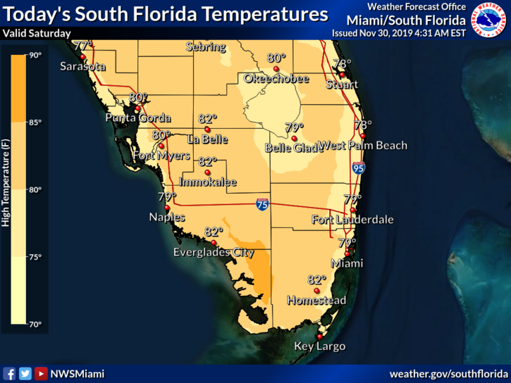
 Our Saturday starts with patchy fog in some inland locations. But by mid-morning we’ll see good sun and a few clouds on an ocean breeze. A moderate risk of dangerous rip currents is in place at the beaches of Miami-Dade and Broward, while there’s a high risk of rip currents along the Palm Beach County coast. Highs on Saturday will be near 80 degrees.
LIVE RADAR 24/7 (Click Here Then Press Play)
Sunday will bring sunny skies to the Gulf coast and a nice mix of sun and clouds elsewhere. Sunday’s highs will be near 80 degrees.
Some showers will move in early on Monday in advance of a strong front, but there will also be periods of sun. Monday’s highs will be in the upper 70s along the Gulf coast and a few degrees warmer in the east coast metro area.

Colder air will move in overnight, and Tuesday morning lows will be in the 50s. Even with lots of sun, temperatures on Tuesday will struggle to reach 70 degrees.
Wednesday morning will see lows in the 50s again. Then we’ll see good sun and the start of a slow warming trend. Highs on Wednesday will be in the low 70s.
The tropics are quiet as the 2019 Atlantic hurricane season comes to a close on Saturday. With 18 named storms and 6 hurricanes, it’s been quite a busy season — and a tragic one for the northwestern Bahamas, which continue to recover from the effects of Hurricane Dorian.
Disclaimer
Artificial Intelligence Disclosure & Legal Disclaimer
AI Content Policy.
To provide our readers with timely and comprehensive coverage, South Florida Reporter uses artificial intelligence (AI) to assist in producing certain articles and visual content.
Articles: AI may be used to assist in research, structural drafting, or data analysis. All AI-assisted text is reviewed and edited by our team to ensure accuracy and adherence to our editorial standards.
Images: Any imagery generated or significantly altered by AI is clearly marked with a disclaimer or watermark to distinguish it from traditional photography or editorial illustrations.
General Disclaimer
The information contained in South Florida Reporter is for general information purposes only.
South Florida Reporter assumes no responsibility for errors or omissions in the contents of the Service. In no event shall South Florida Reporter be liable for any special, direct, indirect, consequential, or incidental damages or any damages whatsoever, whether in an action of contract, negligence or other tort, arising out of or in connection with the use of the Service or the contents of the Service.
The Company reserves the right to make additions, deletions, or modifications to the contents of the Service at any time without prior notice. The Company does not warrant that the Service is free of viruses or other harmful components.


