

If you live anywhere near the Gulf Coast or parts of the Southeast, it is time to dig out the rain gear and keep your weather alerts turned up high. The atmosphere right across the entire region is completely primed for a massive, multi-day soaking this week. We are talking about repeated rounds of torrential rain that could easily trigger severe, life-threatening flash flooding stretching all the way from Texas eastward into Georgia.
According to AccuWeather experts, this isn’t just your standard summertime afternoon thunderstorm setup. The ingredients coming together over the Gulf of Mexico are exceptionally concerning, creating a prolonged weather event that could leave some communities underwater. Upgrades to the forecast indicate this system is rapidly organizing, prompting the deployment of specialized tracking to pinpoint where the heaviest impacts will fall.
The First AccuWeather Tropical Eye Path® of 2026
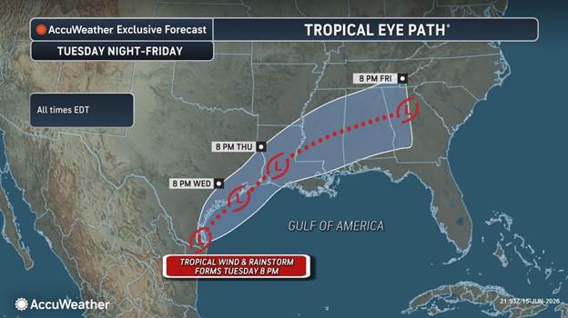 To reflect the escalating danger, AccuWeather hurricane experts have just released a projected track for a distinct Tropical Rainstorm designed to further fuel the life-threatening flash flood risk from Texas across the Southeast this week. This tracking map marks the very first AccuWeather Tropical Eye Path® of the 2026 Atlantic Hurricane Season, signaling a critical transition in the severity of the system.

This Tropical Rainstorm is officially expected to develop later Tuesday near the Texas-Mexico border. As this organized rainstorm moves northeast through Friday, an expansive swath of very heavy rainfall is projected to roll from eastern Mexico through southern and eastern Texas, eventually pushing deep into the western Carolinas and Georgia.
The primary danger comes from the storm’s position. If the system moves farther off the coast and tracks over the exceptionally warm waters of the western Gulf of Mexico, it may intensify into an official tropical depression or named tropical storm. However, meteorologists emphasize that whether it gains a name or remains classified as a rainstorm, the catastrophic water potential remains exactly the same.
The Perfect Meteorological Storm: Why the Atmosphere is Primed
 To understand why this week is different, you have to look at how different weather ingredients are clashing right over our heads. Right now, a tremendous surge of deep tropical moisture from the Gulf of Mexico is moving inland. But instead of just passing through, this moisture is colliding with a stalled frontal boundary draped across the southern United States. When a front stops moving, it acts like a giant atmospheric wall. The incoming tropical air hits it, rises, and dumps its moisture over the exact same locations day after day.
Dan DePodwin, AccuWeather’s Vice President of Forecasting Operations, highlighted the severity of this specific configuration. “While flash flooding is a risk many days during the year, this week is especially concerning due to repeated rounds of torrential rain fueled by tropical moisture and perhaps a tropical rainstorm,” DePodwin explained. “These types of weather patterns in the past have often yielded major, life-threatening flash flooding.”
Adding fuel to the fire, the region is dealing with leftover energy from the Pacific and a long-distance traveler from the Atlantic. Over the past weekend, moisture from what used to be Tropical Storm Cristina in the Eastern Pacific crossed over Mexico and pushed straight into Texas. At the same time, a tropical wave of low pressure—a trackable disturbance that originally started all the way out in Africa—traveled across the Atlantic and entered the western Gulf.
When these separate systems hold hands over warm Gulf waters, severe weather escalates. AccuWeather Lead Hurricane Expert Alex DaSilva noted that this combination could enable a named tropical storm to develop within the next two days. “Regardless of any organized development into a named storm, this will bring heavy rains and can bring life-threatening flash flooding across portions of eastern Texas and Louisiana over the coming days,” DaSilva warned.
Visualizing the Danger: How Flash Floods Explode
Opens in a new window
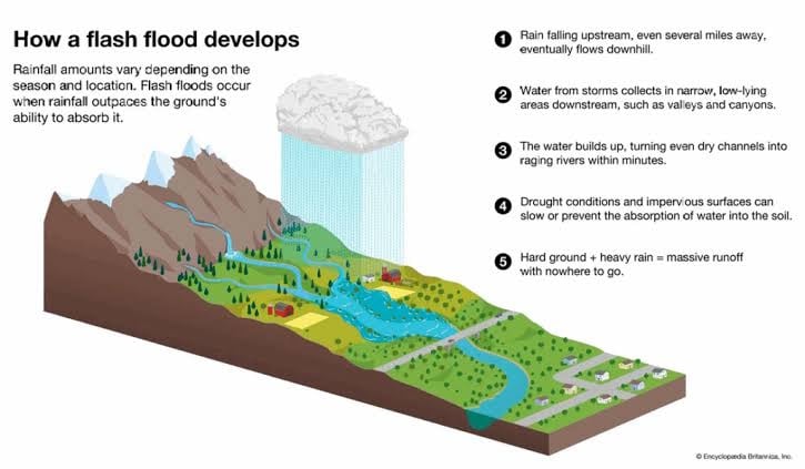
How a flash flood develops. Source: Climate Impacts Tracker Asia / What Are Flash Floods? Causes, Effects, Science, and Adaptation
It is easy to underestimate heavy rain until the water is lapping at your car door. To understand why this particular setup is so dangerous, it helps to look at the physical mechanics of a flash flood.
As the diagram illustrates, a flash flood occurs when the volume of rainfall exceeds the ground’s capacity to absorb it. When torrential rain drops multiple inches of water in a tiny window of time, the soil becomes instantly saturated. In modern towns and cities, impervious surfaces like concrete roads, sidewalks, and parking lots make things even worse. The water cannot sink into the ground at all. Instead, it becomes massive runoff with nowhere to go. It sweeps into local streams, drainage ditches, and narrow, low-lying areas downstream, turning dry pavement or slow-moving creeks into raging rivers within minutes.
Rainfall rates in the heaviest storms could reach an incredible 2 to 4 inches per hour. This extreme rate triggers a rapid rise in local water levels, which is particularly dangerous in densely populated urban environments.
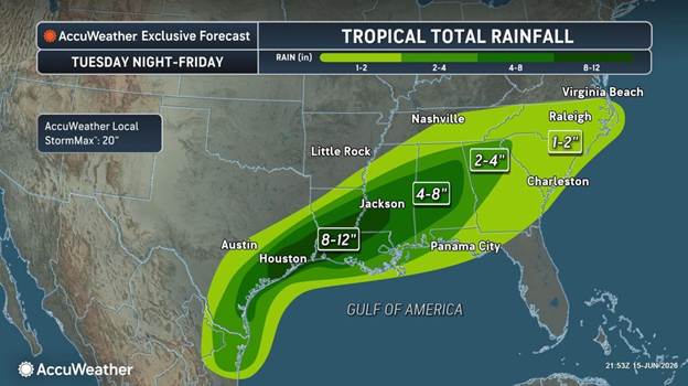
Eye-Popping Numbers: The Rain Forecast Breakdown
 The rainfall predictions coming out of the AccuWeather forecast center are staggering, and the risk is expected to hold strong all the way through Friday. However, you don’t have to wait until mid-week for the trouble to start. Prior to the Tropical Rainstorm fully enhancing the rainfall totals, significant flooding is still expected tonight (Monday) into Tuesday, especially across southeast Texas and Louisiana.
Once the main system gets moving, the bulls-eye for the absolute worst of the weather looks to be centered squarely on eastern Texas and southwest Louisiana. Between Wednesday and Friday, cities like Houston and neighboring communities are staring down a forecast of 8 to 12 inches of rain. When you spread that much water over just a couple of days, urban flooding is an absolute certainty.
A much more widespread blanket of 2 to 4 inches of rain is projected to accumulate from coastal Texas all the way across the Southeast. Within that broader zone, local pockets from southeastern Texas through central Alabama could easily see significantly higher amounts, hovering between 4 to 8 inches.
To give you an idea of the absolute worst-case scenario, meteorologists use a metric called the AccuWeather Local StormMax™. For this specific event, the StormMax™ is a jaw-dropping 18 inches across portions of the region. If an isolated, slow-moving band of storms stalls out over your neighborhood, you could see a foot and a half of water drop out of the sky before Saturday arrives.
Travel Chaos and World Cup Complications
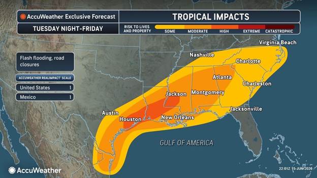
With this volume of water coming down, major travel disruptions are inevitable. In urban areas where the heaviest downpours hit, flooding will occur incredibly quickly, resulting in immediate road closures. Major interstate corridors like Interstate 10 and Interstate 20 are highly vulnerable to flash flooding, standing water, and hydroplaning risks. If you are planning a road trip or rely on these routes for your daily commute, you need to prepare for sudden closures, major traffic jams, and significantly slowed travel times. Airports across the region are also likely to see compounding flight delays and potential cancellations as these intense downpours roll through.
The timing of this storm system is particularly problematic for sports fans. This Wednesday, Houston is hosting a massive, highly anticipated World Cup soccer match (Portugal vs. DR Congo) at the local stadium. While the stadium itself features a protective roof to keep the players and fans dry during the game, getting to and from the venue is going to be an absolute logistical nightmare.
“This surge of Gulf moisture can lead to any downpour that can have rain rates of 2-3 inches per hour,” said AccuWeather Senior Meteorologist Adam Douty. “This can lead to a rapid rise in water in flood-prone areas which can quickly turn dangerous.”
If you are one of the tens of thousands of fans heading to the stadium on Wednesday afternoon, you must leave exceptionally early. Nearby streets, parking lots, and underpasses can flood in the blink of an eye during these heavy downpours, turning a fun soccer outing into a highly dangerous travel situation.
How to Stay Safe This Week
When dealing with a tropical setup like this, preparation saves lives. First and foremost, never, ever attempt to drive your vehicle through a flooded roadway. It takes less than a foot of moving water to sweep a car off the road or stall out an engine, and it is impossible to judge how deep the water is or if the road underneath has been entirely washed away.
Keep your smartphone charged, make sure emergency wireless alerts are activated, and have a reliable way to receive local flash flood warnings. If you live in a low-lying area that is historically prone to flooding, consider mapping out an evacuation route now before the heavy rains peak during the second half of the week. Stay safe, stay dry, and keep a very close eye on the sky.
Sources and Links:
- AccuWeather Official Weather Blog
- FOX 26 Houston Severe Weather Reports
- The Eyewall Gulf Coast Forecasts
- FOX Sports 2026 FIFA World Cup Match Schedule
Disclaimer
Artificial Intelligence Disclosure & Legal Disclaimer
AI Content Policy.
To provide our readers with timely and comprehensive coverage, South Florida Reporter uses artificial intelligence (AI) to assist in producing certain articles and visual content.
Articles: AI may be used to assist in research, structural drafting, or data analysis. All AI-assisted text is reviewed and edited by our team to ensure accuracy and adherence to our editorial standards.
Images: Any imagery generated or significantly altered by AI is clearly marked with a disclaimer or watermark to distinguish it from traditional photography or editorial illustrations.
General Disclaimer
The information contained in South Florida Reporter is for general information purposes only.
South Florida Reporter assumes no responsibility for errors or omissions in the contents of the Service. In no event shall South Florida Reporter be liable for any special, direct, indirect, consequential, or incidental damages or any damages whatsoever, whether in an action of contract, negligence or other tort, arising out of or in connection with the use of the Service or the contents of the Service.
The Company reserves the right to make additions, deletions, or modifications to the contents of the Service at any time without prior notice. The Company does not warrant that the Service is free of viruses or other harmful components.


")

")


