

South Florida will see some ugly El Nino winter weather for the next several days, starting with a breezy, colder, and at times rainy Friday.
A front cleared the mainland but stalled out over the Florida Straits early Friday, and the showers associated with it will give way to clouds on a cool breeze and afternoon highs in the chilly upper 60s.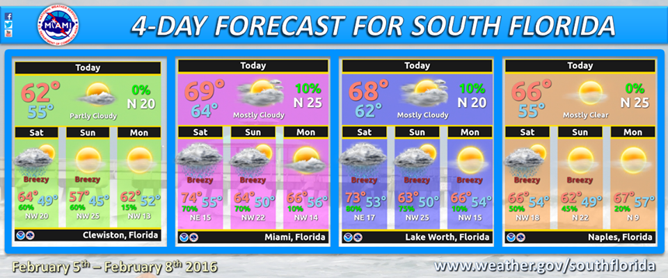
But rain will return late on Friday and early on Saturday as that front oozes north again. Saturday morning temperatures will be in the low 60s, but some sun in the afternoon will allow highs to reach the mid 70s. Then another front sweeps through, bringing more showers Saturday night and early Sunday.
Colder air will work in, and that will be the story for Sunday and much of next week, with cold mornings and highs in the 60s — at least 10 degrees below normal for February. Sunday’s highs will reach the upper 60s, while Monday morning will see lows in the upper 40s to low 50s and afternoon highs in the mid 60s.

Look for this pattern to last through Wednesday.
By Donna Thomas, SouthFloridaReporter.com Meteorologist, Feb. 5, 2016
[/vc_message]Disclaimer
Artificial Intelligence Disclosure & Legal Disclaimer
AI Content Policy.
To provide our readers with timely and comprehensive coverage, South Florida Reporter uses artificial intelligence (AI) to assist in producing certain articles and visual content.
Articles: AI may be used to assist in research, structural drafting, or data analysis. All AI-assisted text is reviewed and edited by our team to ensure accuracy and adherence to our editorial standards.
Images: Any imagery generated or significantly altered by AI is clearly marked with a disclaimer or watermark to distinguish it from traditional photography or editorial illustrations.
General Disclaimer
The information contained in South Florida Reporter is for general information purposes only.
South Florida Reporter assumes no responsibility for errors or omissions in the contents of the Service. In no event shall South Florida Reporter be liable for any special, direct, indirect, consequential, or incidental damages or any damages whatsoever, whether in an action of contract, negligence or other tort, arising out of or in connection with the use of the Service or the contents of the Service.
The Company reserves the right to make additions, deletions, or modifications to the contents of the Service at any time without prior notice. The Company does not warrant that the Service is free of viruses or other harmful components.


")
")


