

 After a week of tropical rains, South Florida is ready for some early September sun with a sprinkling of our typical afternoon storms — and that’s in the forecast for the long weekend. Look for sun and clouds, highs in the low 90s, and a few passing afternoon storms on Friday. The Naples and Marco Island areas will wider storm coverage than areas on the east coast on Friday, and the risk of dangerous rip currents will remain high at the Gulf beaches, and minor coastal flooding is still possible in spots.
 Saturday features sun, clouds, highs in the low sticky 90s along the east coast and in the upper 80s on the Gulf Coast, and afternoon storms — just stray storms in Miami-Dade and Broward but a few more storms along the Gulf coast and in the interior. The risk of dangerous rip currents will be increasing at the Atlantic beaches throughout the holiday weekend.
Sunday will bring more sun and clouds, highs in the sweltering low 90s, and a few passing storms throughout South Florida. Labor Day will be mostly dry in Miami-Dade and Broward, with just a passing afternoon storm possible, and highs will be in the muggy low 90s.
Look for passing showers and storms along the Gulf coast on Monday, and with highs around 90 degrees. The workweek begins on Tuesday with sun and clouds, highs around 90 degrees, and a passing afternoon storm or two in east coast metro areas and more widespread afternoon storms along the Gulf coast.

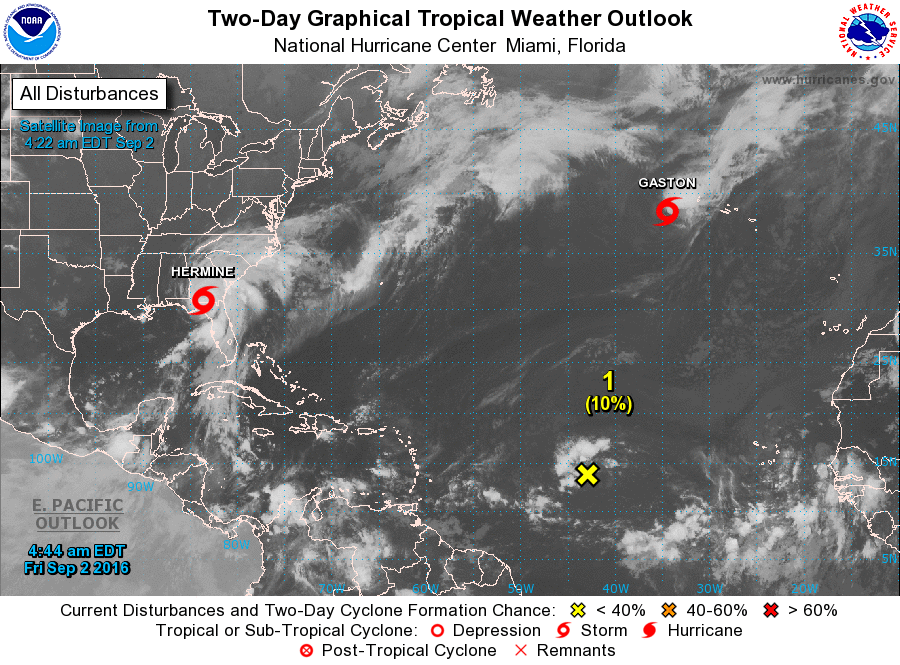
Hermine made landfall as a category 1 hurricane near St. Marks, Florida, around 1:30 am Friday — the first hurricane to make landfall in Florida since Wilma in 2005. At 5 am Friday, now Tropical Storm Hermine was located near 30.8 North, 83.6 West, about 20 miles west of Valdosta, Georgia. Hermine was moving north-northeast at 14 miles per hour and had top winds of 70 miles per hour. It is bringing flooding rain and damaging winds to northern and central Florida and southern Georgia, and coastal and storm surge flooding continues in the region. Hermine is forecast to move into the Carolinas before exiting into Atlantic coastal waters. A tropical storm warning is up for the Georgia and Carolina coasts, and a tropical storm watch is in effect northward to Long Island. Hermine’s threats to the southeast coast include heavy rain, gusty winds, coastal flooding, and beach erosion.
 Elsewhere in the tropics, Gaston is racing east-northeastward toward the Azores and should affect the area on Friday into Saturday. A tropical storm warning is in effect for the western and central Azores. And the wave in the central Atlantic is encountering dry air and has a low chance of developing into a depression over the next several days.
Disclaimer
Artificial Intelligence Disclosure & Legal Disclaimer
AI Content Policy.
To provide our readers with timely and comprehensive coverage, South Florida Reporter uses artificial intelligence (AI) to assist in producing certain articles and visual content.
Articles: AI may be used to assist in research, structural drafting, or data analysis. All AI-assisted text is reviewed and edited by our team to ensure accuracy and adherence to our editorial standards.
Images: Any imagery generated or significantly altered by AI is clearly marked with a disclaimer or watermark to distinguish it from traditional photography or editorial illustrations.
General Disclaimer
The information contained in South Florida Reporter is for general information purposes only.
South Florida Reporter assumes no responsibility for errors or omissions in the contents of the Service. In no event shall South Florida Reporter be liable for any special, direct, indirect, consequential, or incidental damages or any damages whatsoever, whether in an action of contract, negligence or other tort, arising out of or in connection with the use of the Service or the contents of the Service.
The Company reserves the right to make additions, deletions, or modifications to the contents of the Service at any time without prior notice. The Company does not warrant that the Service is free of viruses or other harmful components.
")


")

