Home Weather Drying Out Here, Busy in the Tropics

Drying Out Here, Busy in the Tropics

drying out

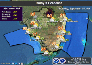
image4South Florida will be drying out on Thursday as the tropics become very busy. Here at home, we’ll see some early showers in the Keys on Thursday, and some afternoon storms will form as the Atlantic and Gulf sea breezes push into the interior regions. Just a stray storm will pop up in the metro areas, and highs will be around 90 degrees.

The drier air will settle in on Friday, and any image6isolated storms that develop will be mostly in the interior and along the Gulf coast. Friday’s highs will be around the 90 degree mark. The pattern continues over the weekend.
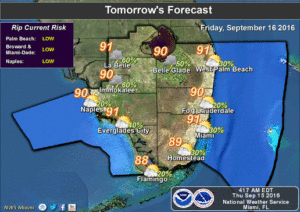
Look for sun and clouds, highs in the low 90s, and a few afternoon storms in spots on Saturday and Sunday.

Monday will bring a few early east coast showers, afternoon storms in spots, and highs near 90 degrees.
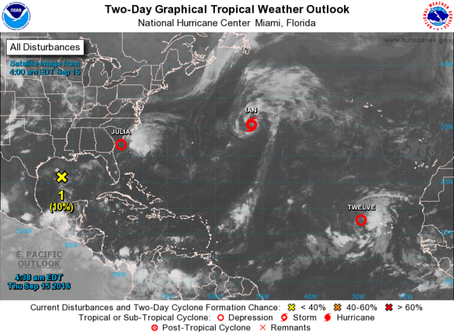
drying outThere’s plenty to talk about in the tropics. Julia is now a tropical depression as it lingers just off the Georgia and South Carolina coast. At 5 am Thursday, Julia was located near 32.0 North, 79.6 West, about 60 miles south-southeast of Charleston, South Carolina. Julia was crawling east at 2 miles per hour and had maximum sustained winds of 35 miles per hour. Julia is not expected to move much over the next couple of days, and it will bring rain and gusty winds to coastal areas of extreme northeastern Florida, Georgia and the Carolinas.

The wave near the Cape Verde Islands is now Tropical Depression #12. At 5 am Thursday, it was located near 17.9 North, 29.3 West, and was moving west at 16 miles per hour. Maximum sustained winds were 35 miles per hour. It will struggle with wind shear and dry air for a while but is expected to become a tropical storm. We’ll watch this one as it approaches the Lesser Antilles early next week.

Elsewhere, Tropical Storm Ian is accelerating to the north-northeast at 20 miles per hour. It still has top winds of 50 miles per hour but is beginning its transition to an extra-tropical cyclone. It will remain in the central Atlantic. And in the northwestern Gulf of Mexico, an area of cloudiness and showers has a low chance of developing into a depression over the next few days.

[vc_message message_box_style=”3d” message_box_color=”turquoise”]By Donna Thomas, SouthFloridaReporter.com Meteorologist, Sept. 15, 2016 [/vc_message]
Donna Thomas has studied hurricanes for two decades. She holds a PhD in history when her experience with Hurricane Andrew ultimately led her to earn a degree in broadcast meteorology from Mississippi State University. Donna spent 15 years at WFOR-TV (CBS4 in Miami-Fort Lauderdale), where she worked as a weather producer with hurricane experts Bryan Norcross and David Bernard. She also produced hurricane specials and weather-related features and news coverage, as well as serving as pool TV producer at the National Hurricane Center during the 2004 and 2005 seasons. Donna also served as a researcher on NOAA's Atlantic Hurricane Database Reanalysis Project. Donna specializes in Florida's hurricane history.