

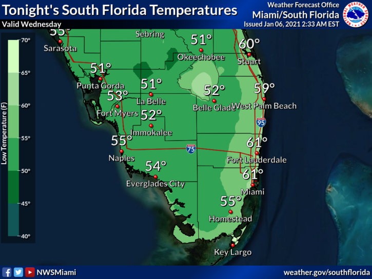
 Wednesday starts with a chilly morning as temperatures dip into the upper 40s and low 50s. The rest of the day will be sunny and cool. A moderate risk of dangerous rip currents is in place along the Palm Beach County coast. Highs on Wednesday will be mostly in the low 70s, with a few locations in the east coast metro area briefly reaching the mid-70s.
LIVE RADAR 24/7 (Click Here Then Press Play)
Thursday will begin with lows ranging from the mid-50s to the low 60s. Then we’ll see a mix of sun and clouds with the slight chance of an east coast shower. Thursday’s highs will be in the mid-70s.
Friday will be breezy with good sun and a few clouds as a front moves in. Friday’s highs will be in the low 70s along the Gulf coast and the mid-70s in the east coast metro area.

Saturday will be mostly sunny but with a cool breeze. Saturday’s highs will be in the upper 60s.
Sunday will feature a chilly morning and lots of sun later in the day. Highs on Sunday will be near 70 degrees.
Disclaimer
The information contained in South Florida Reporter is for general information purposes only.
The South Florida Reporter assumes no responsibility for errors or omissions in the contents of the Service.
In no event shall the South Florida Reporter be liable for any special, direct, indirect, consequential, or incidental damages or any damages whatsoever, whether in an action of contract, negligence or other tort, arising out of or in connection with the use of the Service or the contents of the Service. The Company reserves the right to make additions, deletions, or modifications to the contents of the Service at any time without prior notice.
The Company does not warrant that the Service is free of viruses or other harmful components


