

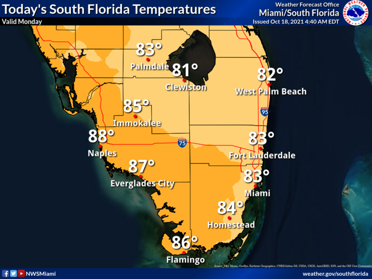
 Monday features breezy conditions, plenty of sun, and lower humidity in the wake of an early autumn front. A stray east coast shower is possible on the ocean breeze. A high risk of dangerous rip currents is in place at the Atlantic beaches. Highs on Monday will be in the mid-80s in the east coast metro area and will briefly hit the upper 80s along the Gulf coast.
LIVE RADAR 24/7 (Click Here Then Press Play)
Tuesday will start with mild temperatures in the morning, lots of sun, and a brisk and sometimes gusty breeze. A high risk of dangerous rip currents remains at the Atlantic beaches. Tuesday’s highs will be in the mid-80s in the east coast metro area and the upper 80s along the Gulf coast.
Wednesday will bring good sun, a brisk breeze, and some afternoon showers near the east coast. Wednesday’s highs will be mostly in the upper 80s.

Thursday will feature good sun, clouds at times, and some mid to late afternoon showers on the breeze. Thursday’s highs will be in the upper 80s.
Friday’s forecast calls for a mix of sun and clouds alternating with periods of showers. Highs on Friday will be mostly in the mid-80s.
The tropical Atlantic is quiet.
Disclaimer
The information contained in South Florida Reporter is for general information purposes only.
The South Florida Reporter assumes no responsibility for errors or omissions in the contents of the Service.
In no event shall the South Florida Reporter be liable for any special, direct, indirect, consequential, or incidental damages or any damages whatsoever, whether in an action of contract, negligence or other tort, arising out of or in connection with the use of the Service or the contents of the Service. The Company reserves the right to make additions, deletions, or modifications to the contents of the Service at any time without prior notice.
The Company does not warrant that the Service is free of viruses or other harmful components


