Friday is off to a stormy start
Friday features storms and showers as a front moves in. Heavy rainfall is likely, and localized flooding is possible. A flood advisory is in effect Friday morning for portions of southern and central Miami-Dade. Strong storms are possible, especially in the afternoon into the evening. A high risk of dangerous rip currents is in place along the Palm Beach County coast and at the Gulf beaches, and there’s a moderate rip current risk at the beaches of Miami-Dade and Broward. Minor coastal flooding is possible near high tides on Friday and into the weekend. Weatherwise, this would be a good day to stay home if you can. Friday’s highs will be in the low 80s.
LIVE RADAR 24/7 (Click Here Then Press Play)
Saturday morning will see lingering showers and a few storms in spots. Then look for clearing skies and a brisk breeze. An elevated rip current risk will be in place at South Florida’s beaches. Daylight Saving Time ends early on Sunday, so set your clocks one hour back before going to sleep on Saturday night. Saturday’s highs will be mostly in the upper 70s in the east coast metro area and the mid-70s along the Gulf coast.
Sunday will be off to a cool start, with lows mostly in the upper 50s. Then the day will be sunny and breezy. Sunday’s highs will be in the mid-70s.
Monday will feature another chilly start in the upper 50s and low 60s. Then we” see lots of sun with a cool and gusty breeze. Monday’s highs will be in the upper 70s.
Tuesday’s forecast calls for another cool morning and sunny skies throughout the day. Highs on Tuesday will be in the low 80s.
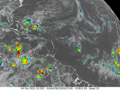
Tropical Storm Wanda continues to wander in the central Atlantic. At 5 am, Wanda was located near 41.8 North, 38.0 West, about 640 miles west-northwest of the Azores. Maximum sustained winds were 50 miles per hour, and Wanda was moving east-southeast at 6 miles per hour. This tenacious tropical storm will finally accelerate into colder waters early next week.
Disclaimer
The information contained in South Florida Reporter is for general information purposes only.
The South Florida Reporter assumes no responsibility for errors or omissions in the contents of the Service.
In no event shall the South Florida Reporter be liable for any special, direct, indirect, consequential, or incidental damages or any damages whatsoever, whether in an action of contract, negligence or other tort, arising out of or in connection with the use of the Service or the contents of the Service. The Company reserves the right to make additions, deletions, or modifications to the contents of the Service at any time without prior notice.
The Company does not warrant that the Service is free of viruses or other harmful components


