

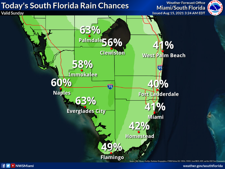
 Sunday features plenty of clouds, and periods of showers and storms and a brisk breeze. Heavy rain is possible, and a flood watch remains in effect. A high risk of dangerous rip currents is in place at the Atlantic beaches, and there’s a moderate rip current risk along the Gulf coast. Highs on Sunday will be mostly in the upper 80s.
LIVE RADAR 24/7 (Click Here Then Press Play)
Monday will bring some sun, more clouds, and periods of showers and storms, especially in the afternoon. Monday’s highs will be near 90 degrees.
Tuesday will feature a mix of sun and clouds with a few morning showers. Look for showers and storms to develop in the afternoon. Tuesday’s highs will be in the low 90s.

Wednesday’s weather will depend on the track and strength of Tropical Storm Grace. For now, we’ll say Wednesday will see periods of showers and storms on a building ocean breeze. Wednesday’s highs will be in the low 90s.
Thursday’s forecast will again depend on Grace. For now, we’ll say that Thursday will be windy with periods of heavy rain from passing showers and storms. . Highs on Thursday will be near 90 degrees.
 In the busy tropics, Fred degenerated into an open wave but is redeveloping on Sunday and is expected to regain tropical storm strength. At 5 am, Fred was located near 24.4 North, 84.6 West, about 425 south-southeast of Pensacola. Maximum sustained winds were 40 miles per hour (but there was not a closed circulation yet). Fred was moving north-northwest at 8 miles per hour. A tropical storm watch is in effect for portions of the Florida panhandle. Fred is forecast to reach the northern Gulf coast very early on Tuesday morning.
 To the east, Tropical Storm Grace was disorganized early Sunday — but we’ll need to watch it closely. At 5 am, Grace was located near 16.9 North, 64.4 West, about 150 miles southeast of San Juan, Puerto Rico. Maximum sustained winds were 40 miles per hour, and Grace was moving west-northwest at 16 miles per hour. Tropical storm warnings are up for Puerto Rico, the U.S. Virgin Islands, portions of the coast of the Dominican Republic, Sint Maarten, St. Martin and St. Barthelemy, and Saaba and Sint Eustatius, A tropical storm watch is in effect for the Haitian coast and for the northern coast of the Dominican Republic. Grace is expected to follow a track very similar to Fred’s. As with Fred, Grace’s future strength will depend on its interaction with Hispaniola. At 5 am on Sunday, the Florida Keys and the Gulf coast were in the 4-to-5-day “cone,” so we’ll need to keep updated on Grace and be ready to take any necessary actions.
Elsewhere in the overheated tropics, a low about 200 miles north-northeast of Bermuda has a low chance of becoming a depression during the next couple of days. By Tuesday, conditions will be less favorable for development.
Disclaimer
Artificial Intelligence Disclosure & Legal Disclaimer
AI Content Policy.
To provide our readers with timely and comprehensive coverage, South Florida Reporter uses artificial intelligence (AI) to assist in producing certain articles and visual content.
Articles: AI may be used to assist in research, structural drafting, or data analysis. All AI-assisted text is reviewed and edited by our team to ensure accuracy and adherence to our editorial standards.
Images: Any imagery generated or significantly altered by AI is clearly marked with a disclaimer or watermark to distinguish it from traditional photography or editorial illustrations.
General Disclaimer
The information contained in South Florida Reporter is for general information purposes only.
South Florida Reporter assumes no responsibility for errors or omissions in the contents of the Service. In no event shall South Florida Reporter be liable for any special, direct, indirect, consequential, or incidental damages or any damages whatsoever, whether in an action of contract, negligence or other tort, arising out of or in connection with the use of the Service or the contents of the Service.
The Company reserves the right to make additions, deletions, or modifications to the contents of the Service at any time without prior notice. The Company does not warrant that the Service is free of viruses or other harmful components.


")


