

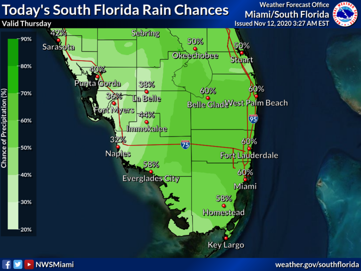
 Thursday features a brisk and sometimes gusty breeze, periods of showers and storms, and a mix of sun and clouds as we feel the lingering effects of Tropical Storm Eta. Minor coastal flooding is possible along the Gulf coast. The flood watch remains in effect in the east coast metro area through Thursday evening. A high risk of dangerous rip currents remains at the Atlantic coast through Friday evening and at the Gulf Coast through Thursday evening. Highs on Thursday will be in the mid-80s.
LIVE RADAR 24/7 (Click Here Then Press Play)
Friday will be mostly sunny and breezy, with a few passing showers and storms. Friday’s highs will be in the mid-80s.
Saturday will feature lots of sun and a much gentler ocean breeze, Saturday’s highs will be in the mid-80s.

Sunday will be another sunny day with a mild ocean breeze. Sunday’s highs will be in the mid-80s.
Monday’s forecast includes good sun with a few clouds and quick showers. Highs on Monday will be in the mid-80s again.
 Tropical Storm Eta made landfall near Cedar Key early Thursday morning. Shortly after 4 am, Eta was located near 29.2 North, 83.0 West, and was moving northeast at 13 miles per hour. Maximum sustained winds were 50 miles per hour. A tropical storm warning is in effect from Longboat Key to the Suwannee River and along the Atlantic coast from the Flagler/Volusia county line to St. Andrews Sound, Georgia. Eta is forecast to move across northeast Florida and into the Atlantic later on Thursday.
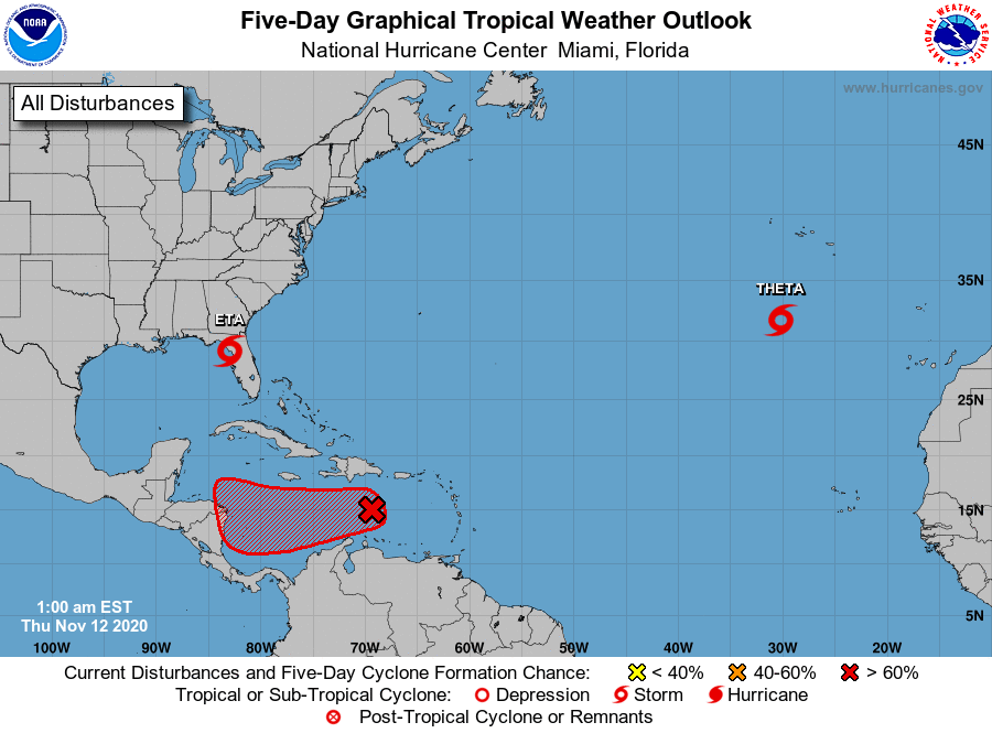 Elsewhere, Tropical Storm Theta was about 470 miles south-southwest of the Azores at 4 am on Thursday. Theta was moving east-northeast at 12 miles per hour and had maximum sustained winds of 65 miles per hour. Thankfully, this one is not expected to affect land. And the wave moving into the central Caribbean has a high chance of developing as it moves westward on its way to Central America. In the meantime, the wave is bringing heavy rain to Puerto Rico, the Virgin Islands, and part of Hispaniola.
Disclaimer
Artificial Intelligence Disclosure & Legal Disclaimer
AI Content Policy.
To provide our readers with timely and comprehensive coverage, South Florida Reporter uses artificial intelligence (AI) to assist in producing certain articles and visual content.
Articles: AI may be used to assist in research, structural drafting, or data analysis. All AI-assisted text is reviewed and edited by our team to ensure accuracy and adherence to our editorial standards.
Images: Any imagery generated or significantly altered by AI is clearly marked with a disclaimer or watermark to distinguish it from traditional photography or editorial illustrations.
General Disclaimer
The information contained in South Florida Reporter is for general information purposes only.
South Florida Reporter assumes no responsibility for errors or omissions in the contents of the Service. In no event shall South Florida Reporter be liable for any special, direct, indirect, consequential, or incidental damages or any damages whatsoever, whether in an action of contract, negligence or other tort, arising out of or in connection with the use of the Service or the contents of the Service.
The Company reserves the right to make additions, deletions, or modifications to the contents of the Service at any time without prior notice. The Company does not warrant that the Service is free of viruses or other harmful components.


")
")
")


")
")
")