

 Sunday features lots of sun, a few clouds, and passing showers at times, mostly in the afternoon. A moderate risk of dangerous rip currents is in place at the Atlantic beaches. Highs on Sunday will be mostly in the upper 80s.
LIVE RADAR 24/7 (Click Here Then Press Play)
Monday will be mostly sunny and very breezy. Look for a few east coast showers as well. Monday’s highs will be in the low 80s.
Tuesday will feature plenty of sun and windy conditions. Tuesday’s highs will be near 80 degrees.

Wednesday will continue the pattern of good sun and gusty winds. Wednesday’s highs will be in the low 80s.
Thursday’s forecast calls for good sun and some showers and storms on a very strong breeze. Highs on Thursday will be in the mid-80s.
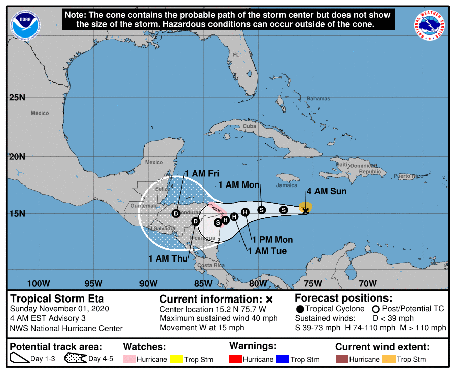 In the tropics, the disturbance in the Caribbean that we’ve been watching went from a depression to Tropical Storm Eta. At 5 am Sunday, Eta was located near 15.2 North, 75.7 West, about 500 miles east of the border of Nicaragua and Honduras. Maximum sustained winds were 40 miles per hour, and Eta was moving west at 15 miles per hour. A hurricane watch is in effect for portions of the Nicaraguan and Honduran coasts. Eta is forecast to strengthen prior to landfall on Tuesday. Computer models are not in agreement with what happens to Eta (or its remnants) after that, so we’ll watch it closely.
Disclaimer
Artificial Intelligence Disclosure & Legal Disclaimer
AI Content Policy.
To provide our readers with timely and comprehensive coverage, South Florida Reporter uses artificial intelligence (AI) to assist in producing certain articles and visual content.
Articles: AI may be used to assist in research, structural drafting, or data analysis. All AI-assisted text is reviewed and edited by our team to ensure accuracy and adherence to our editorial standards.
Images: Any imagery generated or significantly altered by AI is clearly marked with a disclaimer or watermark to distinguish it from traditional photography or editorial illustrations.
General Disclaimer
The information contained in South Florida Reporter is for general information purposes only.
South Florida Reporter assumes no responsibility for errors or omissions in the contents of the Service. In no event shall South Florida Reporter be liable for any special, direct, indirect, consequential, or incidental damages or any damages whatsoever, whether in an action of contract, negligence or other tort, arising out of or in connection with the use of the Service or the contents of the Service.
The Company reserves the right to make additions, deletions, or modifications to the contents of the Service at any time without prior notice. The Company does not warrant that the Service is free of viruses or other harmful components.

")
")


")

")
")

. Hazardous marine and beach conditions will develop with the frontal passage and linger through the week)