

As the spring of 2026 draws to a close, the United States stands on the precipice of a summer defined by meteorological volatility. According to the latest long-range outlook from AccuWeather, a combination of rapidly developing oceanic patterns and atmospheric pressure shifts will create a “summer of weather extremes.” Central to this forecast is the emergence of a strengthening El Niño, a phenomenon that is expected to significantly alter the storm track and temperature gradients across North America.
The Return of El Niño: A Meteorological Engine
The primary driver of the 2026 summer forecast is the transition into an El Niño phase. AccuWeather long-range experts have observed sea-surface temperatures in the central and eastern tropical Pacific rising at a pace that suggests a “Super El Niño” is not out of the question, with current probabilities sitting between 15% and 20% for reaching that threshold by the end of the year.
While the full atmospheric response to El Niño often lags behind the initial warming of the waters, the influence is expected to be felt throughout the summer months. Paul Pastelok, AccuWeather’s Lead Long-Range Expert, notes that this specific cycle will contribute to a stark divide in the nation’s weather. “This summer will likely be remembered for weather extremes,” Pastelok stated. “A quickly developing El Niño is expected to help shape the summer pattern by influencing the tropics and shifting storm tracks.”

This shift typically results in a more active southern jet stream, which can lead to increased moisture and storminess across the southern and central U.S., while simultaneously contributing to high-pressure ridges that trap heat in the West and Northwest.
A Nation Divided: Regional Heat Projections
 For much of the country, the summer of 2026 will be characterized by temperatures that sit well above historical averages. However, the timing and intensity of this heat will vary significantly by region.
The Pacific Northwest and Great Basin
The most consistent and intense heat is projected for the Northwest, the Great Basin, and the central Rockies. Forecasters anticipate temperatures in these regions could average four to six degrees above historical norms over the 90-day summer period. Major metropolitan areas in the Northwest, which historically enjoy milder summers, are at a higher risk for prolonged heat waves reaching into the 90s and even triple digits.
Pastelok warns that these regions should prepare for higher energy costs early in the season. “Get ready for a hot summer and higher power bills in the Northwest,” he explained, adding that while El Niño plays a role, local factors like high pressure and drier-than-average soil will be the primary drivers of the initial heat surges in this corner of the country.
The Northeast and Great Lakes
In contrast to the rapid onset of heat in the West, the Northeast, Great Lakes, and Appalachians are expected to see a slower transition to steady summer warmth. Residents in these areas may experience a “back-and-forth” pattern during June, with occasional cold fronts providing temporary relief from the encroaching humidity.
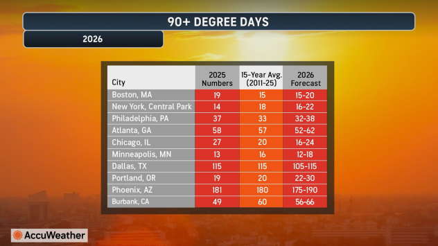
However, this slow start does not mean the region will escape the heat. AccuWeather predicts that by August, a late-summer surge of intense heat and humidity will likely take hold. Cities such as Boston, New York City, and Philadelphia are projected to see 90-degree days that meet or exceed historical averages, largely driven by this late-season push.
The South and California
The southern tier of the country, from California through the Gulf Coast, will likely face stretches of intense, record-challenging heat. California, in particular, may see near-record temperatures as early as June. The “Urban Heat Island” effect will be a major concern for cities like Los Angeles, Phoenix, and Houston, where concrete and asphalt trap heat, preventing nighttime temperatures from dropping significantly. “Record heat during the day makes headlines, but warm nights are just as impactful,” Pastelok said, noting the increased strain on electrical grids and public health when the body cannot cool down overnight.
Severe Weather and the Threat of “Inland Hurricanes”
While the heat will be the most widespread story, the potential for destructive severe weather remains a critical concern for the central and eastern U.S.
The Shift of Tornado Alley
In June and July, the primary corridor for severe thunderstorms and tornadoes is expected to focus on the Plains, extending into the Midwest and Ohio Valley. AccuWeather experts suggest that the number of tornadoes could be near or above average during these months. As the season progresses into late July and August, the threat of severe weather is forecast to shift further east toward the Mid-Atlantic and Northeast.
The Risk of Derechos
One of the most dangerous prospects for the 2026 season is the potential for derechos—long-lived, widespread wind storms that are often described as “inland hurricanes.” These systems can produce wind gusts exceeding 100 mph, causing massive power outages and structural damage over hundreds of miles. The atmospheric setup this summer—characterized by extreme heat in the West and moisture-laden air from the Gulf of Mexico—provides the perfect ingredients for these thunderstorm clusters to develop in the north-central Plains and Midwest.
Hydrological Extremes: Drought and Flooding
The 2026 forecast highlights a growing moisture disparity across the continent.
Worsening Drought and Wildfires
Drought conditions are expected to intensify across the Northwest and Great Basin, thereby elevating the risk of destructive wildfires. While the Southwest may see some improvement in drought conditions due to an influx of moisture from the developing El Niño and the potential for a robust monsoon season, the Northwest remains a “bullseye” for dry conditions.
Flash Flooding Threats
On the opposite end of the spectrum, flash flooding is expected to be a frequent threat from Texas through the Ohio Valley. Repeated clusters of thunderstorms are likely to follow a similar track, leading to saturated soils and rapid runoff. Texas, in particular, may face significant flood risks early in the summer. Additionally, the Southwest and southern Rockies could experience mudslides if sudden surges of moisture from the eastern Pacific interact with the region’s rugged terrain.
The Tropical Connection and Agricultural Impacts
Despite the development of El Niño—which typically acts to suppress Atlantic hurricane activity by increasing vertical wind shear—AccuWeather warns that the U.S. coastline is not out of the woods. Warm water temperatures in the Atlantic basin remain a wildcard. The risk of direct impacts remains elevated for the central and eastern Gulf Coast, the Southeast, and the Carolinas.
Agriculture will also bear the brunt of these extremes. Drier stretches in the northern Plains and Upper Midwest could stress major crops, while the excess moisture in the Ohio Valley may lead to planting delays or crop damage from standing water.
Summary of the Season
The summer of 2026 is shaping up to be a season of contrasts. As Paul Pastelok summarizes, “The nation could be divided by weather extremes this summer. We may see dramatically different conditions happening at the same time, with flash flooding in one region while others deal with extreme heat, drought, and wildfires.”
For residents across the United States, preparation is key. Whether it is bracing for record-breaking heat in the Northwest, preparing for severe derecho events in the Midwest, or monitoring the potential for late-season tropical development on the East Coast, the message from forecasters is clear: 2026 will be a summer that tests the limits of the nation’s infrastructure and the resilience of its citizens.
Sources and Links:
- AccuWeather: Summer of Weather Extremes Expected Across America: Heat Waves, Drought, Severe Storms, Flooding and Wildfires
- AccuWeather Video: Summer forecast 2026: Heat, Severe Storms to Shape the Season as El Niño Strengthens
- Men’s Journal: El Niño’s Development Will Bring Severe Weather Across the Country This Summer
Disclaimer
Artificial Intelligence Disclosure & Legal Disclaimer
AI Content Policy.
To provide our readers with timely and comprehensive coverage, South Florida Reporter uses artificial intelligence (AI) to assist in producing certain articles and visual content.
Articles: AI may be used to assist in research, structural drafting, or data analysis. All AI-assisted text is reviewed and edited by our team to ensure accuracy and adherence to our editorial standards.
Images: Any imagery generated or significantly altered by AI is clearly marked with a disclaimer or watermark to distinguish it from traditional photography or editorial illustrations.
General Disclaimer
The information contained in South Florida Reporter is for general information purposes only.
South Florida Reporter assumes no responsibility for errors or omissions in the contents of the Service. In no event shall South Florida Reporter be liable for any special, direct, indirect, consequential, or incidental damages or any damages whatsoever, whether in an action of contract, negligence or other tort, arising out of or in connection with the use of the Service or the contents of the Service.
The Company reserves the right to make additions, deletions, or modifications to the contents of the Service at any time without prior notice. The Company does not warrant that the Service is free of viruses or other harmful components.


