

Tuesday features a brisk and gusty breeze, with more clouds than sun in the east coast metro area and the Keys and mostly sunny skies along the Gulf coast. A high risk of dangerous rip currents is in place at the Atlantic beaches through Wednesday evening. Highs on Tuesday will be in the low 80s in the East Coast metro area, the mid-80s along the Gulf Coast, and the upper-70s in the Keys.
Wednesday will bring some sun and more clouds on a gusty breeze to the East Coast metro area. The Gulf Coast and the Keys will see a mix of sun and clouds. A high risk of dangerous rip currents remains at the Atlantic beaches, and minor flooding near high tides is possible along the Atlantic coast. Wednesday’s highs will be mostly in the mid-80s on the mainland and in the low-80s in the Keys.
Thursday will feature lots of clouds and a bit of sun around South Florida. Look for a gusty breeze in the East Coast metro area and a few showers in the Keys. Expect an elevated risk of dangerous rip currents at the Atlantic beaches and minor flooding near high tides along the Atlantic coast. Thursday’s highs will be in the mid-80s on the mainland and the low-80s in the Keys.
Friday will be cloudy and rainy in the East Coast metro area, while the Gulf Coast and the Keys will be a mix of sun, clouds, and a few showers. Friday’s highs will be mostly in the mid-80s on the mainland and in the low-80s in the Keys.

Saturday’s forecast calls for mostly sunny skies with a few showers in the East Coast metro area. Look for lots of sun along the Gulf Coast and in the Keys. Highs on Saturday will be in the mid-80s on the mainland and the low-80s in the Keys.
The tropical Atlantic is quiet right now.
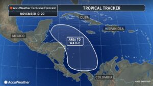 Caribbean for signs of tropical development in the coming weeks. Atmospheric conditions could support development through mid-November. If anything were to develop in the western portion of the Caribbean, it would likely move west toward Central America or Mexico due to easterly steering breezes. In addition, development time prior to landfall may limit the strength of such a storm.”
Disclaimer
Artificial Intelligence Disclosure & Legal Disclaimer
AI Content Policy.
To provide our readers with timely and comprehensive coverage, South Florida Reporter uses artificial intelligence (AI) to assist in producing certain articles and visual content.
Articles: AI may be used to assist in research, structural drafting, or data analysis. All AI-assisted text is reviewed and edited by our team to ensure accuracy and adherence to our editorial standards.
Images: Any imagery generated or significantly altered by AI is clearly marked with a disclaimer or watermark to distinguish it from traditional photography or editorial illustrations.
General Disclaimer
The information contained in South Florida Reporter is for general information purposes only.
South Florida Reporter assumes no responsibility for errors or omissions in the contents of the Service. In no event shall South Florida Reporter be liable for any special, direct, indirect, consequential, or incidental damages or any damages whatsoever, whether in an action of contract, negligence or other tort, arising out of or in connection with the use of the Service or the contents of the Service.
The Company reserves the right to make additions, deletions, or modifications to the contents of the Service at any time without prior notice. The Company does not warrant that the Service is free of viruses or other harmful components.


")
")
")


 Cold Sweat Ice Cream Features Peppers So Hot You Must Sign A Waiver Before Eating It.")