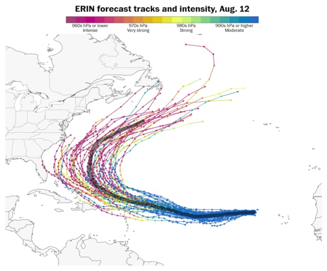
The storm was thousands of miles away east of the United States early Tuesday, but forecasters are carefully monitoring where it may head.
Although Erin’s long-term track is uncertain, two track scenarios appear more likely than the rest into next week:
- A northerly track into the western Atlantic Ocean would have the storm missing the Caribbean Islands and United States, but possibly affecting Bermuda.
- A more southerly track from the northern Caribbean to the Bahamas would put the Leeward Islands, East Coast and eastern Canada at risk of storm impacts.
Most storms take 8 to 12 days to cross the Atlantic — so any direct land impacts from Erin are unlikely until this weekend in the Caribbean, at the earliest.
Erin will encounter very warm ocean water north of the Caribbean Islands later this week, aiding in its likely intensification. These unusually warm waters have forecasters concerned about a heightened risk for impacts to the East Coast this hurricane season.
Disclaimer
The information contained in South Florida Reporter is for general information purposes only.
The South Florida Reporter assumes no responsibility for errors or omissions in the contents of the Service.
In no event shall the South Florida Reporter be liable for any special, direct, indirect, consequential, or incidental damages or any damages whatsoever, whether in an action of contract, negligence or other tort, arising out of or in connection with the use of the Service or the contents of the Service. The Company reserves the right to make additions, deletions, or modifications to the contents of the Service at any time without prior notice.
The Company does not warrant that the Service is free of viruses or other harmful components


