

The romantic glow of Valentine’s Day may be dimmed by dark clouds this year as a potent storm system prepares to sweep across the central and southeastern United States. While couples in the South contend with drenching rains and the threat of severe weather, residents in the Northeast are keeping a watchful eye on the horizon, where a thin margin of cold air could transform a rainy weekend into a wintry mess.
A Southern Soaking: Flood and Severe Risks
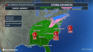 The storm is expected to organize late this week over the Southern Plains, gaining strength across Oklahoma, Texas, Missouri, Arkansas, and Louisiana. By Friday, the system will begin its eastward march, spreading a canopy of moisture into Virginia and down through Georgia and Florida over the weekend.
According to AccuWeather, the sheer volume of water associated with this system is significant. Widespread rainfall totals of 1–4 inches are forecast from the Texas coast through the Carolinas. While many landscapes can absorb this over 48 hours, AccuWeather warns that localized totals could reach an AccuWeather Local StormMax™ of 6 inches. This intense rainfall carries the risk of minor flooding in urban areas and along small streams, potentially disrupting Valentine’s Day travel and outdoor events.
Beyond the rain, a more volatile threat looms. On Saturday, the atmosphere is expected to become unstable from central Texas to western Mississippi. Meteorologists are tracking the potential for “severe weather clusters” capable of producing:

- Damaging wind gusts
- Large hail
- Flash flooding downpours
- Isolated tornadoes
The Northeast: A Forecast on the Bubble
While the South prepares for water, the Northeast is locked in a game of “wait and see.” The primary question for meteorologists is whether the storm will track far enough north to tap into a modest reservoir of cold air sitting over the interior.
“While there is not a large area of Arctic air to the north, there is enough cold air for some precipitation to be snow and ice,” says Dan DePodwin, AccuWeather Senior Director of Forecasting Operations. “At this time, the greatest risk for any snow and ice will be from the mid-Atlantic into southern portions of New England.”
The transition from rain to ice is a particular concern for the interior. DePodwin notes that the extensive snowpack across the Midwest and Northeast acts as a thermal buffer, often preventing warmer air from reaching the ground quickly.
“This can increase the risk of ice, especially when precipitation begins, even if the majority of the event is rain,” DePodwin explains. However, those in the “I-95 corridor”—specifically from Washington, D.C., to Boston—should breathe a sigh of relief regarding major accumulations. DePodwin suggests it likely won’t be cold enough for a blockbuster snow event in the coastal cities, though some slushy snow or ice remains possible from New York City to Boston.
Logistics and Infrastructure Constraints
The timing of the storm introduces a ripple effect for national logistics. Travel delays are highly likely across the Southern states, where heavy rain and thunderstorms frequently lead to ground and air traffic congestion.
Infrastructure is already under stress in the mid-country. Navigation on the upper Mississippi River remains closed due to extensive ice buildup. Conversely, farther south, low water levels continue to plague shipping lanes. This “dual-threat” of ice and low water, now combined with a significant rain event, adds a layer of complexity for supply chain managers trying to move goods through the heart of the country.
Looking West: California’s Monthly Dose in a Week
While the East deals with the Valentine’s Day system, a separate, perhaps more historic, weather pattern is brewing in the West. A series of Pacific storms is slated to slam into California beginning late this weekend and continuing well into next week.
The scale of this moisture is staggering. Bernie Rayno, AccuWeather Chief On-Air Meteorologist, warns: “It is possible the series of storms next week in California delivers close to an entire month’s worth of rain and snow. Multiple inches of rain will pour down in many areas, while feet of snow pile up in the Sierra Nevada.”
This influx of moisture is a double-edged sword. While it brings a much-needed boost to the Colorado River basin—where snowpack water levels in Colorado and Utah have been hovering near record minimums—the immediate impact will be hazardous. Commuters and freight operators on Interstate 80 over Donner Pass should prepare for feet of snow, while coastal regions face mudslides and flash flooding.
“With limited spring runoff available, [the low snowpack] could be a major problem for summer water concerns,” says AccuWeather Senior Meteorologist Brett Anderson. This upcoming deluge may provide a critical, if violent, correction to those water deficits.
The Late-February Flip: From Arctic to Aqueous
Looking further ahead, the bone-chilling cold that defined the early part of February is about to vanish. After a 17-day stretch where temperatures averaged more than 10 degrees below historical norms in the Central and Eastern states, a massive “thaw” is forecast for the final two weeks of the month.
Temperatures are expected to skyrocket to 10–20 degrees above average. Highs in the 40s and 50s will reach the Midwest, while the Southeast could see temperatures flirting with the 80-degree mark.
While this brings a welcome reprieve for heating bills, it introduces a new danger: Ice Jams. The persistent Arctic air has frozen many rivers, including the Susquehanna, Delaware, and Monongahela. As warmer temperatures arrive alongside potential rain, the rapid melting of snow and the breakup of river ice could trigger sudden, localized flooding.
Business and Operational Strategy
As we move through February, decision-makers are encouraged to remain agile. For the immediate Valentine’s Day weekend, the focus remains on the South’s flood risk and the Northeast’s potential for slick roads.
Moving into next week, the focus shifts to the West Coast’s supply chain stability. Finally, as the month closes, monitoring river gauges will be paramount for businesses situated along the major arteries of the Midwest and Northeast. The winter of 2026 is proving to be a season of extremes—shifting rapidly from ice-locked rivers to spring-like surges.
Disclaimer
Artificial Intelligence Disclosure & Legal Disclaimer
AI Content Policy.
To provide our readers with timely and comprehensive coverage, South Florida Reporter uses artificial intelligence (AI) to assist in producing certain articles and visual content.
Articles: AI may be used to assist in research, structural drafting, or data analysis. All AI-assisted text is reviewed and edited by our team to ensure accuracy and adherence to our editorial standards.
Images: Any imagery generated or significantly altered by AI is clearly marked with a disclaimer or watermark to distinguish it from traditional photography or editorial illustrations.
General Disclaimer
The information contained in South Florida Reporter is for general information purposes only.
South Florida Reporter assumes no responsibility for errors or omissions in the contents of the Service. In no event shall South Florida Reporter be liable for any special, direct, indirect, consequential, or incidental damages or any damages whatsoever, whether in an action of contract, negligence or other tort, arising out of or in connection with the use of the Service or the contents of the Service.
The Company reserves the right to make additions, deletions, or modifications to the contents of the Service at any time without prior notice. The Company does not warrant that the Service is free of viruses or other harmful components.


")

")


