

Wednesday features lots of hot sun in the morning on the mainland, but some showers and storms will develop in the afternoon, especially in the East Coast metro area. The Keys will see more clouds than sun and periods of showers. Expect a high risk of dangerous rip currents at the Atlantic beaches. Highs on Wednesday will be in the low 90s right at coasts and in the Keys, but the rest of South Florida will top out in the mid 90s — but it will feel like the triple digits everywhere, so stay hydrated and out of the sun.
Thursday will bring mostly sunny skies alternating with showers and storms on the mainland, while the Keys will see lots of clouds and some showers. Thursday’s highs will be mostly in the mid-90s along the East Coast and in the low 90s along the Gulf Coast and in the Keys.
Friday will feature a mix of hot sun and periods of showers and storms on the mainland. The Keys will see mostly sunny skies and a few showers in spots. Friday’s highs will be mostly in the mid-90s along the East Coast and in the low 90s along the Gulf Coast and in the Keys.
Saturday will be another day of hot sun, showers, and some storms on the mainland, while the Keys will see plenty of sun, a few clouds, and maybe a stray shower. Saturday’s highs will be mostly in the mid-90s in the East Coast metro area and the low-90s along the Gulf Coast and in the Keys.

Sunday’s forecast calls for a mix of sun, showers, and some storms on the mainland and mostly sunny skies in the Keys. Highs on Sunday will be mostly in the low 90s, with some suburban locations reaching the mid-90s.
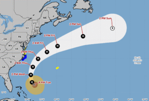 Hurricane Erin is growing in size as it makes its way well east of Florida. On Tuesday evening, Erin was located about 570 miles south-southeast of Cape Hatteras, North Carolina and 585 miles southwest of Bermuda. Maximum sustained winds were 105 miles per hour at that time as Erin moved north-northwest at 10 miles per hour.
A tropical storm warning is in effect for coastal North Carolina from Beaufort Inlet to Duck. There is a tropical storm watch north of Duck, North Carolina to Chincoteague, Virginia. Bermuda is also under a tropical storm watch.
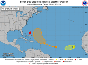 Elsewhere in the tropics, we’re keeping an eye on a low that’s forming in the central Atlantic. This feature currently has a medium chance of becoming a depression during the next few days as it moves west-northwest, reaching the Leeward Islands by the weekend. Recent computer model runs indicate a northward turn after that, but we’ll continue to track it. Finally, a wave in the eastern Atlantic has a low chance of developing during the next few days, after which it will enter an area unfavorable for tropical development.
Disclaimer
The information contained in South Florida Reporter is for general information purposes only.
The South Florida Reporter assumes no responsibility for errors or omissions in the contents of the Service.
In no event shall the South Florida Reporter be liable for any special, direct, indirect, consequential, or incidental damages or any damages whatsoever, whether in an action of contract, negligence or other tort, arising out of or in connection with the use of the Service or the contents of the Service. The Company reserves the right to make additions, deletions, or modifications to the contents of the Service at any time without prior notice.
The Company does not warrant that the Service is free of viruses or other harmful components


