

Thursday features lots of sun and a brisk and gusty breeze around South Florida. The risk of dangerous rip currents will increase at the Atlantic beaches on Thursday. Highs on Thursday will be mostly in the mid-80s in the East Coast metro area, in the upper 80s along the Gulf Coast, and in the mid-80s in the Keys.
Friday will bring breezy conditions, plenty of sun, and a few clouds at times. Expect an elevated risk of dangerous rip currents at the Atlantic beaches. Friday’s highs will be mostly in the mid-80s.
Saturday will feature breezy conditions and sunny skies on the mainland, but the east coast metro area could also see a shower or storm in spots during the afternoon. Look for clouds and showers in the Keys. Saturday’s highs will be in the mid-80s.
Sunday will see breezy conditions, mostly sunny skies, and some afternoon showers and storms in the East Coast metro area. The Gulf Coast will be mostly sunny with a gusty breeze. Clouds and showers will linger in the Keys. Sunday’s highs will be mostly in the mid-80s.

Monday’s forecast calls for good sun and a few clouds on the mainland, but the east coast metro area can also see some afternoon showers and storms in spots. Look for plenty of clouds and some showers in the Keys. Highs on Monday will be in the mid-80s.
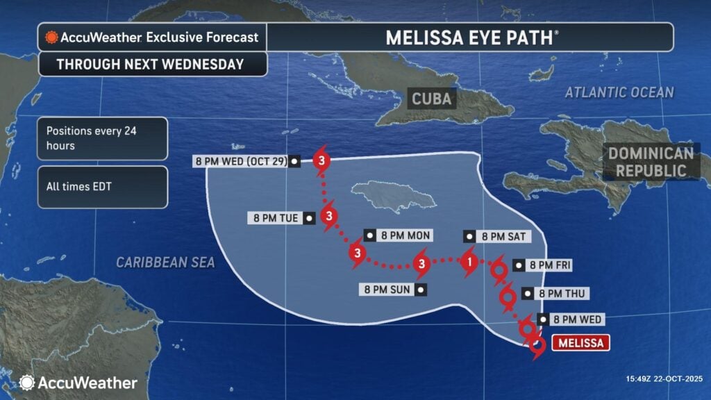
In the tropics, Tropical Storm Melissa is already bringing heavy rain and the threat of flash flooding and mudslides to Hispaniola and Jamaica. Early Wednesday evening, Melissa was about 300 miles southeast of Kingston, Jamaica and was moving west-northwest at 2 miles per hour. Maximum sustained winds were 50 miles per hour, but Meiissa is forecast to become a dangerous major hurricane.
There’s a hurricane watch for the southern coast of Haiti from the border with the Dominican Republic to Port-au-Prince, and there’s a tropical storm watch for Jamaica. Everyone will need to keep a close eye on Melissa and its highly uncertain future track.
Disclaimer
The information contained in South Florida Reporter is for general information purposes only.
The South Florida Reporter assumes no responsibility for errors or omissions in the contents of the Service.
In no event shall the South Florida Reporter be liable for any special, direct, indirect, consequential, or incidental damages or any damages whatsoever, whether in an action of contract, negligence or other tort, arising out of or in connection with the use of the Service or the contents of the Service. The Company reserves the right to make additions, deletions, or modifications to the contents of the Service at any time without prior notice.
The Company does not warrant that the Service is free of viruses or other harmful components


