

Sunday features a mix of sun, clouds, and mainly afternoon storms in the East Coast metro area. The Gulf Coast will see lots of sun in the morning, with clouds and storms developing in the afternoon and early evening. Highs on Sunday will be mostly in the low 90s, with a few suburban locations reaching the mid-90s. But it will feel about 10 degrees hotter, so stay hydrated and out of the sun.
Monday will bring mostly sunny skies with some storms to the East Coast metro area. The Gulf Coast will be sunny in the morning, but storms will return in the afternoon. Look for a mix of sun, clouds, and showers in the Keys. Monday’s highs will be in the low 90s.
Tuesday will feature a mix of sun, clouds, and mostly afternoon showers and storms on the mainland. The Keys will see clouds and showers. Tuesday’s highs will be in the low 90s.

Wednesday will be sunny and hot, with some storms developing in the afternoon. Wednesday’s highs will be mostly in the mid-90s on the mainland and the low 90s in the Keys.
Thursday’s forecast calls for a mix of hot sun, showers, and storms. Highs on Thursday will be in the low 90s along the coasts and in the Keys, and the mid-90s elsewhere in South Florida.
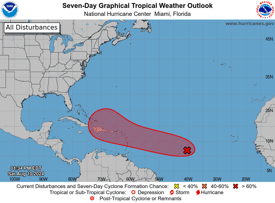 In the tropics, we’re watching the wave in the central Atlantic that now has a high chance of becoming a depression near or over the Lesser Antilles in a day or so. Although computer models currently indicate this feature could turn to the north well east of the Bahamas, it’s still early to say for sure — and we’ll keep an eye on it.
Disclaimer
Artificial Intelligence Disclosure & Legal Disclaimer
AI Content Policy.
To provide our readers with timely and comprehensive coverage, South Florida Reporter uses artificial intelligence (AI) to assist in producing certain articles and visual content.
Articles: AI may be used to assist in research, structural drafting, or data analysis. All AI-assisted text is reviewed and edited by our team to ensure accuracy and adherence to our editorial standards.
Images: Any imagery generated or significantly altered by AI is clearly marked with a disclaimer or watermark to distinguish it from traditional photography or editorial illustrations.
General Disclaimer
The information contained in South Florida Reporter is for general information purposes only.
South Florida Reporter assumes no responsibility for errors or omissions in the contents of the Service. In no event shall South Florida Reporter be liable for any special, direct, indirect, consequential, or incidental damages or any damages whatsoever, whether in an action of contract, negligence or other tort, arising out of or in connection with the use of the Service or the contents of the Service.
The Company reserves the right to make additions, deletions, or modifications to the contents of the Service at any time without prior notice. The Company does not warrant that the Service is free of viruses or other harmful components.


")


")
