

Saturday features mostly sunny skies with plenty of afternoon showers and storms on the mainland. Look for sun, clouds, and a few showers in the Keys. Highs on Saturday will be mostly in the low 90s, with a few inland locations reaching the mid-90s. But it will feel about 10 degrees hotter, so stay hydrated and out of the sun.
Sunday will bring morning sun and storms to the East Coast metro area, with plenty of showers in the afternoon and early evening. The Gulf Coast will see a mix of sun and storms. Look for clouds and showers in the Keys. Sunday’s highs will be in the low 90s.
Monday will feature partly sunny skies and afternoon storms in the East Coast metro area, while the Gulf Coast will see a mix of sun, clouds, and some afternoon storms. The Keys will be cloudy with showers. Monday’s highs will be mostly in the low 90s.

Tuesday will see sun and clouds with periods of showers and storms. Tuesday’s highs will be near 90 degrees on the mainland and in the upper 80s in the Keys.
Wednesday’s forecast calls for a mix of sun, clouds, showers, and storms. Highs on Wednesday will be mostly in the low 90s.
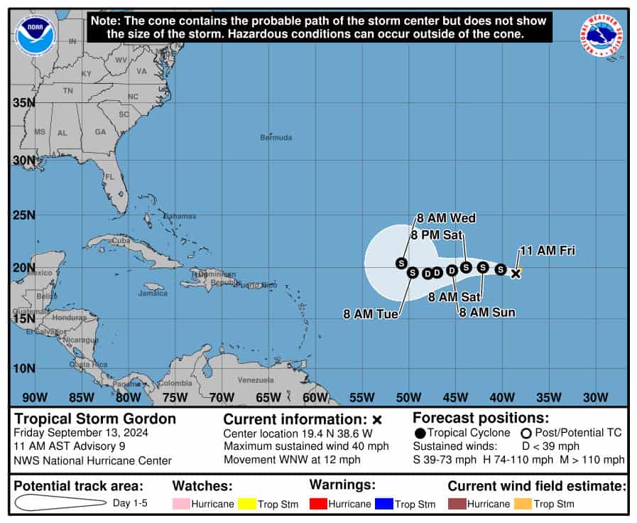
In the tropics, what was Tropical Depression # 7 became Tropical Storm Gordon late Friday morning. At that time, Gordon’s maximum sustained winds were 40 miles per hour, and it was moving west-northwest at 12 miles per hour. Gordon is forecast to have a tough time as it moves through the open waters of the central Atlantic for the next several days.
 What’s left of Francine continues to bring heavy rain and potentially flooding to portions of the Mississippi Valley.
Elsewhere, a non-tropical low is forming off the southeast U.S. coast This feature has a medium chance of becoming a subtropical or tropical depression as it moves to the northwest during the next several days. And the small low near the Leeward Islands is no longer expected to develop as it enters a region of hostile conditions.
Disclaimer
Artificial Intelligence Disclosure & Legal Disclaimer
AI Content Policy.
To provide our readers with timely and comprehensive coverage, South Florida Reporter uses artificial intelligence (AI) to assist in producing certain articles and visual content.
Articles: AI may be used to assist in research, structural drafting, or data analysis. All AI-assisted text is reviewed and edited by our team to ensure accuracy and adherence to our editorial standards.
Images: Any imagery generated or significantly altered by AI is clearly marked with a disclaimer or watermark to distinguish it from traditional photography or editorial illustrations.
General Disclaimer
The information contained in South Florida Reporter is for general information purposes only.
South Florida Reporter assumes no responsibility for errors or omissions in the contents of the Service. In no event shall South Florida Reporter be liable for any special, direct, indirect, consequential, or incidental damages or any damages whatsoever, whether in an action of contract, negligence or other tort, arising out of or in connection with the use of the Service or the contents of the Service.
The Company reserves the right to make additions, deletions, or modifications to the contents of the Service at any time without prior notice. The Company does not warrant that the Service is free of viruses or other harmful components.


")


")

")