

Friday features mostly sunny skies with periods of showers and storms in the east coast metro area. The Gulf Coast will be sunny in the morning with some showers and storms in the afternoon. The Keys will be cloudy with periods of showers and storms as tropical moisture begins to seep into South Florida. Expect an increasing risk of dangerous rip currents at the Atlantic beaches on Friday and through the weekend. Highs on Friday will be near 90 degrees in the East Coast metro area and the Keys and in the low 90s along the Gulf Coast.
Saturday will bring morning showers, afternoon storms, and a mix of sun and clouds to the East Coast metro area. The Gulf Coast will be partly cloudy with mainly afternoon and evening showers and storms. Look for clouds, showers, and some storms in the Keys. Heavy rain is possible in spots. Saturday’s highs will be in the upper 80s.
Sunday will feature clouds and some storms in the morning and lots of showers in the afternoon and evening. Heavy rain and localized flooding are possible. Sunday’s highs will be in the upper 80s.
Monday will be mostly cloudy with plenty of showers and a few storms in spots.
some sun, more clouds, and plenty of showers and storms. Localized flooding is possible with additional rainfall. Highs on Monday will be mostly in the mid-80s.

Tuesday’s forecast calls for another day of clouds, showers, and storms. Highs on Tuesday will be mostly in the mid-80s, with a few east coast locations reaching the upper 80s.
 In the tropics, we continue to watch a slowly-developing area of low pressure that’s now in the southern Gulf of Mexico. While the National Hurricane Center gives this feature a low chance of becoming a depression, it will bring heavy rain to portions of Mexico and to South Florida — and flooding will be a possibility this weekend and into next week. Computer models suggest that this feature could interact with a front, which in turn would impede tropical development. We’ll have to wait and see — and prepare for lots of rain.
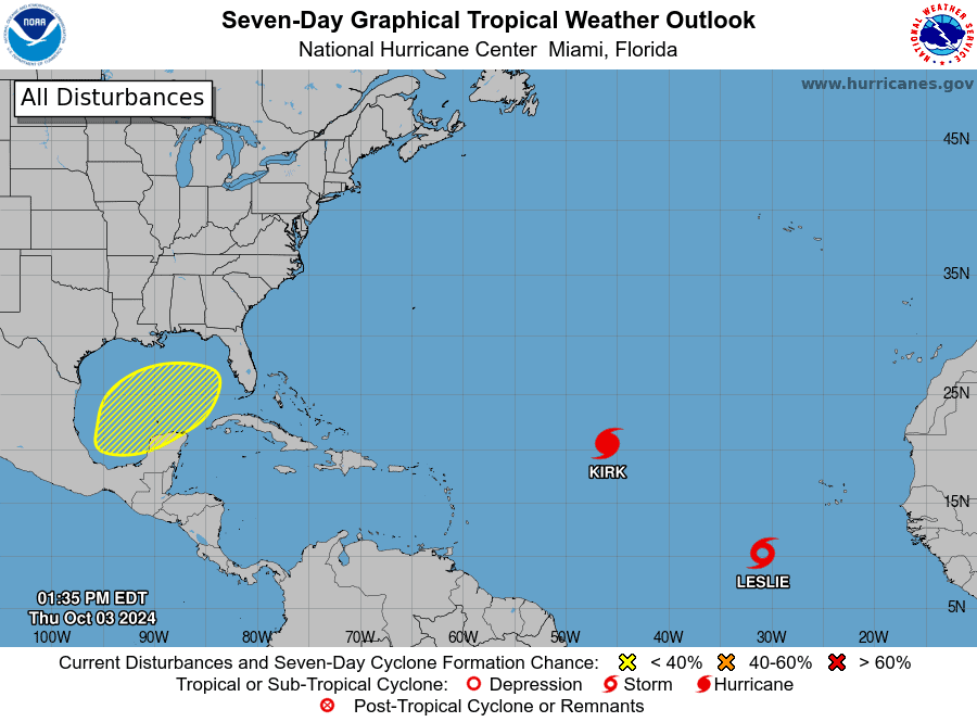 Elsewhere, Kirk is a major hurricane that is forecast to turn northward this weekend. While Kirk will remain in the open Atlantic, its swells will reach the U.S. east coast on Sunday or Monday, making for hazardous surf conditions and dangerous rip currents. Leslie is gaining strength in the central Atlantic and is expected to become a hurricane on Friday as it moves through the open ocean.
Disclaimer
Artificial Intelligence Disclosure & Legal Disclaimer
AI Content Policy.
To provide our readers with timely and comprehensive coverage, South Florida Reporter uses artificial intelligence (AI) to assist in producing certain articles and visual content.
Articles: AI may be used to assist in research, structural drafting, or data analysis. All AI-assisted text is reviewed and edited by our team to ensure accuracy and adherence to our editorial standards.
Images: Any imagery generated or significantly altered by AI is clearly marked with a disclaimer or watermark to distinguish it from traditional photography or editorial illustrations.
General Disclaimer
The information contained in South Florida Reporter is for general information purposes only.
South Florida Reporter assumes no responsibility for errors or omissions in the contents of the Service. In no event shall South Florida Reporter be liable for any special, direct, indirect, consequential, or incidental damages or any damages whatsoever, whether in an action of contract, negligence or other tort, arising out of or in connection with the use of the Service or the contents of the Service.
The Company reserves the right to make additions, deletions, or modifications to the contents of the Service at any time without prior notice. The Company does not warrant that the Service is free of viruses or other harmful components.


")


")

")