

Wednesday features plenty of sun in the morning in the East Coast metro area, but showers and storms will develop in the afternoon and taper off in the evening. The Gulf Coast will see mostly sunny skies with periods of showers and storms. Look for sun, clouds, and a few showers in the Keys. Expect a moderate risk of dangerous rip currents along the Palm Beach County coast. Highs on Wednesday will be in the low 90s in the East Coast metro area and near 90 degrees along the Gulf Coast and in the Keys.
Thursday will bring mostly sunny skies alternating with periods of showers and storms to the East Coast metro area and the Keys. The Gulf Coast will be sunny in the morning, but showers and storms will move in during the afternoon and early evening. Thursday’s highs will be mostly in the upper 80s in the East Coast metro area and the Keys and near 90 degrees along the Gulf Coast.
Friday will feature more clouds than sun and periods of showers and storms. Friday’s highs will be in the upper 80s.
Saturday will be breezy with plenty of clouds and periods of showers and storms as tropical moisture moves in. Saturday’s highs will be mostly in the mid-80s.

Sunday’s forecast calls for lots of clouds with showers and storms passing through. Highs on Sunday will be mostly in the upper 80s.
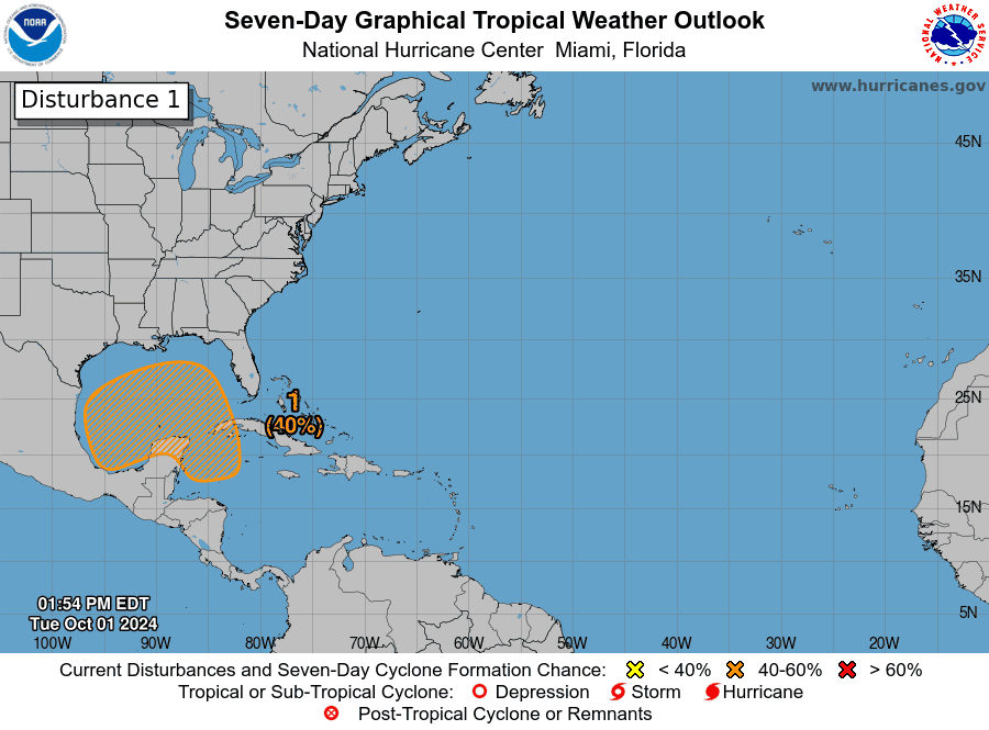
In the tropics, we continue to keep a very close eye on the area of low pressure in the western Caribbean. This feature could become a depression in a few days in the Gulf of Mexico. Computer models are not in agreement as to where it will go and what it will be after that — but it does appear that wind shear could limit the strength of whatever manages to form in the Gulf. We do expect increasing tropical moisture in South Florida by the weekend, but beyond that, nothing is certain until (and if) this feature develops a closed circulation. We’ll keep you posted.
 Elsewhere, Kirk became a hurricane in the central Atlantic Tuesday afternoon, and it is expected to intensify into a major hurricane while remaining in the open ocean. And the area of low pressure in the eastern Atlantic has a high chance of becoming a depression in the next day or so as it moves slowly westward.
Disclaimer
Artificial Intelligence Disclosure & Legal Disclaimer
AI Content Policy.
To provide our readers with timely and comprehensive coverage, South Florida Reporter uses artificial intelligence (AI) to assist in producing certain articles and visual content.
Articles: AI may be used to assist in research, structural drafting, or data analysis. All AI-assisted text is reviewed and edited by our team to ensure accuracy and adherence to our editorial standards.
Images: Any imagery generated or significantly altered by AI is clearly marked with a disclaimer or watermark to distinguish it from traditional photography or editorial illustrations.
General Disclaimer
The information contained in South Florida Reporter is for general information purposes only.
South Florida Reporter assumes no responsibility for errors or omissions in the contents of the Service. In no event shall South Florida Reporter be liable for any special, direct, indirect, consequential, or incidental damages or any damages whatsoever, whether in an action of contract, negligence or other tort, arising out of or in connection with the use of the Service or the contents of the Service.
The Company reserves the right to make additions, deletions, or modifications to the contents of the Service at any time without prior notice. The Company does not warrant that the Service is free of viruses or other harmful components.


")


")

")