

Monday features mostly sunny skies with a few morning showers and maybe an afternoon storm in the East Coast metro area, while the Gulf Coast will see lots of sun with a few afternoon and early evening storms. Expect an elevated risk of dangerous rip currents at the Atlantic beaches at least through Monday. Highs on Monday will be in the low 90s on the mainland and near 90 degrees in the Keys.
Tuesday will bring a mix of sun, clouds, and some afternoon storms in spots. Tuesday’s highs will be in the low 90s on the mainland and near 90 degrees in the Keys.
Wednesday will feature mostly sunny skies with periods of showers and storms in the East Coast metro area. The Gulf Coast will see a mix of sun, clouds, a few morning showers, and periods of storms in the afternoon and early evening. Wednesday’s highs will be near 90 degrees in the East Coast metro area and the Keys and in the low 90s along the Gulf Coast.
Thursday will be mostly sunny with periods of showers and storms on the mainland. Look for clouds and showers in the Keys. Thursday’s highs will be near 90 degrees in the East Coast metro area and the Keys and in the low 90s along the Gulf Coast.

Friday’s forecast calls for some sun, more clouds, and periods of showers and storms. Highs will be mostly in the upper 80s in the East Coast metro area and the Keys and near 90 degrees along the Gulf Coast.
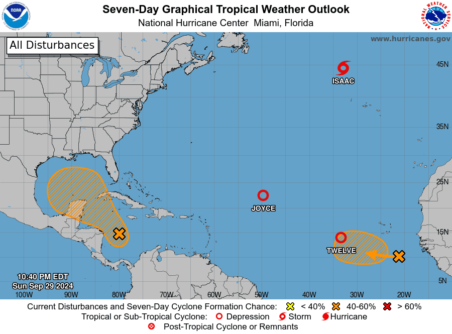 In the busy tropics, Isaac has weakened to a tropical depression in the northern Atlantic and is forecast to become post-tropical in a day or so. Joyce is weakening in the central Atlantic and is expected to become a remnant low on Tuesday — far from land. The low several hundred miles west of the Cape Verde Islands became Tropical Depression # 12 on Sunday as it continued to move westward, with a turn to the northwest anticipated soon. And a wave that recently emerged off the African coast has a medium chance of development.
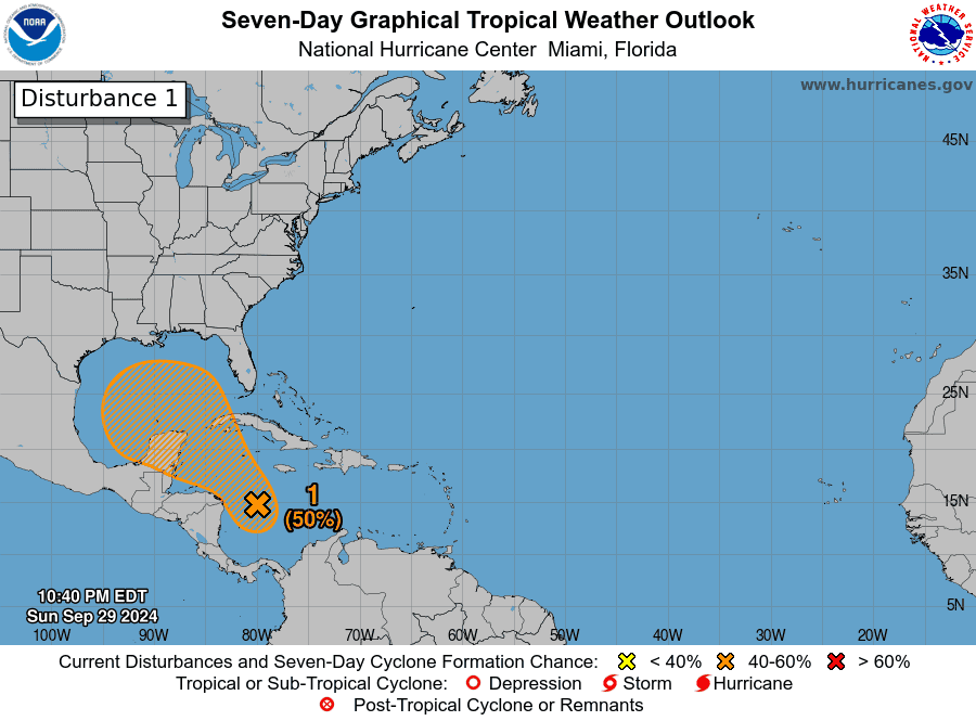 But we continue to watch the western Caribbean, where an area of low pressure is forming. The National Hurricane Center currently gives this feature a medium chance of developing. But it will end up in the Gulf of Mexico in a few days, where conditions remain highly favorable for tropical development. It’s too early to tell where this feature will go — but everyone on the Gulf Coast needs to pay attention to its future track.
Disclaimer
Artificial Intelligence Disclosure & Legal Disclaimer
AI Content Policy.
To provide our readers with timely and comprehensive coverage, South Florida Reporter uses artificial intelligence (AI) to assist in producing certain articles and visual content.
Articles: AI may be used to assist in research, structural drafting, or data analysis. All AI-assisted text is reviewed and edited by our team to ensure accuracy and adherence to our editorial standards.
Images: Any imagery generated or significantly altered by AI is clearly marked with a disclaimer or watermark to distinguish it from traditional photography or editorial illustrations.
General Disclaimer
The information contained in South Florida Reporter is for general information purposes only.
South Florida Reporter assumes no responsibility for errors or omissions in the contents of the Service. In no event shall South Florida Reporter be liable for any special, direct, indirect, consequential, or incidental damages or any damages whatsoever, whether in an action of contract, negligence or other tort, arising out of or in connection with the use of the Service or the contents of the Service.
The Company reserves the right to make additions, deletions, or modifications to the contents of the Service at any time without prior notice. The Company does not warrant that the Service is free of viruses or other harmful components.


")


")

")