

Monday features a mix of sun, clouds, and some afternoon showers and storms in the East Coast metro area. The Gulf Coast will be mostly sunny, but the Keys will see some sun, more clouds, and periods of showers and storms. Minor flooding near high tides is possible along the Atlantic coast. A high risk of dangerous rip currents remains along the Palm Beach County coast. Expect an elevated rip current risk at the beaches of Broward and Miami-Dade. Highs on Monday will be in the mid-80s right at the Atlantic coast and the Keys, while the rest of South Florida will reach the upper 80s.
Tuesday will bring lots of sun and a few afternoon clouds and showers to the East Coast metro area, while the Gulf Coast will see sunny skies. Clouds, showers, and storms will linger in the Keys. Expect an elevated risk of dangerous rip currents along the Palm Beach County coast. Tuesday’s highs will be in the upper 80s on the mainland and the mid-80s in the Keys.
Wednesday will be a sunny day around South Florida. Wednesday’s highs will be in the upper 80s on the mainland and the mid-80s in the Keys.
Thursday will feature lots of sun and a brisk and gusty breeze on the mainland, while the Keys will see sunny skies. Thursday’s highs will be mostly in the mid-80s in the East Coast metro area and the Keys and in the upper 80s in the Keys.

Friday’s forecast calls for lots of sun on the mainland, along with breezy conditions in the East Coast metro area. Look for a mix of sun, clouds, showers, and some storms in the Keys. Highs on Friday will be in the mid-80s in the East Coast metro area and the Keys and in the upper 80s along the Gulf Coast.
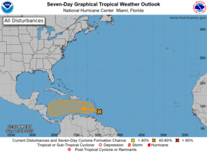 In the tropics, we continue to watch the wave that is now bringing heavy rain and gusty winds to portions of the Lesser Antilles. This wave has a high chance of becoming a depression or tropical storm once it reaches the central Caribbean in a couple of days.
Disclaimer
Artificial Intelligence Disclosure & Legal Disclaimer
AI Content Policy.
To provide our readers with timely and comprehensive coverage, South Florida Reporter uses artificial intelligence (AI) to assist in producing certain articles and visual content.
Articles: AI may be used to assist in research, structural drafting, or data analysis. All AI-assisted text is reviewed and edited by our team to ensure accuracy and adherence to our editorial standards.
Images: Any imagery generated or significantly altered by AI is clearly marked with a disclaimer or watermark to distinguish it from traditional photography or editorial illustrations.
General Disclaimer
The information contained in South Florida Reporter is for general information purposes only.
South Florida Reporter assumes no responsibility for errors or omissions in the contents of the Service. In no event shall South Florida Reporter be liable for any special, direct, indirect, consequential, or incidental damages or any damages whatsoever, whether in an action of contract, negligence or other tort, arising out of or in connection with the use of the Service or the contents of the Service.
The Company reserves the right to make additions, deletions, or modifications to the contents of the Service at any time without prior notice. The Company does not warrant that the Service is free of viruses or other harmful components.


")