

Tuesday features a mix of sun and clouds with periods of storms, mainly in the afternoon and evening. Heavy rain is possible in spots. Highs on Tuesday will be mostly in the low 90s — but it will feel at least 10 degrees hotter. Whether or not a heat advisory is issued, be sure to stay hydrated and out of the sun.
LIVE RADAR 24/7 (Click Here Then Press Play)
Wednesday will bring mostly sunny skies with a few early storms. Then look for lots of storms to develop in the afternoon and linger well into the evening. Wednesday’s highs will be mostly in the low 90s in the east coast metro area and the Keys and in the mid-90s along the Gulf Coast.
Thursday will feature a summertime mix of hot sun, clouds, and storms. Those storms will move in during the mid-afternoon and last into the evening. Thursday’s highs will be mostly in the steamy low 90s.

Friday will be another day of sun, clouds, and storms, especially in the afternoon and evening. Friday’s highs will be mostly in the low 90s.
Saturday’s forecast calls for a mix of sun and a few clouds alternating with periods of showers and storms. Highs on Saturday will be mostly in the mid-90s.
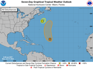 In the tropics, the wave in the central Atlantic remained disorganized on Monday, but the National Hurricane Center still gives it a high chance of becoming a depression or tropical or subtropical storm in the next couple of days- but it will remain in the middle of the ocean. Elsewhere, the area of low pressure that developed off the southeast coast this weekend was accelerating to the northeast and merging with a front on Monday afternoon, so it’s unlikely to develop.
Disclaimer
Artificial Intelligence Disclosure & Legal Disclaimer
AI Content Policy.
To provide our readers with timely and comprehensive coverage, South Florida Reporter uses artificial intelligence (AI) to assist in producing certain articles and visual content.
Articles: AI may be used to assist in research, structural drafting, or data analysis. All AI-assisted text is reviewed and edited by our team to ensure accuracy and adherence to our editorial standards.
Images: Any imagery generated or significantly altered by AI is clearly marked with a disclaimer or watermark to distinguish it from traditional photography or editorial illustrations.
General Disclaimer
The information contained in South Florida Reporter is for general information purposes only.
South Florida Reporter assumes no responsibility for errors or omissions in the contents of the Service. In no event shall South Florida Reporter be liable for any special, direct, indirect, consequential, or incidental damages or any damages whatsoever, whether in an action of contract, negligence or other tort, arising out of or in connection with the use of the Service or the contents of the Service.
The Company reserves the right to make additions, deletions, or modifications to the contents of the Service at any time without prior notice. The Company does not warrant that the Service is free of viruses or other harmful components.


