

Wednesday features hot sun alternating with showers and storms. The Keys will see a mix of sun, clouds, and a few showers. Highs on Wednesday will be mostly in the low 90s, with a few suburban locations in the East Coast metro area reaching the mid-90s. But it will feel about 10 degrees hotter everywhere, so stay hydrated and out of the sun.
Thursday will bring a mix of sun, showers, and storms to the mainland. Look for plenty of clouds and some showers in the Keys. Thursday’s highs will be in the low 90s on the mainland and near 90 degrees in the Keys.
Friday will feature hot sun, showers, and mainly afternoon storms on the mainland, while the Keys will see mostly sunny skies and a few showers. Friday’s highs will be mostly in the low 90s in the east coast metro area and the Keys and in the mid 90s along the Gulf coast.
Saturday will see hot sun and mostly afternoon showers and storms in the east coast metro area, while the Gulf coast will see a sunny morning followed by afternoon showers and storms. The Keys will see more clouds than sun and periods of showers. Saturday’s highs will be mostly in the mid 90s on the mainland and in the low 90s in the Keys.

Sunday’s forecast calls for plenty of hot sun and periods of showers and storms. Highs on Sunday will be mostly in the low 90s.
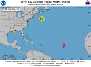 In the tropics, Tropical Storm Erin is forecast to strengthen into a hurricane by the weekend. Late Tuesday afternoon, Erin was about 1635 miles east of the northern Leeward Islands and was moving west at 22 miles per hour. Maximum sustained winds were 45 miles per hour at that time. Erin is forecast to move westward for the next couple of days and then turn to the west-northwest. Computer models indicate that turn to the west-northwest on Thursday or Friday and then a turn to the northwest over the weekend. Timing will be critical to possible impacts to either the Leeward Islands or the Atlantic coast — and we’ll watch all this closely in the coming days.
Elsewhere, the weak low well off the northern New England coast has a low chance of developing before it moves into colder Atlantic waters.
Disclaimer
Artificial Intelligence Disclosure & Legal Disclaimer
AI Content Policy.
To provide our readers with timely and comprehensive coverage, South Florida Reporter uses artificial intelligence (AI) to assist in producing certain articles and visual content.
Articles: AI may be used to assist in research, structural drafting, or data analysis. All AI-assisted text is reviewed and edited by our team to ensure accuracy and adherence to our editorial standards.
Images: Any imagery generated or significantly altered by AI is clearly marked with a disclaimer or watermark to distinguish it from traditional photography or editorial illustrations.
General Disclaimer
The information contained in South Florida Reporter is for general information purposes only.
South Florida Reporter assumes no responsibility for errors or omissions in the contents of the Service. In no event shall South Florida Reporter be liable for any special, direct, indirect, consequential, or incidental damages or any damages whatsoever, whether in an action of contract, negligence or other tort, arising out of or in connection with the use of the Service or the contents of the Service.
The Company reserves the right to make additions, deletions, or modifications to the contents of the Service at any time without prior notice. The Company does not warrant that the Service is free of viruses or other harmful components.


")


