

Thursday features hot sun and mainly afternoon showers and storms in the East Coast metro area, while the Gulf Coast will see sun and showers in the morning and storms in the afternoon. Look for clouds and showers in the Keys. Highs on Thursday will be mostly in the low 90s, with some suburban locations topping out in the mid-90s. But it will feel at least 10 degrees hotter, so stay hydrated and out of the sun.
Friday will bring a mix of sun and storms in the morning, followed by plenty of showers in the afternoon and early evening. Friday’s highs will be in the low 90s.
Saturday will feature hot sun and periods of storms, especially in the afternoon and early evening in the East Coast metro area and the Keys. The Gulf Coast will see sun and a few showers in the morning and storms in the afternoon that will last into the evening. Saturday’s highs will be in the low 90s.

Sunday will be mostly sunny with periods of showers and storms. Sunday’s highs will be in the low 90s on the mainland and near 90 degrees in the Keys.
Monday’s forecast calls for hot sun with some showers and storms in spots. Highs on Monday will be mostly in the mid-90s in the East Coast metro area and in the low 90s along the Gulf Coast and in the Keys.
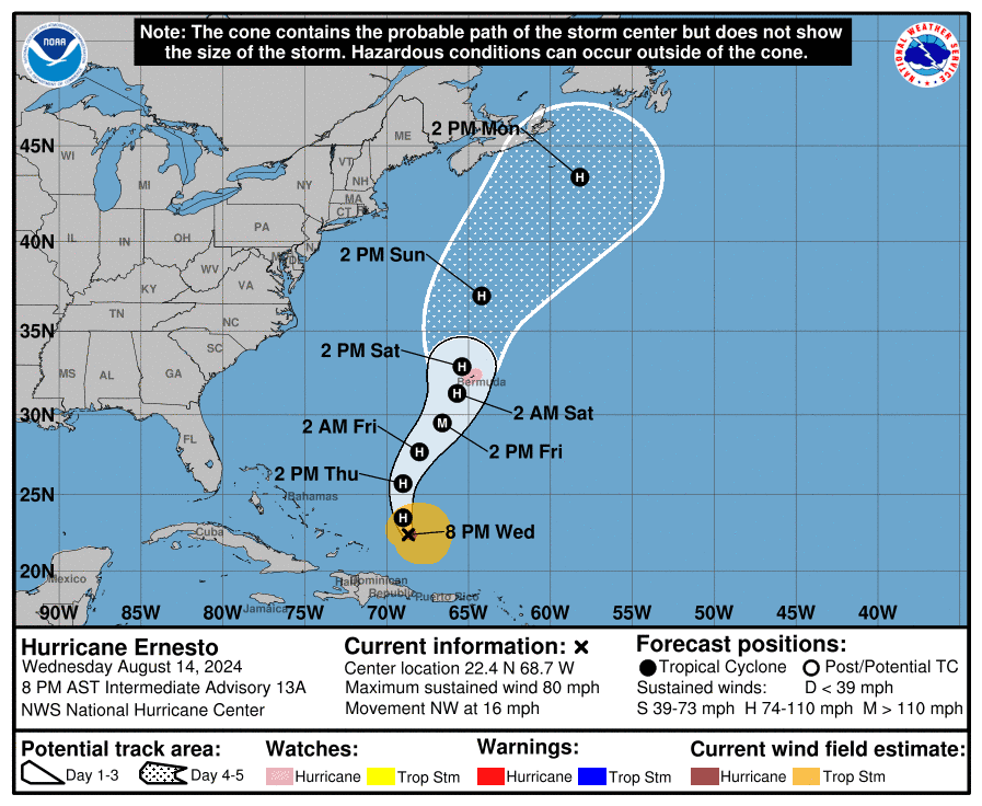 In the tropics, Ernesto reached hurricane strength as it moved north of Puerto Rico late Wednesday morning. At 8 pm Wednesday, Hurricane Ernesto had maximum sustained winds of 80 miles per hour, and it was moving northwest at 16 miles per hour. Ernesto is forecast to become a major hurricane by Friday and pass very near or over Bermuda on Saturday. A hurricane watch is now in effect for Bermuda.
Disclaimer
Artificial Intelligence Disclosure & Legal Disclaimer
AI Content Policy.
To provide our readers with timely and comprehensive coverage, South Florida Reporter uses artificial intelligence (AI) to assist in producing certain articles and visual content.
Articles: AI may be used to assist in research, structural drafting, or data analysis. All AI-assisted text is reviewed and edited by our team to ensure accuracy and adherence to our editorial standards.
Images: Any imagery generated or significantly altered by AI is clearly marked with a disclaimer or watermark to distinguish it from traditional photography or editorial illustrations.
General Disclaimer
The information contained in South Florida Reporter is for general information purposes only.
South Florida Reporter assumes no responsibility for errors or omissions in the contents of the Service. In no event shall South Florida Reporter be liable for any special, direct, indirect, consequential, or incidental damages or any damages whatsoever, whether in an action of contract, negligence or other tort, arising out of or in connection with the use of the Service or the contents of the Service.
The Company reserves the right to make additions, deletions, or modifications to the contents of the Service at any time without prior notice. The Company does not warrant that the Service is free of viruses or other harmful components.


")


")
