

 Stormy days are ahead for South Florida starting on Friday as a tropical disturbance slides northward off our coast. Look for plenty of clouds and periods of showers and storms on Friday, with heavy downpours in spots. Localized flooding is possible, especially in areas where debris from Irma has clogged storm drains. A moderate risk of rip currents remains in place for the beaches of Palm Beach County, but the risk is somewhat lower at other Atlantic beaches. Highs on Friday will be in the mid to upper 80s.
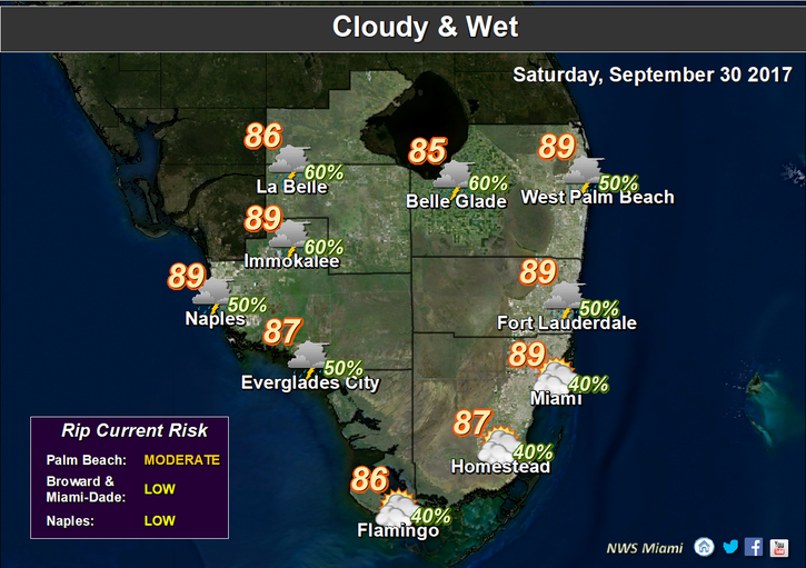 Showers and storms will pass by overnight, and Saturday features some sun, more clouds, showers, and storms. Localized flooding is possible again in some spots. Saturday’s highs will be in the upper 80s.
Look for a bit of sun and mostly clouds and passing showers and storms on Sunday. Highs on Sunday will be in the upper 80s.
Monday will be breezy, and we’ll see passing showers and storms along with some sun. Monday’s highs will be in the upper 80s.

Tuesday will be another breezy day with periods of showers and storms. Highs on Tuesday will be in the upper 80s.
 In the tropics, the area of disturbed weather to our south has a medium chance of becoming into a depression over the weekend, before upper level winds inhibit development. But the real concern with this system is rainfall — and we’re likely to see about 3 inches overall, with more rainfall possible in some locations. Elsewhere, Tropical Storm Maria is finally racing out to sea, as is Hurricane Lee. At 5 am Friday, Maria was located near 37.2 North, 63.3 West, and was moving east at 21 miles per hour. Maximum sustained winds were 60 miles per hour. Lee was located near 38.3 North, 52.4 West, and was zipping northeast at 25 miles per hour. Lee’s maximum sustained winds were down to 75 miles per hour — and we’re glad to see both of them go away.
Disclaimer
Artificial Intelligence Disclosure & Legal Disclaimer
AI Content Policy.
To provide our readers with timely and comprehensive coverage, South Florida Reporter uses artificial intelligence (AI) to assist in producing certain articles and visual content.
Articles: AI may be used to assist in research, structural drafting, or data analysis. All AI-assisted text is reviewed and edited by our team to ensure accuracy and adherence to our editorial standards.
Images: Any imagery generated or significantly altered by AI is clearly marked with a disclaimer or watermark to distinguish it from traditional photography or editorial illustrations.
General Disclaimer
The information contained in South Florida Reporter is for general information purposes only.
South Florida Reporter assumes no responsibility for errors or omissions in the contents of the Service. In no event shall South Florida Reporter be liable for any special, direct, indirect, consequential, or incidental damages or any damages whatsoever, whether in an action of contract, negligence or other tort, arising out of or in connection with the use of the Service or the contents of the Service.
The Company reserves the right to make additions, deletions, or modifications to the contents of the Service at any time without prior notice. The Company does not warrant that the Service is free of viruses or other harmful components.


")